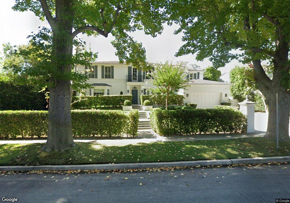
301 Loring Ave Los Angeles, CA 90024
Westwood NeighborhoodEstimated Value: $6,501,000 - $9,498,496
6
Beds
5
Baths
4,308
Sq Ft
$1,914/Sq Ft
Est. Value
About This Home
This home is located at 301 Loring Ave, Los Angeles, CA 90024 and is currently estimated at $8,247,374, approximately $1,914 per square foot. 301 Loring Ave is a home located in Los Angeles County with nearby schools including Warner Avenue Elementary, Ralph Waldo Emerson Community Charter Middle School, and University High School Charter.
Ownership History
Date
Name
Owned For
Owner Type
Purchase Details
Closed on
Jan 10, 2018
Sold by
Saffari Moini Nazie and Moini Family Trust
Bought by
Saffari Moini Nazie and Nazie Saffari Survivor S Trust
Current Estimated Value
Purchase Details
Closed on
Aug 30, 2010
Sold by
Bell Lionel and Bell Theresa Ruth
Bought by
Moini Syed Sabur and Saffari Moini Nazie
Home Financials for this Owner
Home Financials are based on the most recent Mortgage that was taken out on this home.
Original Mortgage
$1,500,000
Interest Rate
3.74%
Mortgage Type
New Conventional
Create a Home Valuation Report for This Property
The Home Valuation Report is an in-depth analysis detailing your home's value as well as a comparison with similar homes in the area
Home Values in the Area
Average Home Value in this Area
Purchase History
| Date | Buyer | Sale Price | Title Company |
|---|---|---|---|
| Saffari Moini Nazie | -- | None Available | |
| Moini Syed Sabur | $2,770,027 | Fidelity Van Nuys |
Source: Public Records
Mortgage History
| Date | Status | Borrower | Loan Amount |
|---|---|---|---|
| Previous Owner | Moini Syed Sabur | $1,500,000 |
Source: Public Records
Tax History Compared to Growth
Tax History
| Year | Tax Paid | Tax Assessment Tax Assessment Total Assessment is a certain percentage of the fair market value that is determined by local assessors to be the total taxable value of land and additions on the property. | Land | Improvement |
|---|---|---|---|---|
| 2025 | $68,707 | $5,765,427 | $3,548,859 | $2,216,568 |
| 2024 | $68,707 | $5,652,380 | $3,479,274 | $2,173,106 |
| 2023 | $67,365 | $5,541,550 | $3,411,053 | $2,130,497 |
| 2022 | $64,215 | $5,432,893 | $3,344,170 | $2,088,723 |
| 2021 | $63,437 | $5,326,367 | $3,278,599 | $2,047,768 |
| 2019 | $61,525 | $5,168,385 | $3,181,354 | $1,987,031 |
| 2018 | $61,297 | $5,067,045 | $3,118,975 | $1,948,070 |
| 2016 | $65,756 | $5,475,703 | $2,997,862 | $2,477,841 |
| 2015 | $64,494 | $2,952,832 | $2,952,832 | $0 |
| 2014 | $35,502 | $2,894,991 | $2,894,991 | $0 |
Source: Public Records
Map
Nearby Homes
- 365 Comstock Ave
- 10444 Charing Cross Rd
- 365 Norcroft Ave
- 453 Dalehurst Ave
- 547 Loring Ave
- 601 Woodruff Ave
- 570 S Beverly Glen Blvd
- 200 S Mapleton Dr
- 101 Bel Air Rd
- 570 S Mapleton Dr
- 133 S Mapleton Dr
- 107 Delfern Dr
- 235 St Pierre Rd
- 10386 Strathmore Dr
- 259 St Pierre Rd
- 112 N Beverly Glen Blvd
- 10301 Strathmore Dr
- 740 Warner Ave
- 10644 Bellagio Rd
- 327 Delfern Dr
- 291 Loring Ave
- 317 Loring Ave
- 281 Loring Ave
- 374 Comstock Ave
- 350 Comstock Ave
- 308 Loring Ave
- 333 Loring Ave
- 314 Loring Ave
- 10440 Charing Cross Rd
- 322 Loring Ave
- 342 Comstock Ave
- 271 Loring Ave
- 276 Loring Ave
- 328 Loring Ave
- 334 Comstock Ave
- 336 Loring Ave
- 272 Woodruff Ave
- 401 Lomond Ave
- 263 Loring Ave
- 357 Comstock Ave