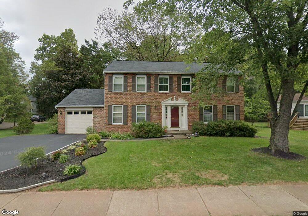
3119 Nestlewood Dr Herndon, VA 20171
Oak Hill NeighborhoodEstimated Value: $900,895 - $1,051,000
5
Beds
4
Baths
2,352
Sq Ft
$409/Sq Ft
Est. Value
About This Home
This home is located at 3119 Nestlewood Dr, Herndon, VA 20171 and is currently estimated at $960,974, approximately $408 per square foot. 3119 Nestlewood Dr is a home located in Fairfax County with nearby schools including Navy Elementary, Franklin Middle, and Reston Day School.
Ownership History
Date
Name
Owned For
Owner Type
Purchase Details
Closed on
Aug 4, 1998
Sold by
Anderson David K
Bought by
Lin James C
Current Estimated Value
Home Financials for this Owner
Home Financials are based on the most recent Mortgage that was taken out on this home.
Original Mortgage
$118,000
Outstanding Balance
$24,617
Interest Rate
6.92%
Estimated Equity
$936,357
Purchase Details
Closed on
Jan 7, 1998
Sold by
Anderson David and Anderson Emily B
Bought by
David & Emily B Anderson Trust
Purchase Details
Closed on
Dec 6, 1993
Sold by
Perry
Bought by
Anderson David
Home Financials for this Owner
Home Financials are based on the most recent Mortgage that was taken out on this home.
Original Mortgage
$150,000
Interest Rate
6.69%
Create a Home Valuation Report for This Property
The Home Valuation Report is an in-depth analysis detailing your home's value as well as a comparison with similar homes in the area
Home Values in the Area
Average Home Value in this Area
Purchase History
| Date | Buyer | Sale Price | Title Company |
|---|---|---|---|
| Lin James C | $233,000 | -- | |
| David & Emily B Anderson Trust | -- | -- | |
| Anderson David | $220,000 | -- |
Source: Public Records
Mortgage History
| Date | Status | Borrower | Loan Amount |
|---|---|---|---|
| Open | Anderson David | $118,000 | |
| Previous Owner | Anderson David | $150,000 |
Source: Public Records
Tax History Compared to Growth
Tax History
| Year | Tax Paid | Tax Assessment Tax Assessment Total Assessment is a certain percentage of the fair market value that is determined by local assessors to be the total taxable value of land and additions on the property. | Land | Improvement |
|---|---|---|---|---|
| 2025 | $8,793 | $841,560 | $340,000 | $501,560 |
| 2024 | $8,793 | $758,970 | $300,000 | $458,970 |
| 2023 | $8,725 | $773,170 | $300,000 | $473,170 |
| 2022 | $8,333 | $728,720 | $280,000 | $448,720 |
| 2021 | $7,034 | $599,430 | $230,000 | $369,430 |
| 2020 | $6,942 | $586,530 | $230,000 | $356,530 |
| 2019 | $6,942 | $586,530 | $230,000 | $356,530 |
| 2018 | $6,650 | $578,250 | $227,000 | $351,250 |
| 2017 | $6,513 | $561,020 | $220,000 | $341,020 |
| 2016 | $6,499 | $561,020 | $220,000 | $341,020 |
| 2015 | $6,261 | $561,020 | $220,000 | $341,020 |
| 2014 | $6,001 | $538,950 | $210,000 | $328,950 |
Source: Public Records
Map
Nearby Homes
- 12816 Cross Creek Ln
- 13019 Bankfoot Ct
- 3350 Stone Heather Ct
- 3025 Hughsmith Ct
- 3252 Tayloe Ct
- 13110 Thompson Rd
- 13430 Hidden Meadow Ct
- 12704 Autumn Crest Dr
- 2913 Mother Well Ct
- 3245 Kinross Cir
- 13505 Coates Ln
- 13371 Teaberry Ct
- 2704 Viking Dr
- 13512 Apple Barrel Ct
- 3494 Audubon Cove
- 3559 Plum Dale Dr
- 2700 Reign St
- 3142 Searsmont Place
- 3140 Searsmont Place
- 3144 Searsmont Place
- 3117 Nestlewood Dr
- 13120 Bramblewood Ln
- 3113 Nestlewood Dr
- 3115 Nestlewood Dr
- 3122 Nestlewood Dr
- 3120 Nestlewood Dr
- 13118 Bramblewood Ln
- 3118 Nestlewood Dr
- 3111 Nestlewood Dr
- 3124 Nestlewood Dr
- 12989 Thistlethorn Dr
- 12987 Thistlethorn Dr
- 3123 Nestlewood Dr
- 13116 Bramblewood Ln
- 12991 Thistlethorn Dr
- 3116 Nestlewood Dr
- 3109 Nestlewood Dr
- 13119 Bramblewood Ln
- 13122 Thornapple Place
- 12983 Thistlethorn Dr