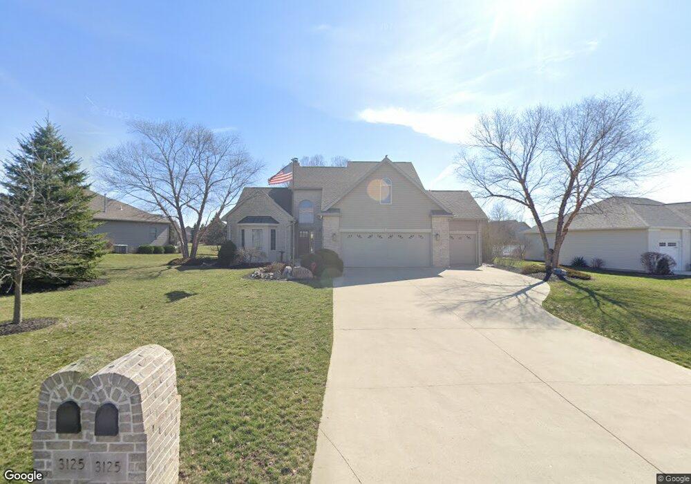
3125 Jurnee Dr Findlay, OH 45840
Estimated Value: $429,000 - $483,000
3
Beds
3
Baths
2,138
Sq Ft
$214/Sq Ft
Est. Value
About This Home
This home is located at 3125 Jurnee Dr, Findlay, OH 45840 and is currently estimated at $457,197, approximately $213 per square foot. 3125 Jurnee Dr is a home located in Hancock County with nearby schools including Liberty-Benton Elementary School, Liberty-Benton Middle School, and Liberty-Benton High School.
Ownership History
Date
Name
Owned For
Owner Type
Purchase Details
Closed on
Oct 2, 2001
Sold by
Petti Constr Co Inc
Bought by
Becker Raphael T and Becker Sue Ann
Current Estimated Value
Home Financials for this Owner
Home Financials are based on the most recent Mortgage that was taken out on this home.
Original Mortgage
$207,200
Outstanding Balance
$81,579
Interest Rate
6.97%
Mortgage Type
New Conventional
Estimated Equity
$375,618
Create a Home Valuation Report for This Property
The Home Valuation Report is an in-depth analysis detailing your home's value as well as a comparison with similar homes in the area
Home Values in the Area
Average Home Value in this Area
Purchase History
| Date | Buyer | Sale Price | Title Company |
|---|---|---|---|
| Becker Raphael T | $259,000 | -- |
Source: Public Records
Mortgage History
| Date | Status | Borrower | Loan Amount |
|---|---|---|---|
| Open | Becker Raphael T | $207,200 |
Source: Public Records
Tax History Compared to Growth
Tax History
| Year | Tax Paid | Tax Assessment Tax Assessment Total Assessment is a certain percentage of the fair market value that is determined by local assessors to be the total taxable value of land and additions on the property. | Land | Improvement |
|---|---|---|---|---|
| 2024 | $5,035 | $135,440 | $18,750 | $116,690 |
| 2023 | $4,916 | $135,440 | $18,750 | $116,690 |
| 2022 | $4,868 | $135,440 | $18,750 | $116,690 |
| 2021 | $4,775 | $117,280 | $17,500 | $99,780 |
| 2020 | $4,816 | $117,280 | $17,500 | $99,780 |
| 2019 | $4,620 | $117,280 | $17,500 | $99,780 |
| 2018 | $3,639 | $101,980 | $15,210 | $86,770 |
| 2017 | $1,877 | $101,980 | $15,210 | $86,770 |
| 2016 | $3,638 | $101,980 | $15,210 | $86,770 |
| 2015 | $3,476 | $94,930 | $13,980 | $80,950 |
| 2014 | $3,508 | $94,930 | $13,980 | $80,950 |
| 2012 | $3,663 | $94,930 | $13,980 | $80,950 |
Source: Public Records
Map
Nearby Homes
- 0 County Road 95 Unit 6097574
- 6535 Silver Lake Dr
- 1405 Cypress Lake
- 3106 Saddlebrook
- 0 Rock Candy Rd Unit Lot 159
- 0 Rock Candy Rd Unit Lot 170
- 0 Rock Candy Rd Unit Lot 172 206819
- 0 Rock Candy Rd Unit Lot 162
- 0 Rock Candy Rd Unit Lot 171
- 0 Rock Candy Rd Unit Lot 168
- 0 Rock Candy Rd Or Bushwillow Dr Unit Lot 173
- 0 Bushwillow Dr Or Rock Candy Rd Unit Lot 157
- 3018 Gleneagle Dr
- 0 Bearcat Way Or Rock Candy Rd Unit Lot 167
- 0 County Road 140
- 1310 Muirfield Dr
- 933 Laurel Ln
- 0 Allen Township 142
- 925 W Melrose Ave
- 9960 W Us Route 224
- 3209 Jurnee Dr
- 3107 Jurnee Dr
- 0 Jurnee Dr Unit 138561
- 0 Jurnee Dr Unit 106724
- 0 Jurnee Dr Unit 102983
- 0 Jurnee Dr Unit H132848
- 0 Jurnee Dr
- 3221 Jurnee Dr
- 3112 Bay Tree Dr
- 1936 Lakeland Dr
- 3116 Jurnee Dr
- 1924 Lakeland Dr
- 3106 Bay Tree Dr
- 3200 Jurnee Dr
- 3108 Jurnee Dr
- 3212 Jurnee Dr
- 3118 Bay Tree Dr
- 1912 Lakeland Dr
- 2000 Lakeland Dr
- 3224 Jurnee Dr