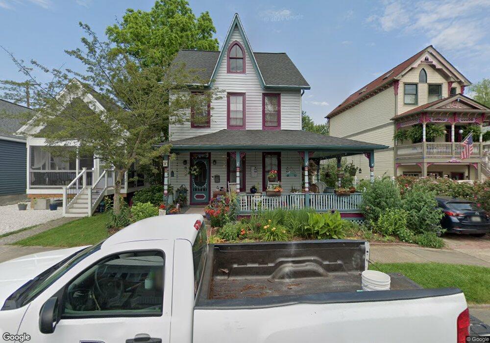
315 Alliance St Havre de Grace, MD 21078
Estimated Value: $416,664 - $512,000
4
Beds
2
Baths
3,066
Sq Ft
$152/Sq Ft
Est. Value
About This Home
This home is located at 315 Alliance St, Havre de Grace, MD 21078 and is currently estimated at $464,666, approximately $151 per square foot. 315 Alliance St is a home located in Harford County with nearby schools including Havre de Grace Elementary School, Havre de Grace Middle School, and Havre de Grace High School.
Ownership History
Date
Name
Owned For
Owner Type
Purchase Details
Closed on
Aug 25, 2009
Sold by
Phillips-Custer Tara M
Bought by
Nemeth Elizabeth C and Hutchison Eric J
Current Estimated Value
Purchase Details
Closed on
Feb 4, 2003
Sold by
Phillips Tara M
Bought by
Phillips Custer Tara M and Custer James C
Purchase Details
Closed on
Jun 6, 2000
Sold by
Avalon Vacation Weeks Inc
Bought by
Phillips Tara M
Purchase Details
Closed on
Oct 22, 1999
Sold by
Owens William E
Bought by
Contimortgage Corporation
Create a Home Valuation Report for This Property
The Home Valuation Report is an in-depth analysis detailing your home's value as well as a comparison with similar homes in the area
Home Values in the Area
Average Home Value in this Area
Purchase History
| Date | Buyer | Sale Price | Title Company |
|---|---|---|---|
| Nemeth Elizabeth C | $261,000 | -- | |
| Phillips Custer Tara M | -- | -- | |
| Phillips Tara M | $90,000 | -- | |
| Avalon Vacation Weeks Inc | $71,250 | -- | |
| Contimortgage Corporation | $95,000 | -- |
Source: Public Records
Mortgage History
| Date | Status | Borrower | Loan Amount |
|---|---|---|---|
| Closed | Nemeth Elizabeth C | -- |
Source: Public Records
Tax History Compared to Growth
Tax History
| Year | Tax Paid | Tax Assessment Tax Assessment Total Assessment is a certain percentage of the fair market value that is determined by local assessors to be the total taxable value of land and additions on the property. | Land | Improvement |
|---|---|---|---|---|
| 2025 | $2,694 | $296,500 | $0 | $0 |
| 2024 | $2,694 | $282,600 | $64,000 | $218,600 |
| 2023 | $2,582 | $270,833 | $0 | $0 |
| 2022 | $2,470 | $259,067 | $0 | $0 |
| 2021 | $1,211 | $247,300 | $64,000 | $183,300 |
| 2020 | $1,211 | $240,733 | $0 | $0 |
| 2019 | $2,355 | $234,167 | $0 | $0 |
| 2018 | $2,269 | $227,600 | $74,000 | $153,600 |
| 2017 | $2,269 | $227,600 | $0 | $0 |
| 2016 | -- | $227,600 | $0 | $0 |
| 2015 | $2,567 | $231,900 | $0 | $0 |
| 2014 | $2,567 | $231,900 | $0 | $0 |
Source: Public Records
Map
Nearby Homes
- 605 Concord St Unit 3E
- 12 Concord Place
- 313 S Washington St
- 243 Blue Bill Ln
- 247 D Fountain St
- 562 Girard St
- 610 Lewis St
- 317 S Stokes St
- 110 S Washington St
- 714 Revolution St
- 556 Congress Ave
- 726 Girard St
- 202 Seneca Way Unit 38
- Sophia Plan at Bulle Rock - Villas
- Jordan II Plan at Bulle Rock - Villas
- Jordan III Plan at Bulle Rock - Villas
- Carson II Plan at Bulle Rock - Villas
- 952 Chesapeake Dr
- 977 Chesapeake Dr
- 105 Concove Way
- 309 Alliance St
- 317 Alliance St
- 307 Alliance St
- 319 Alliance St
- 303 Alliance St
- 614 Market St
- 612 Market St
- 353 Alliance St
- 316 Alliance St
- 318 Alliance St
- 606 Market St
- 320 Lewis St
- 310 Alliance St
- 700 Market St
- 706 Market St
- 600 Market St
- 332 Lewis St
- 358 Alliance St
- 617 Market St
- 617 S Washington St