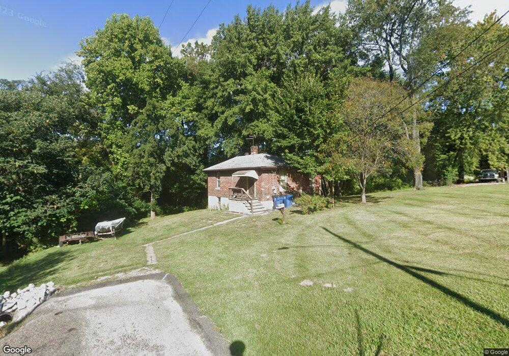
315 Garnet St Collinsville, IL 62234
Estimated Value: $111,000 - $136,000
3
Beds
1
Bath
776
Sq Ft
$161/Sq Ft
Est. Value
About This Home
This home is located at 315 Garnet St, Collinsville, IL 62234 and is currently estimated at $125,274, approximately $161 per square foot. 315 Garnet St is a home located in Madison County with nearby schools including John A Renfro Elementary School, Dorris Intermediate School, and Collinsville Middle School.
Ownership History
Date
Name
Owned For
Owner Type
Purchase Details
Closed on
Apr 26, 2016
Sold by
Jalinsky Vincent V and Jalinsky Michelle C
Bought by
Jalinsky and Jalinsky Michelle C
Current Estimated Value
Home Financials for this Owner
Home Financials are based on the most recent Mortgage that was taken out on this home.
Original Mortgage
$25,000
Outstanding Balance
$10,779
Interest Rate
2.99%
Mortgage Type
New Conventional
Estimated Equity
$114,495
Purchase Details
Closed on
Jan 12, 2012
Sold by
Clark Barbara
Bought by
Jalinsky Vincent
Create a Home Valuation Report for This Property
The Home Valuation Report is an in-depth analysis detailing your home's value as well as a comparison with similar homes in the area
Home Values in the Area
Average Home Value in this Area
Purchase History
| Date | Buyer | Sale Price | Title Company |
|---|---|---|---|
| Jalinsky | -- | Abstracts & Titles Inc | |
| Jalinsky Vincent | -- | None Available |
Source: Public Records
Mortgage History
| Date | Status | Borrower | Loan Amount |
|---|---|---|---|
| Open | Jalinsky | $25,000 |
Source: Public Records
Tax History Compared to Growth
Tax History
| Year | Tax Paid | Tax Assessment Tax Assessment Total Assessment is a certain percentage of the fair market value that is determined by local assessors to be the total taxable value of land and additions on the property. | Land | Improvement |
|---|---|---|---|---|
| 2024 | $2,186 | $34,190 | $7,200 | $26,990 |
| 2023 | $2,186 | $31,640 | $6,660 | $24,980 |
| 2022 | $2,082 | $28,470 | $5,960 | $22,510 |
| 2021 | $1,848 | $26,750 | $5,600 | $21,150 |
| 2020 | $1,781 | $25,520 | $5,340 | $20,180 |
| 2019 | $1,734 | $24,650 | $5,160 | $19,490 |
| 2018 | $1,452 | $19,930 | $5,190 | $14,740 |
| 2017 | $1,450 | $19,540 | $5,090 | $14,450 |
| 2016 | $1,527 | $19,540 | $5,090 | $14,450 |
| 2015 | $975 | $19,030 | $4,960 | $14,070 |
| 2014 | $975 | $19,030 | $4,960 | $14,070 |
| 2013 | $975 | $19,030 | $4,960 | $14,070 |
Source: Public Records
Map
Nearby Homes
- 0 Strong Ave
- 123 Elliot St
- 123 W Wickliffe Ave
- 580 N Guernsey St
- 510 N Combs Ave
- 617 N Morrison Ave
- 0 Elm St
- 300 N Combs Ave
- 5 Brookwood Dr
- 419 Bell St
- 308 Brown Ave
- 1224 Cedar Ridge Ct
- 22 Brookwood Dr
- 221 N Hesperia St Unit 221 A and 221 B
- 506 W Clay St
- 1121 Carraway Ct
- 119 N Hesperia St
- 1120 Williams St
- 611 W Main St
- 501 Spring
- 313 Garnet St
- 309 Garnet St
- 307 Garnet St
- 315 W Washington St
- 309 W Washington St
- 401 W Washington St
- 303 W Washington St
- 701 Strong Ave
- 314 W Washington St
- 705 Strong Ave
- 310 W Washington St
- 313 W Washington St
- 306 W Washington St
- 304 W Washington St
- 711 Strong Ave
- 211 W Washington St
- 124 Elliot St
- 215 W Lincoln St
- 210 W Lincoln St
- 302 W Washington St