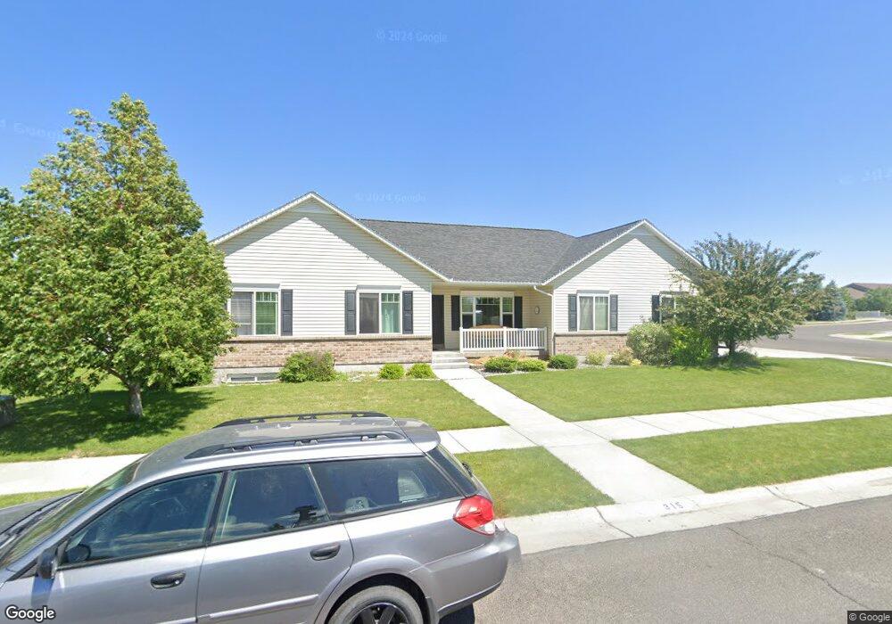
315 Polo Dr Rexburg, ID 83440
Estimated Value: $421,000 - $483,936
3
Beds
2
Baths
3,014
Sq Ft
$153/Sq Ft
Est. Value
About This Home
This home is located at 315 Polo Dr, Rexburg, ID 83440 and is currently estimated at $460,484, approximately $152 per square foot. 315 Polo Dr is a home located in Madison County with nearby schools including Burton Elementary School, Kennedy Elementary School, and Madison Junior High School.
Ownership History
Date
Name
Owned For
Owner Type
Purchase Details
Closed on
Jan 27, 2025
Sold by
Hale Elizabeth A and Hale Andrew T
Bought by
Hale Elizabeth A
Current Estimated Value
Purchase Details
Closed on
Aug 19, 2024
Sold by
Hale Andrew T
Bought by
Hale Elizabeth A
Purchase Details
Closed on
Aug 20, 2020
Sold by
Brusman Eric and Brusman Natalie
Bought by
Hale Andrew T and Hale Elizabeth A
Home Financials for this Owner
Home Financials are based on the most recent Mortgage that was taken out on this home.
Original Mortgage
$349,200
Interest Rate
3%
Mortgage Type
New Conventional
Purchase Details
Closed on
May 28, 2009
Sold by
Whisperwood Homes Corp
Bought by
Brusman Eric and Brusman Natalie
Create a Home Valuation Report for This Property
The Home Valuation Report is an in-depth analysis detailing your home's value as well as a comparison with similar homes in the area
Home Values in the Area
Average Home Value in this Area
Purchase History
| Date | Buyer | Sale Price | Title Company |
|---|---|---|---|
| Hale Elizabeth A | -- | None Listed On Document | |
| Hale Elizabeth A | -- | None Listed On Document | |
| Hale Andrew T | -- | Alliance Ttl Rexburg Office | |
| Brusman Eric | -- | -- |
Source: Public Records
Mortgage History
| Date | Status | Borrower | Loan Amount |
|---|---|---|---|
| Previous Owner | Hale Andrew T | $349,200 |
Source: Public Records
Tax History Compared to Growth
Tax History
| Year | Tax Paid | Tax Assessment Tax Assessment Total Assessment is a certain percentage of the fair market value that is determined by local assessors to be the total taxable value of land and additions on the property. | Land | Improvement |
|---|---|---|---|---|
| 2025 | $2,608 | $416,965 | $65,000 | $351,965 |
| 2024 | $2,608 | $411,965 | $60,000 | $351,965 |
| 2023 | $2,608 | $402,837 | $60,000 | $342,837 |
| 2022 | $3,262 | $385,271 | $50,000 | $335,271 |
| 2021 | $3,018 | $328,841 | $40,000 | $288,841 |
| 2020 | $2,311 | $264,635 | $40,000 | $224,635 |
| 2019 | $2,301 | $236,804 | $40,000 | $196,804 |
| 2018 | $1,975 | $216,925 | $40,000 | $176,925 |
| 2017 | $1,859 | $206,985 | $40,000 | $166,985 |
| 2016 | $1,895 | $206,985 | $40,000 | $166,985 |
| 2015 | $1,657 | $187,106 | $0 | $0 |
| 2013 | -- | $181,455 | $0 | $0 |
Source: Public Records
Map
Nearby Homes
- 758 Yost St
- TBD Titan Dr Unit LOT 9
- 354 Oaktrail Dr
- 616 Trejo St
- 571 Park St
- 576 Park St
- 880 Liberty Ln
- 871 Widdison Ln
- 562 Taurus Dr
- 565 Pioneer Rd Unit 194
- 565 Pioneer Rd Unit 221
- 885 W Main St Unit Lot 2
- 509 S 5th W
- 410 Sunflower Rd
- 530 Sunflower Rd
- 517 W Main St
- 507 W Main St
- 575 Countryside Ave
- 115 S 4th W
- 52 W Sunset Cir