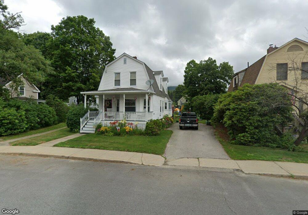
32 Church St Lincoln, NH 03251
Estimated Value: $458,000 - $583,000
3
Beds
2
Baths
1,341
Sq Ft
$371/Sq Ft
Est. Value
About This Home
This home is located at 32 Church St, Lincoln, NH 03251 and is currently estimated at $497,295, approximately $370 per square foot. 32 Church St is a home with nearby schools including Lin-Wood Public Elementary School.
Ownership History
Date
Name
Owned For
Owner Type
Purchase Details
Closed on
Sep 19, 2013
Sold by
Johnson Catherine
Bought by
Adwen Kai Goode Irt and Goode Ft
Current Estimated Value
Purchase Details
Closed on
Sep 17, 2013
Sold by
Goode Maryellen
Bought by
Adwen Kai Goode Irt and Grizzard Susan L
Purchase Details
Closed on
Nov 16, 2004
Sold by
Tetley David W and Tetley Lori N
Bought by
Johnson Peter and Johnson Catherine
Home Financials for this Owner
Home Financials are based on the most recent Mortgage that was taken out on this home.
Original Mortgage
$136,000
Interest Rate
5.75%
Mortgage Type
Purchase Money Mortgage
Create a Home Valuation Report for This Property
The Home Valuation Report is an in-depth analysis detailing your home's value as well as a comparison with similar homes in the area
Home Values in the Area
Average Home Value in this Area
Purchase History
| Date | Buyer | Sale Price | Title Company |
|---|---|---|---|
| Adwen Kai Goode Irt | $195,000 | -- | |
| Adwen Kai Goode Irt | $195,000 | -- | |
| Adwen Kai Goode Irt | -- | -- | |
| Adwen Kai Goode Irt | -- | -- | |
| Johnson Peter | $170,000 | -- | |
| Johnson Peter | $170,000 | -- |
Source: Public Records
Mortgage History
| Date | Status | Borrower | Loan Amount |
|---|---|---|---|
| Previous Owner | Johnson Peter | $36,500 | |
| Previous Owner | Johnson Peter | $136,000 |
Source: Public Records
Tax History Compared to Growth
Tax History
| Year | Tax Paid | Tax Assessment Tax Assessment Total Assessment is a certain percentage of the fair market value that is determined by local assessors to be the total taxable value of land and additions on the property. | Land | Improvement |
|---|---|---|---|---|
| 2024 | $3,310 | $283,400 | $139,800 | $143,600 |
| 2023 | $3,310 | $283,400 | $139,800 | $143,600 |
| 2022 | $2,988 | $283,200 | $139,800 | $143,400 |
| 2021 | $2,985 | $283,200 | $139,800 | $143,400 |
| 2018 | $2,494 | $176,100 | $52,800 | $123,300 |
| 2016 | $2,323 | $176,100 | $52,800 | $123,300 |
| 2015 | $2,351 | $170,600 | $66,500 | $104,100 |
| 2014 | $2,354 | $170,600 | $66,500 | $104,100 |
| 2009 | $1,840 | $201,950 | $96,400 | $105,550 |
Source: Public Records
Map
Nearby Homes
- 13 Maple St
- 11 Church St
- 164 Pollard Rd
- 158 Pollard Rd
- 0 Pleasant St Unit 87
- 12 Twin Tip Terrace Unit 10
- 16 Twin Tip Terrace Unit 2
- 10 Bunker Ln Unit 114
- 52 Bunker Ln Unit 2
- 20 Twin Tip Terrace Unit 10
- 20 Twin Tip Terrace Unit 5
- 20 Twin Tip Terrace Unit 2
- 130 Woodland Loop
- 58 Bunker Ln Unit 3
- 48 Cooper Memorial Dr Unit 111
- 48 Cooper Memorial Dr Unit 415
- 48 Cooper Memorial Dr Unit 405
- 4 Twin Tip Terrace Unit 4
- 42 Forest Dr
- 78 Main St Unit 3A
- 30 Church St
- 34 Church St
- 37 Church St
- 33 Maple St
- 31 Maple St
- 35 Maple St
- 27 Maple St
- 25 Maple St
- 39 Church St
- 38 Church St
- 38 Church St Unit 10
- 38 Church St Unit 1
- 38 Church St Unit 2
- 38 Church St Unit 6
- 38 Church St Unit 4
- 38 Church St Unit 5
- 38 Church St Unit 38-1
- 38 Church St Unit 6
- 23 Maple St
- 9 Edgewood St