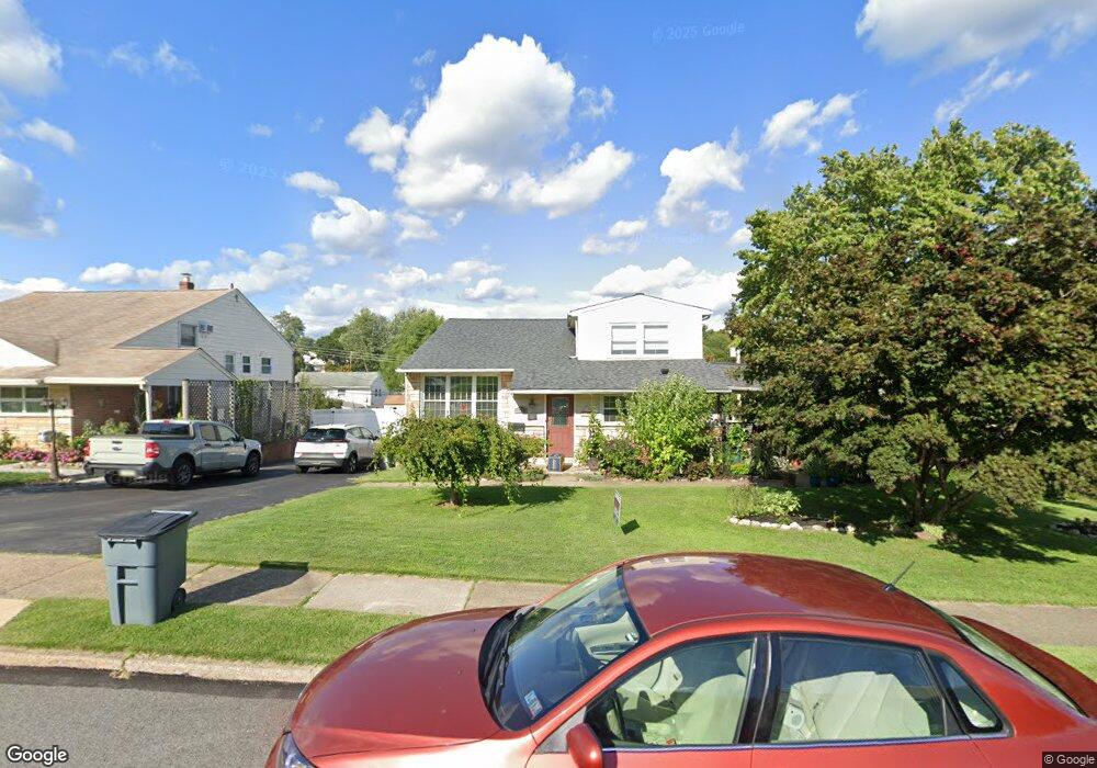
321 Robinson Dr Broomall, PA 19008
Estimated Value: $535,000 - $565,000
4
Beds
4
Baths
1,802
Sq Ft
$304/Sq Ft
Est. Value
About This Home
This home is located at 321 Robinson Dr, Broomall, PA 19008 and is currently estimated at $548,304, approximately $304 per square foot. 321 Robinson Dr is a home located in Delaware County with nearby schools including Loomis Elementary School, Paxon Hollow Middle School, and Marple Newtown Senior High School.
Ownership History
Date
Name
Owned For
Owner Type
Purchase Details
Closed on
Feb 17, 2012
Sold by
John Nancy Campo and John Michael
Bought by
John Michael and John Nancy Campo
Current Estimated Value
Home Financials for this Owner
Home Financials are based on the most recent Mortgage that was taken out on this home.
Original Mortgage
$165,000
Interest Rate
3.19%
Mortgage Type
New Conventional
Purchase Details
Closed on
Feb 19, 2003
Sold by
Giangiordano Anthony and Campo Nancy
Bought by
Campo Nancy and Jurgelewicz Michael
Home Financials for this Owner
Home Financials are based on the most recent Mortgage that was taken out on this home.
Original Mortgage
$108,000
Interest Rate
5.3%
Mortgage Type
Purchase Money Mortgage
Create a Home Valuation Report for This Property
The Home Valuation Report is an in-depth analysis detailing your home's value as well as a comparison with similar homes in the area
Home Values in the Area
Average Home Value in this Area
Purchase History
| Date | Buyer | Sale Price | Title Company |
|---|---|---|---|
| John Michael | -- | None Available | |
| Campo Nancy | $41,467 | Stewart Title Guaranty Compa |
Source: Public Records
Mortgage History
| Date | Status | Borrower | Loan Amount |
|---|---|---|---|
| Closed | John Michael | $165,000 | |
| Closed | Campo Nancy | $108,000 |
Source: Public Records
Tax History Compared to Growth
Tax History
| Year | Tax Paid | Tax Assessment Tax Assessment Total Assessment is a certain percentage of the fair market value that is determined by local assessors to be the total taxable value of land and additions on the property. | Land | Improvement |
|---|---|---|---|---|
| 2025 | $5,746 | $332,510 | $103,090 | $229,420 |
| 2024 | $5,746 | $332,510 | $103,090 | $229,420 |
| 2023 | $5,564 | $332,510 | $103,090 | $229,420 |
| 2022 | $5,458 | $332,510 | $103,090 | $229,420 |
| 2021 | $8,238 | $332,510 | $103,090 | $229,420 |
| 2020 | $4,739 | $164,680 | $53,800 | $110,880 |
| 2019 | $4,682 | $164,680 | $53,800 | $110,880 |
| 2018 | $4,633 | $164,680 | $0 | $0 |
| 2017 | $4,636 | $164,680 | $0 | $0 |
| 2016 | $904 | $164,680 | $0 | $0 |
| 2015 | $904 | $164,680 | $0 | $0 |
| 2014 | $904 | $164,680 | $0 | $0 |
Source: Public Records
Map
Nearby Homes
- 228 S Pkwy
- 416 Warren Blvd
- 407 S Central Blvd
- 429 Portland Dr
- 516 Portland Dr
- Petersburg Plan at Cedar View
- Gilfillan Plan at Cedar View
- Balvenie Plan at Cedar View
- Bowmore Plan at Cedar View
- Clayton Plan at Cedar View
- 240 N Central Blvd
- 2119 Boxwood Dr
- 631 S Central Blvd
- 306 Rock Run Cir
- 333 Sussex Blvd
- 301 S New Ardmore Ave
- 1 Brighton Village Dr
- 7 Brighton Village Dr
- 505 Glendale Rd
- 310 Lewis Rd
- 317 Robinson Dr
- 325 Robinson Dr
- 313 Robinson Dr
- 316 Warren Blvd
- 329 Robinson Dr
- 320 Warren Blvd
- 312 Warren Blvd
- 324 Robinson Dr
- 328 Robinson Dr
- 320 Robinson Dr
- 324 Warren Blvd
- 309 Robinson Dr
- 333 Robinson Dr
- 332 Robinson Dr
- 308 Warren Blvd
- 316 Robinson Dr
- 328 Warren Blvd
- 336 Robinson Dr
- 305 Robinson Dr
- 312 Robinson Dr