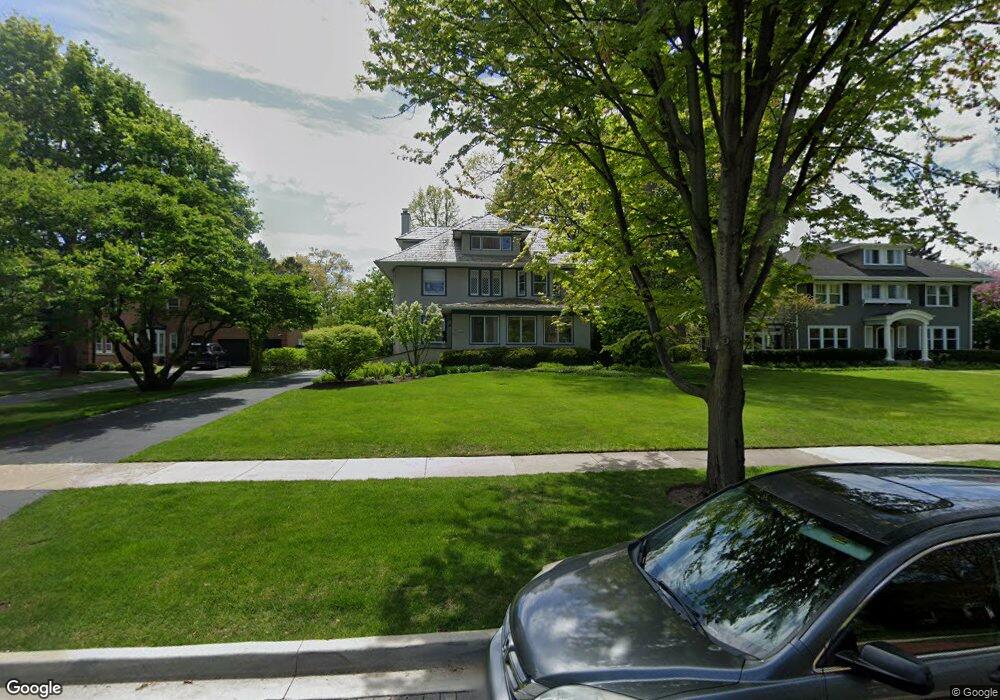
322 Warwick Rd Kenilworth, IL 60043
Estimated Value: $1,508,000 - $2,329,000
5
Beds
4
Baths
3,534
Sq Ft
$559/Sq Ft
Est. Value
About This Home
This home is located at 322 Warwick Rd, Kenilworth, IL 60043 and is currently estimated at $1,974,806, approximately $558 per square foot. 322 Warwick Rd is a home located in Cook County with nearby schools including The Joseph Sears School, New Trier Township High School, and New Trier Township High School - Northfield.
Ownership History
Date
Name
Owned For
Owner Type
Purchase Details
Closed on
Mar 18, 1997
Sold by
Lasalle National Bank
Bought by
Weiss John R and Weiss Elizabeth Z
Current Estimated Value
Home Financials for this Owner
Home Financials are based on the most recent Mortgage that was taken out on this home.
Original Mortgage
$649,000
Outstanding Balance
$64,312
Interest Rate
5.62%
Estimated Equity
$1,910,494
Create a Home Valuation Report for This Property
The Home Valuation Report is an in-depth analysis detailing your home's value as well as a comparison with similar homes in the area
Home Values in the Area
Average Home Value in this Area
Purchase History
| Date | Buyer | Sale Price | Title Company |
|---|---|---|---|
| Weiss John R | $902,500 | -- |
Source: Public Records
Mortgage History
| Date | Status | Borrower | Loan Amount |
|---|---|---|---|
| Open | Weiss John R | $649,000 |
Source: Public Records
Tax History Compared to Growth
Tax History
| Year | Tax Paid | Tax Assessment Tax Assessment Total Assessment is a certain percentage of the fair market value that is determined by local assessors to be the total taxable value of land and additions on the property. | Land | Improvement |
|---|---|---|---|---|
| 2024 | $32,616 | $133,000 | $40,530 | $92,470 |
| 2023 | $30,619 | $133,000 | $40,530 | $92,470 |
| 2022 | $30,619 | $133,000 | $40,530 | $92,470 |
| 2021 | $34,007 | $118,508 | $29,722 | $88,786 |
| 2020 | $33,052 | $118,508 | $29,722 | $88,786 |
| 2019 | $32,028 | $130,229 | $29,722 | $100,507 |
| 2018 | $29,104 | $116,386 | $25,669 | $90,717 |
| 2017 | $28,259 | $116,386 | $25,669 | $90,717 |
| 2016 | $28,731 | $124,412 | $25,669 | $98,743 |
| 2015 | $30,013 | $114,803 | $20,940 | $93,863 |
| 2014 | $29,241 | $114,803 | $20,940 | $93,863 |
| 2013 | $27,550 | $114,803 | $20,940 | $93,863 |
Source: Public Records
Map
Nearby Homes
- 321 Leicester Rd
- 330 Abbotsford Rd
- 141 Kenilworth Ave
- 527 Warwick Rd
- 528 Roslyn Rd
- 530 Essex Rd
- 54 Kenilworth Ave
- 517 Cumnor Rd
- 303 Sheridan Rd
- 1120 Chestnut Ave
- 643 Abbotsford Rd
- 507 Kenilworth Ave
- 1630 Sheridan Rd Unit 5K
- 1630 Sheridan Rd Unit 2F
- 1630 Sheridan Rd Unit 8K
- 1630 Sheridan Rd Unit 2N
- 1630 Sheridan Rd Unit 3C
- 1630 Sheridan Rd Unit 4M
- 1630 Sheridan Rd Unit 2J
- 1416 Elmwood Ave
- 328 Warwick Rd
- 310 Warwick Rd
- 336 Warwick Rd
- 319 Essex Rd
- 300 Warwick Rd
- 331 Essex Rd
- 315 Essex Rd
- 321 Warwick Rd
- 329 Warwick Rd
- 337 Essex Rd
- 315 Warwick Rd
- 257 Woodstock Ave
- 240 Kenilworth Ave
- 221 Woodstock Ave
- 256 Kenilworth Ave
- 240 Woodstock Ave
- 320 Leicester Rd
- 328 Leicester Rd
- 256 Woodstock Ave
- 312 Leicester Rd