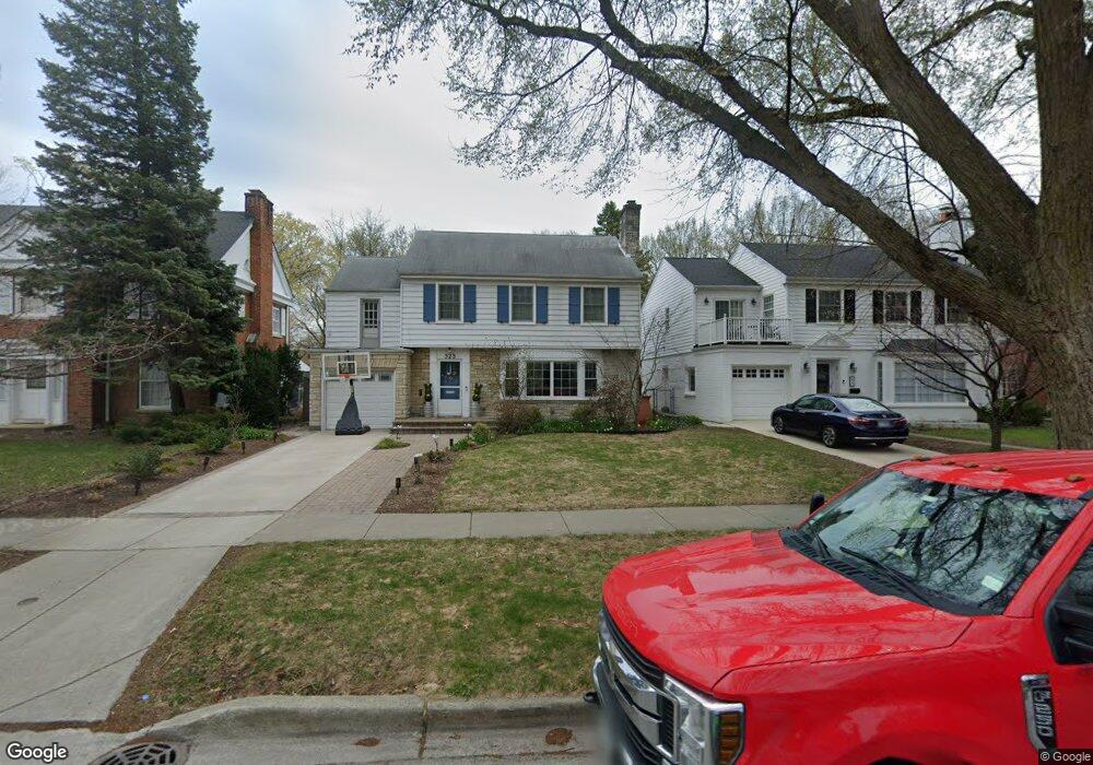
323 Ashland Ave Evanston, IL 60202
Estimated Value: $756,000 - $949,000
4
Beds
3
Baths
3,013
Sq Ft
$278/Sq Ft
Est. Value
About This Home
This home is located at 323 Ashland Ave, Evanston, IL 60202 and is currently estimated at $837,397, approximately $277 per square foot. 323 Ashland Ave is a home located in Cook County with nearby schools including Dawes Elementary School, Chute Middle School, and Evanston Township High School.
Ownership History
Date
Name
Owned For
Owner Type
Purchase Details
Closed on
Jun 30, 2009
Sold by
Fink Jack P and Fink Florence W
Bought by
Collins Christopher and Courrier Danielle
Current Estimated Value
Home Financials for this Owner
Home Financials are based on the most recent Mortgage that was taken out on this home.
Original Mortgage
$382,500
Outstanding Balance
$253,547
Interest Rate
5.62%
Mortgage Type
Unknown
Estimated Equity
$583,850
Create a Home Valuation Report for This Property
The Home Valuation Report is an in-depth analysis detailing your home's value as well as a comparison with similar homes in the area
Home Values in the Area
Average Home Value in this Area
Purchase History
| Date | Buyer | Sale Price | Title Company |
|---|---|---|---|
| Collins Christopher | $425,000 | First American Title Ins Co |
Source: Public Records
Mortgage History
| Date | Status | Borrower | Loan Amount |
|---|---|---|---|
| Open | Collins Christopher | $382,500 |
Source: Public Records
Tax History Compared to Growth
Tax History
| Year | Tax Paid | Tax Assessment Tax Assessment Total Assessment is a certain percentage of the fair market value that is determined by local assessors to be the total taxable value of land and additions on the property. | Land | Improvement |
|---|---|---|---|---|
| 2024 | $14,885 | $64,001 | $14,108 | $49,893 |
| 2023 | $14,254 | $64,001 | $14,108 | $49,893 |
| 2022 | $14,254 | $64,001 | $14,108 | $49,893 |
| 2021 | $12,480 | $49,734 | $10,260 | $39,474 |
| 2020 | $12,955 | $51,935 | $10,260 | $41,675 |
| 2019 | $12,960 | $58,028 | $10,260 | $47,768 |
| 2018 | $12,341 | $47,888 | $8,550 | $39,338 |
| 2017 | $12,033 | $47,888 | $8,550 | $39,338 |
| 2016 | $11,635 | $47,888 | $8,550 | $39,338 |
| 2015 | $11,159 | $43,657 | $7,053 | $36,604 |
| 2014 | $11,067 | $43,657 | $7,053 | $36,604 |
| 2013 | $10,795 | $43,657 | $7,053 | $36,604 |
Source: Public Records
Map
Nearby Homes
- 347 Florence Ave
- 419 Florence Ave
- 1217 Hull Terrace Unit 3A
- 1214 Hull Terrace
- 401 Dewey Ave
- 1406 Brummel St
- 309 Darrow Ave
- 1408 Seward St
- 325 Dodge Ave
- 1810 South Blvd
- 1200 Dobson St
- 1615 W Howard St Unit 303
- 340 Ridge Ave Unit 1
- 400 Ridge Ave Unit 16-2
- 356 Ridge Ave Unit 6-2
- 553 Barton Ave
- 1726 Dobson St
- 1021 South Blvd
- 215 Brown Ave
- 647 Asbury Ave
- 321 Ashland Ave
- 315 Ashland Ave
- 331 Ashland Ave
- 333 Ashland Ave
- 309 Ashland Ave
- 320 Wesley Ave
- 337 Ashland Ave
- 316 Wesley Ave
- 324 Wesley Ave
- 305 Ashland Ave
- 312 Wesley Ave
- 310 Wesley Ave
- 322 Ashland Ave
- 328 Wesley Ave
- 326 Ashland Ave
- 334 Wesley Ave
- 318 Ashland Ave
- 330 Wesley Ave
- 336 Wesley Ave
- 332 Wesley Ave