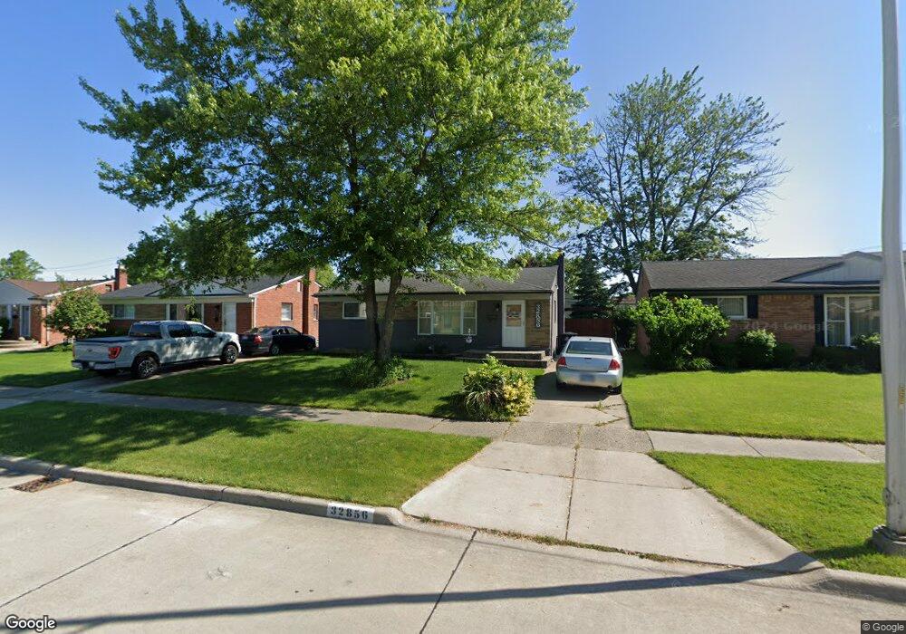
32856 Merritt Dr Westland, MI 48185
Estimated Value: $211,862 - $277,000
--
Bed
1
Bath
1,055
Sq Ft
$237/Sq Ft
Est. Value
About This Home
This home is located at 32856 Merritt Dr, Westland, MI 48185 and is currently estimated at $249,716, approximately $236 per square foot. 32856 Merritt Dr is a home located in Wayne County with nearby schools including Hayes Elementary School, Cooper Upper Elementary School, and Emerson Middle School.
Ownership History
Date
Name
Owned For
Owner Type
Purchase Details
Closed on
Mar 23, 2005
Sold by
Waitr Gerry Ann and Gerry Ann Waitr Revocable Trus
Bought by
Waitr Gerry Ann
Current Estimated Value
Home Financials for this Owner
Home Financials are based on the most recent Mortgage that was taken out on this home.
Original Mortgage
$60,704
Interest Rate
7.5%
Mortgage Type
New Conventional
Create a Home Valuation Report for This Property
The Home Valuation Report is an in-depth analysis detailing your home's value as well as a comparison with similar homes in the area
Home Values in the Area
Average Home Value in this Area
Purchase History
| Date | Buyer | Sale Price | Title Company |
|---|---|---|---|
| Waitr Gerry Ann | -- | -- |
Source: Public Records
Mortgage History
| Date | Status | Borrower | Loan Amount |
|---|---|---|---|
| Closed | Waitr Gerry Ann | $60,704 |
Source: Public Records
Tax History Compared to Growth
Tax History
| Year | Tax Paid | Tax Assessment Tax Assessment Total Assessment is a certain percentage of the fair market value that is determined by local assessors to be the total taxable value of land and additions on the property. | Land | Improvement |
|---|---|---|---|---|
| 2025 | $1,971 | $105,900 | $0 | $0 |
| 2024 | $1,971 | $98,700 | $0 | $0 |
| 2023 | $1,882 | $89,600 | $0 | $0 |
| 2022 | $2,197 | $77,800 | $0 | $0 |
| 2021 | $2,142 | $74,200 | $0 | $0 |
| 2020 | $2,119 | $70,400 | $0 | $0 |
| 2019 | $2,020 | $68,200 | $0 | $0 |
| 2018 | $1,589 | $56,000 | $0 | $0 |
| 2017 | $738 | $52,200 | $0 | $0 |
| 2016 | $1,919 | $52,600 | $0 | $0 |
| 2015 | $3,596 | $45,880 | $0 | $0 |
| 2013 | $3,484 | $35,600 | $0 | $0 |
| 2012 | $1,607 | $35,670 | $0 | $0 |
Source: Public Records
Map
Nearby Homes
- 33211 Anita Dr
- 32725 Joy Rd
- 32724 Hees St
- 32451 Sandra Ln
- 7946 Moonwood Place
- 9243 Montana St
- 33312 Lynx St
- 32327 Washington St
- 32047 Anita Dr
- 33030 Cowan Rd
- 33632 Cindy St
- 7436 Cochise St
- 8824 Nevada St
- 32611 Vermont St
- 8332 Berwick Dr
- 9668 Farmington Rd
- 9212 Idaho St
- 7872 Ritz Ave
- 9253 Idaho St
- 8219 Roselawn St
- 32864 Merritt Dr
- 32848 Merritt Dr
- 32872 Merritt Dr
- 32840 Merritt Dr
- 32881 Mackenzie Dr
- 32871 Mackenzie Dr
- 32891 Mackenzie Dr
- 32861 Mackenzie Dr
- 32880 Merritt Dr Unit Bldg-Unit
- 32880 Merritt Dr
- 32832 Merritt Dr
- 32899 Mackenzie Dr
- 32861 Merritt Dr
- 32851 Mackenzie Dr
- 33001 Mackenzie Dr
- 32888 Merritt Dr
- 32824 Merritt Dr
- 32873 Merritt Dr Unit Bldg-Unit
- 32873 Merritt Dr
- 32845 Merritt Dr