Estimated Value: $571,000 - $780,000
2
Beds
1
Bath
2,105
Sq Ft
$312/Sq Ft
Est. Value
About This Home
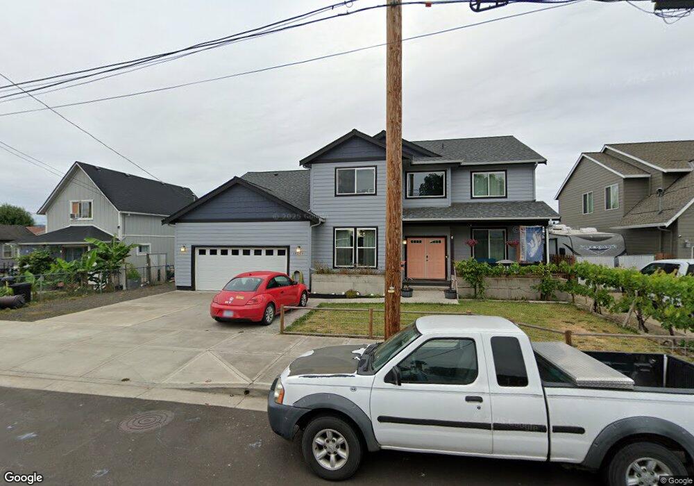
This home is located at 331 Park St, Banks, OR 97106 and is currently estimated at $656,225, approximately $311 per square foot. 331 Park St is a home located in Washington County with nearby schools including Banks Elementary School, Banks Middle School, and Banks High School.
Ownership History
Date
Name
Owned For
Owner Type
Purchase Details
Closed on
Feb 19, 2020
Sold by
Bales Katherine A and Patty S King Living Trust
Bought by
Richeson Anthony and Richeson Kiley
Current Estimated Value
Home Financials for this Owner
Home Financials are based on the most recent Mortgage that was taken out on this home.
Original Mortgage
$366,035
Outstanding Balance
$325,766
Interest Rate
3.6%
Mortgage Type
Construction
Estimated Equity
$330,459
Purchase Details
Closed on
Jul 3, 2013
Sold by
King Patty Sue
Bought by
King Patty S
Create a Home Valuation Report for This Property
The Home Valuation Report is an in-depth analysis detailing your home's value as well as a comparison with similar homes in the area
Home Values in the Area
Average Home Value in this Area
Purchase History
| Date | Buyer | Sale Price | Title Company |
|---|---|---|---|
| Richeson Anthony | -- | Old Republic Title | |
| King Patty S | -- | None Available |
Source: Public Records
Mortgage History
| Date | Status | Borrower | Loan Amount |
|---|---|---|---|
| Open | Richeson Anthony | $366,035 |
Source: Public Records
Tax History Compared to Growth
Tax History
| Year | Tax Paid | Tax Assessment Tax Assessment Total Assessment is a certain percentage of the fair market value that is determined by local assessors to be the total taxable value of land and additions on the property. | Land | Improvement |
|---|---|---|---|---|
| 2025 | $6,246 | $339,980 | -- | -- |
| 2024 | $5,677 | $330,080 | -- | -- |
| 2023 | $5,677 | $320,470 | $0 | $0 |
| 2022 | $5,527 | $320,470 | $0 | $0 |
| 2021 | $3,305 | $187,260 | $0 | $0 |
| 2020 | $2,754 | $156,130 | $0 | $0 |
| 2019 | $2,644 | $151,590 | $0 | $0 |
| 2018 | $2,573 | $147,180 | $0 | $0 |
| 2017 | $2,464 | $142,900 | $0 | $0 |
| 2016 | $2,426 | $138,740 | $0 | $0 |
| 2015 | $2,331 | $134,700 | $0 | $0 |
| 2014 | $2,297 | $130,780 | $0 | $0 |
Source: Public Records
Map
Nearby Homes
- 12874 NW Maplecrest Way
- 42371 NW Banks Rd
- 12838 NW Maplecrest Way
- 0 NW Sellers Rd
- 12734 NW Hammond Place
- 42015 NW Buckshire St
- 42098 NW Broadshire Ln
- 43300 NW Cedar Canyon Rd
- 41710 NW Oak Way
- 41753 NW Buckshire St
- 41637 NW Buckshire St
- 0 NW Lodge Rd
- 48025 NW Strohmayer Rd
- 0 NW Green Mountain Rd Unit 1 23320324
- 0 NW Green Mountain Rd Unit 24253646
- 46345 NW Strohmayer Rd
- 18282 NW Hilltop Place
- 11911 NW Seavey Rd
- 45868 NW Hillside Rd
- 21076 NW Green Mountain Rd