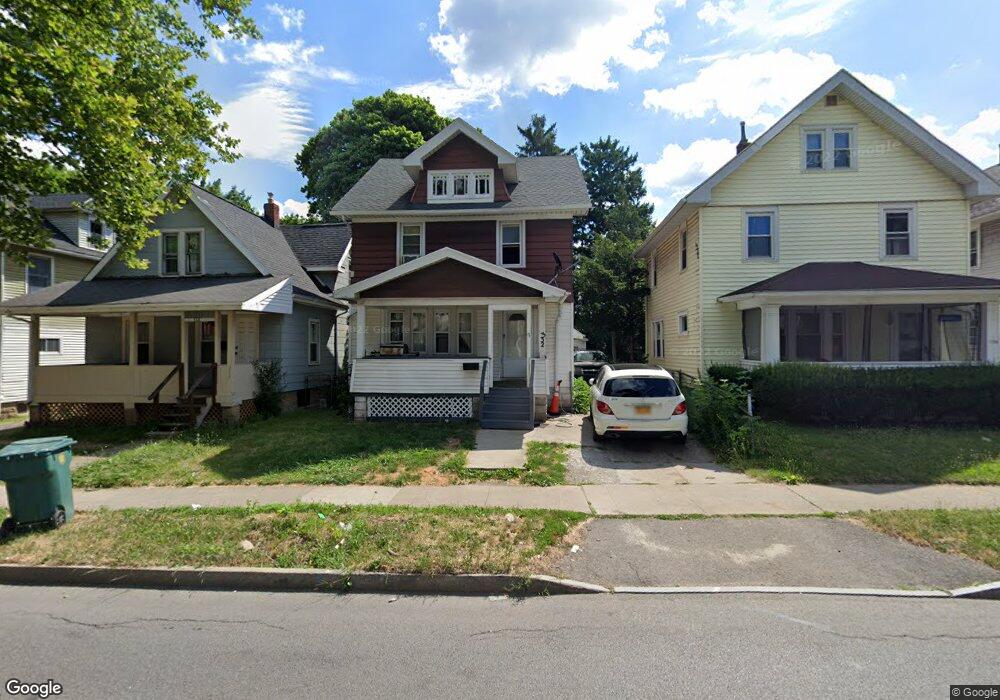
332 Carter St Rochester, NY 14621
Northeast Rochester NeighborhoodEstimated Value: $108,675 - $118,000
3
Beds
1
Bath
1,252
Sq Ft
$90/Sq Ft
Est. Value
About This Home
This home is located at 332 Carter St, Rochester, NY 14621 and is currently estimated at $112,919, approximately $90 per square foot. 332 Carter St is a home located in Monroe County with nearby schools including School 39-Andrew J. Townson, Mary McLeod Bethune School No. 45, and School 25 Nathaniel Hawthorne.
Ownership History
Date
Name
Owned For
Owner Type
Purchase Details
Closed on
Feb 11, 2021
Sold by
Aguglia Theodore E and The Aguglia Family Trust
Bought by
Kesstal Llc
Current Estimated Value
Purchase Details
Closed on
Jan 4, 2011
Sold by
Aguglia Theodore E
Bought by
Aguglia Theodore E
Purchase Details
Closed on
Jul 7, 2009
Sold by
Aguglia Theodore E and Gardner Michael S
Bought by
Aguglia Theodore E
Purchase Details
Closed on
Aug 17, 1998
Purchase Details
Closed on
May 13, 1998
Sold by
Singla Rameshwar Raj
Bought by
Aguglia Theodore E
Create a Home Valuation Report for This Property
The Home Valuation Report is an in-depth analysis detailing your home's value as well as a comparison with similar homes in the area
Home Values in the Area
Average Home Value in this Area
Purchase History
| Date | Buyer | Sale Price | Title Company |
|---|---|---|---|
| Kesstal Llc | $29,000 | Network Title Agcy Of Ny Llc | |
| Kesstai Llc | $29,000 | Network Title | |
| Aguglia Theodore E | -- | None Available | |
| Aguglia Theodore E | -- | None Available | |
| -- | -- | -- | |
| Aguglia Theodore E | $25,000 | -- |
Source: Public Records
Tax History Compared to Growth
Tax History
| Year | Tax Paid | Tax Assessment Tax Assessment Total Assessment is a certain percentage of the fair market value that is determined by local assessors to be the total taxable value of land and additions on the property. | Land | Improvement |
|---|---|---|---|---|
| 2024 | $677 | $80,100 | $8,300 | $71,800 |
| 2023 | $412 | $38,000 | $3,800 | $34,200 |
| 2022 | $424 | $38,000 | $3,800 | $34,200 |
| 2021 | $462 | $38,000 | $3,800 | $34,200 |
| 2020 | $568 | $38,000 | $3,800 | $34,200 |
| 2019 | $556 | $38,500 | $3,800 | $34,700 |
| 2018 | $1,320 | $38,500 | $3,800 | $34,700 |
| 2017 | $0 | $38,500 | $3,800 | $34,700 |
| 2016 | $556 | $38,500 | $3,800 | $34,700 |
| 2015 | $1,322 | $37,600 | $3,800 | $33,800 |
| 2014 | $1,322 | $37,600 | $3,800 | $33,800 |
Source: Public Records
Map
Nearby Homes
- 319 Carter St
- 318-320 Durnan St
- 187-189 Delamaine Dr
- 120 Barberry Terrace
- 199 Roycroft Dr
- 152 Delamaine Dr
- 146 Delamaine Dr
- 165 Durnan St
- 83 Holbrooke St
- 1303 North St
- 164 Herald St
- 50 Manchester St
- 1191 North St
- 92 Roycroft Dr
- 125-127 Carter St Unit 125
- 212 Saint Stanislaus St
- 77 Roycroft Dr
- 96 Sobieski St
- 88 Rosemary Dr
- 212 Lux St
- 338 Carter St
- 326 Carter St
- 340 Carter St
- 292 Durnan St
- 318 Carter St Unit 320
- 342 Carter St Unit 344
- 296 Durnan St
- 302 Durnan St
- 331 Carter St
- 356 Carter St
- 308 Carter St
- 335 Carter St
- 187 Barberry Terrace
- 308 Durnan St
- 291 Durnan St
- 302 Carter St
- 259 Durnan St
- 295 Durnan St
- 345 Carter St Unit 347
- 252 Durnan St