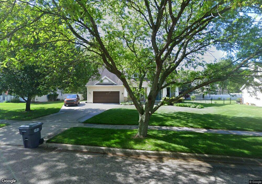
335 Brittany Dr Portage, MI 49024
Estimated Value: $393,000 - $466,000
3
Beds
3
Baths
2,102
Sq Ft
$206/Sq Ft
Est. Value
About This Home
This home is located at 335 Brittany Dr, Portage, MI 49024 and is currently estimated at $432,250, approximately $205 per square foot. 335 Brittany Dr is a home located in Kalamazoo County with nearby schools including Central Elementary School, Portage Central Middle School, and Portage Central High School.
Ownership History
Date
Name
Owned For
Owner Type
Purchase Details
Closed on
Jul 11, 2023
Sold by
Mills Daniel J and Mills Theresa K
Bought by
Daniel J And Theresa K Mills Trust and Mills
Current Estimated Value
Purchase Details
Closed on
Dec 10, 2004
Sold by
Vliek Ted W and Joyce Vliek A
Bought by
Mills Daniel J and Mills Theresa Kay
Home Financials for this Owner
Home Financials are based on the most recent Mortgage that was taken out on this home.
Original Mortgage
$235,000
Interest Rate
5.77%
Mortgage Type
Purchase Money Mortgage
Create a Home Valuation Report for This Property
The Home Valuation Report is an in-depth analysis detailing your home's value as well as a comparison with similar homes in the area
Home Values in the Area
Average Home Value in this Area
Purchase History
| Date | Buyer | Sale Price | Title Company |
|---|---|---|---|
| Daniel J And Theresa K Mills Trust | -- | None Listed On Document | |
| Mills Daniel J | $41,000 | Devon |
Source: Public Records
Mortgage History
| Date | Status | Borrower | Loan Amount |
|---|---|---|---|
| Previous Owner | Mills Daniel J | $235,000 |
Source: Public Records
Tax History Compared to Growth
Tax History
| Year | Tax Paid | Tax Assessment Tax Assessment Total Assessment is a certain percentage of the fair market value that is determined by local assessors to be the total taxable value of land and additions on the property. | Land | Improvement |
|---|---|---|---|---|
| 2025 | $6,195 | $201,200 | $0 | $0 |
| 2024 | $5,453 | $193,600 | $0 | $0 |
| 2023 | $5,198 | $168,700 | $0 | $0 |
| 2022 | $5,617 | $150,200 | $0 | $0 |
| 2021 | $5,429 | $145,300 | $0 | $0 |
| 2020 | $5,310 | $135,600 | $0 | $0 |
| 2019 | $478 | $130,300 | $0 | $0 |
| 2018 | $0 | $130,700 | $0 | $0 |
| 2017 | $0 | $129,200 | $0 | $0 |
| 2016 | -- | $131,600 | $0 | $0 |
| 2015 | -- | $121,100 | $0 | $0 |
| 2014 | -- | $111,400 | $0 | $0 |
Source: Public Records
Map
Nearby Homes
- 9766 S Westnedge Ave
- 10010 Lloy St
- 9625 Oakview Dr
- 404 Pimlico Ct
- 9744 Chambray St
- 442 Pinewood Cir
- 341 Cliffwood Ave
- 550 Ludington Ave
- 580 Ludington Ave
- 811 Anchor Ln
- 721 Briella Ct
- 775 Chloe Jane Ave
- 739 Chloe Jane Ave
- 10545 Sharon Lee Ln
- 729 Chloe Jane Ave
- 735 Briella Ct
- 10631 Gracie Ln Unit 6
- 981 Coral Springs Dr Unit 2
- 1035 Coral Springs Dr Unit 4
- 741 Calico Ave
- 367 Brittany Dr
- 305 Brittany Dr
- 334 Tuscany Dr
- 7384 Brittany Dr
- 364 Tuscany Dr
- 304 Tuscany Dr
- 397 Brittany Dr
- 273 Brittany Dr
- 358 Brittany Dr
- 296 Brittany Dr
- 394 Tuscany Dr
- 270 Tuscany Dr
- 390 Brittany Dr
- 425 Brittany Dr
- 264 Brittany Dr
- 424 Tuscany Dr
- 331 Aldersgate Dr
- 333 Tuscany Dr
- 420 Brittany Dr
- 361 Aldersgate Dr