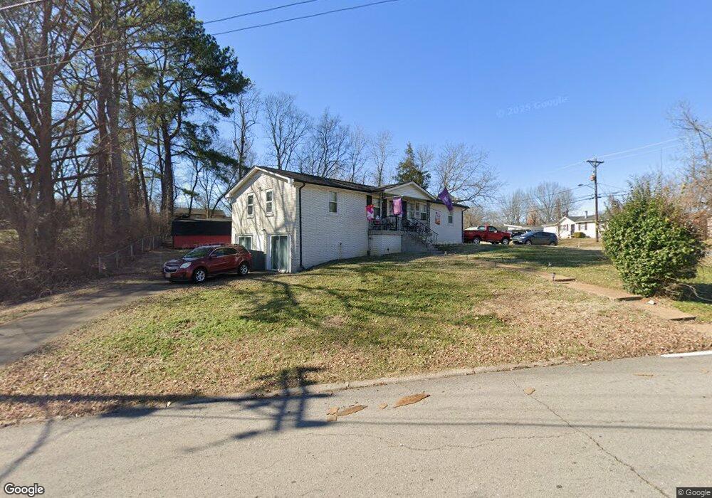
337 Bart Dr Antioch, TN 37013
Fairlane NeighborhoodEstimated Value: $366,000 - $472,000
3
Beds
2
Baths
2,950
Sq Ft
$140/Sq Ft
Est. Value
About This Home
This home is located at 337 Bart Dr, Antioch, TN 37013 and is currently estimated at $413,139, approximately $140 per square foot. 337 Bart Dr is a home located in Davidson County with nearby schools including Cole Elementary School, Antioch Middle School, and Cane Ridge High School.
Ownership History
Date
Name
Owned For
Owner Type
Purchase Details
Closed on
Dec 1, 2015
Sold by
Slayden Howard T and Cawthon Donna
Bought by
Slayden Robert Christopher
Current Estimated Value
Home Financials for this Owner
Home Financials are based on the most recent Mortgage that was taken out on this home.
Original Mortgage
$80,000
Interest Rate
3.91%
Mortgage Type
Unknown
Purchase Details
Closed on
Jul 8, 2009
Sold by
Slayden Howard T and Slayden Beverly Ann
Bought by
Slayden Robert Christopher and Slayden Howard T
Create a Home Valuation Report for This Property
The Home Valuation Report is an in-depth analysis detailing your home's value as well as a comparison with similar homes in the area
Home Values in the Area
Average Home Value in this Area
Purchase History
| Date | Buyer | Sale Price | Title Company |
|---|---|---|---|
| Slayden Robert Christopher | -- | Bridgehouse Title | |
| Slayden Robert Christopher | -- | None Available |
Source: Public Records
Mortgage History
| Date | Status | Borrower | Loan Amount |
|---|---|---|---|
| Closed | Slayden Robert Christopher | $80,000 |
Source: Public Records
Tax History Compared to Growth
Tax History
| Year | Tax Paid | Tax Assessment Tax Assessment Total Assessment is a certain percentage of the fair market value that is determined by local assessors to be the total taxable value of land and additions on the property. | Land | Improvement |
|---|---|---|---|---|
| 2024 | $2,486 | $76,400 | $11,250 | $65,150 |
| 2023 | $2,486 | $76,400 | $11,250 | $65,150 |
| 2022 | $2,486 | $76,400 | $11,250 | $65,150 |
| 2021 | $2,512 | $76,400 | $11,250 | $65,150 |
| 2020 | $2,349 | $55,650 | $7,500 | $48,150 |
| 2019 | $1,756 | $55,650 | $7,500 | $48,150 |
| 2018 | $1,756 | $55,650 | $7,500 | $48,150 |
| 2017 | $1,756 | $55,650 | $7,500 | $48,150 |
| 2016 | $1,497 | $33,150 | $4,250 | $28,900 |
| 2015 | $1,497 | $33,150 | $4,250 | $28,900 |
| 2014 | $1,497 | $33,150 | $4,250 | $28,900 |
Source: Public Records
Map
Nearby Homes
- 716 Muskhogean Ct
- 304 Jenny Murff Dr
- 4985 Shihmen Dr
- 121 Tomarand Rd
- 90 Tusculum Rd
- 73 Tusculum Rd
- 4876 Cimarron Way
- 1148 Brittany Park Ln
- 1140 Brittany Park Ln
- 5001 Mclendon Dr
- 5057 Mclendon Dr
- 4916 Olivia Dr
- 220 Brittany Park Cir
- 4712 Arapaho Bend
- 206 Brittany Park Cir
- 125 Robert Yoest Dr
- 161 Tusculum Rd
- 4101 Eastview Dr
- 1345 Bell Rd Unit 412
- 1345 Bell Rd Unit 425