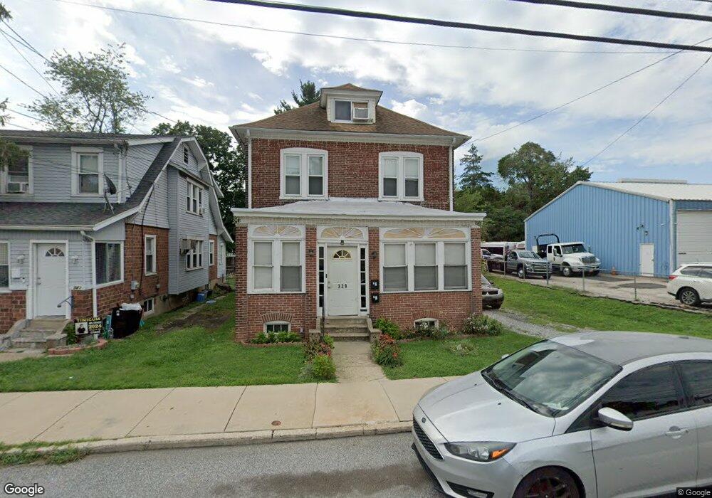
339 S Governor Printz Blvd Essington, PA 19029
Estimated Value: $274,931 - $333,000
4
Beds
2
Baths
1,632
Sq Ft
$185/Sq Ft
Est. Value
About This Home
This home is located at 339 S Governor Printz Blvd, Essington, PA 19029 and is currently estimated at $301,733, approximately $184 per square foot. 339 S Governor Printz Blvd is a home located in Delaware County with nearby schools including Interboro Senior High School and St James Regional Catholic School.
Ownership History
Date
Name
Owned For
Owner Type
Purchase Details
Closed on
Nov 30, 2004
Sold by
Faix Robert O and Faix Charles
Bought by
Cicconi Land Corp
Current Estimated Value
Home Financials for this Owner
Home Financials are based on the most recent Mortgage that was taken out on this home.
Original Mortgage
$132,800
Interest Rate
4.99%
Mortgage Type
Fannie Mae Freddie Mac
Create a Home Valuation Report for This Property
The Home Valuation Report is an in-depth analysis detailing your home's value as well as a comparison with similar homes in the area
Home Values in the Area
Average Home Value in this Area
Purchase History
| Date | Buyer | Sale Price | Title Company |
|---|---|---|---|
| Cicconi Land Corp | $166,000 | -- |
Source: Public Records
Mortgage History
| Date | Status | Borrower | Loan Amount |
|---|---|---|---|
| Closed | Cicconi Land Corp | $132,800 |
Source: Public Records
Tax History Compared to Growth
Tax History
| Year | Tax Paid | Tax Assessment Tax Assessment Total Assessment is a certain percentage of the fair market value that is determined by local assessors to be the total taxable value of land and additions on the property. | Land | Improvement |
|---|---|---|---|---|
| 2025 | $4,803 | $151,940 | $35,760 | $116,180 |
| 2024 | $4,803 | $151,940 | $35,760 | $116,180 |
| 2023 | $4,723 | $151,940 | $35,760 | $116,180 |
| 2022 | $4,635 | $151,940 | $35,760 | $116,180 |
| 2021 | $6,866 | $151,940 | $35,760 | $116,180 |
| 2020 | $4,628 | $98,390 | $25,530 | $72,860 |
| 2019 | $4,621 | $98,390 | $25,530 | $72,860 |
| 2018 | $4,530 | $98,390 | $0 | $0 |
| 2017 | $4,420 | $98,390 | $0 | $0 |
| 2016 | $540 | $98,390 | $0 | $0 |
| 2015 | $551 | $98,390 | $0 | $0 |
| 2014 | $540 | $98,390 | $0 | $0 |
Source: Public Records
Map
Nearby Homes
- 210 Powhattan Ave
- 436 Manhattan St
- 125 S Governor Printz Blvd
- 307 Jansen Ave
- 231 Bartram Ave
- 229 Saude Ave
- 69 Martin Ln
- 536 E Winona Ave
- 120 Bartram Ave
- 207 Carre Ave
- 403 Printz Ave
- 1062 Taylor Dr
- 508 E Winona Ave
- 512 Essex Rd
- 1158 Taylor Dr
- 20 Martin Ln
- 952 Grant Rd
- 810 Bennington Rd
- 1946 Carter Rd
- 784 Bennington Rd
- 341 S Governor Printz Blvd
- 343 S Governor Printz Blvd
- 345 S Governor Printz Blvd
- 336 Powhattan St
- 322 Powhattan St
- 322 Powhattan Ave
- 324 Powhattan St
- 324 Powhattan Ave
- 326 Powhattan St
- 334 Powhattan St
- 344 Powhattan Ave
- 344 Powhattan Ave
- 326 Powhattan Ave
- 338 S Governor Printz Blvd
- 637 Pontiac St
- 330 S Governor Printz Blvd
- 312 Powhattan Ave
- 312 Powhattan St
- 817 4th Ave
- 815 4th Ave Unit 3