
34 Appe Ln Whitehall, MT 59759
Estimated payment $1,468/month
Highlights
- Horses Allowed On Property
- Bluff on Lot
- Spring on Lot
- Views of Trees
- Secluded Lot
- Wooded Lot
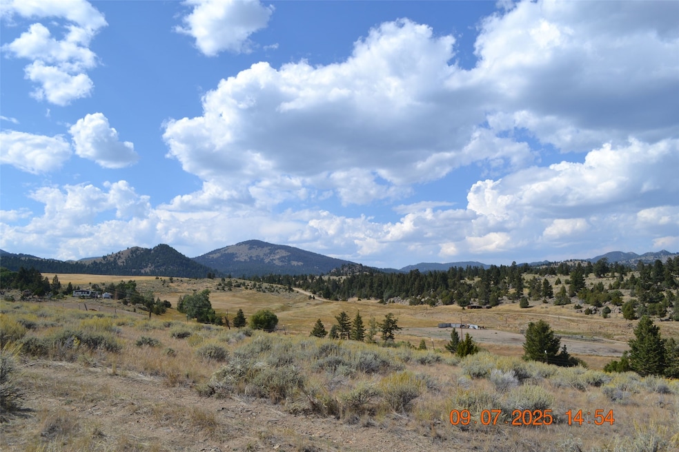
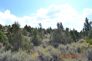
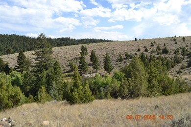
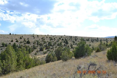
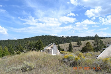
About This Lot
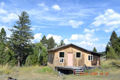
A little over 21 acres with county road access. Many level building sites with 360 views of Tobacco Root, Highlands and Bull Mountains. Power to the property. Varying ground from flat sagebrush to tree covered slopes. A rough cabin is on the property and can be used with a lot of TLC. 14 miles to I-90 access and Butte and only 15 miles to Whitehall, close to town but country living. Good phone coverage in area (verizon).
Property Details
Property Type
- Land
Est. Annual Taxes
- $930
Lot Details
- 21.05 Acre Lot
- Property fronts a private road
- Property fronts a county road
- Bluff on Lot
- Secluded Lot
- Gentle Sloping Lot
- Wooded Lot
Property Views
- Trees
- Mountain
- Valley
Additional Features
- Horses Allowed On Property
- Water Not Available
Listing and Financial Details
- Assessor Parcel Number 51099522101050000
Community Details
Overview
- No Home Owners Association
Recreation
- Spring on Lot
Map
Home Values in the Area
Average Home Value in this Area
Tax History
| Year | Tax Paid | Tax Assessment Tax Assessment Total Assessment is a certain percentage of the fair market value that is determined by local assessors to be the total taxable value of land and additions on the property. | Land | Improvement |
|---|---|---|---|---|
| 2025 | $686 | $100,571 | $0 | $0 |
| 2024 | $660 | $69,244 | $0 | $0 |
| 2023 | $690 | $69,244 | $0 | $0 |
| 2022 | $614 | $49,590 | $0 | $0 |
| 2021 | $405 | $49,590 | $0 | $0 |
| 2020 | $579 | $47,213 | $0 | $0 |
| 2019 | $565 | $47,213 | $0 | $0 |
| 2018 | $542 | $43,499 | $0 | $0 |
| 2017 | $463 | $38,209 | $0 | $0 |
| 2016 | $430 | $35,593 | $0 | $0 |
| 2015 | $294 | $35,593 | $0 | $0 |
| 2014 | $332 | $22,092 | $0 | $0 |
Property History
| Date | Event | Price | List to Sale | Price per Sq Ft | Prior Sale |
|---|---|---|---|---|---|
| 09/08/2025 09/08/25 | For Sale | $265,000 | +12.8% | -- | |
| 01/08/2025 01/08/25 | Sold | -- | -- | -- | View Prior Sale |
| 12/06/2024 12/06/24 | Pending | -- | -- | -- | |
| 10/03/2024 10/03/24 | Price Changed | $235,000 | -11.3% | $326 / Sq Ft | |
| 08/07/2024 08/07/24 | For Sale | $265,000 | -- | $368 / Sq Ft |
Purchase History
| Date | Type | Sale Price | Title Company |
|---|---|---|---|
| Quit Claim Deed | -- | Rocky Mountain Title | |
| Warranty Deed | -- | Rocky Mountain Title | |
| Warranty Deed | -- | Rocky Mountain Title | |
| Warranty Deed | -- | None Available |
Source: Montana Regional MLS
MLS Number: 30057208
APN: 51-0995-22-1-01-05-0000
Disclaimer: Certain information contained herein is derived from information provided by parties other than Homes.com. All information provided is deemed reliable, but is not guaranteed to be accurate and should be independently verified.
![]() IDX information is provided exclusively for personal, non-commercial use, and may not be used for any purpose other than to identify prospective properties consumers may be interested in purchasing. Information is deemed reliable but not guaranteed.
IDX information is provided exclusively for personal, non-commercial use, and may not be used for any purpose other than to identify prospective properties consumers may be interested in purchasing. Information is deemed reliable but not guaranteed.
- TBD Cedar Hills Rd
- TBD Grace Rd
- 136 Lost Moose Bend Rd
- 11 Lost Moose Bend
- 967 Mt Highway 2 W
- 180 Lower Rader Creek Rd
- 91 Upper Radar Creek Rd
- tbd Upper Radar Creek Rd
- 16 Friendspring Rd
- 842 Mt Highway 2 W
- TBD Friendspring Rd
- 456 Friendspring Rd
- 5845 Dry Creek Ranch Rd
- 91 Upper Rader Creek Rd
- tbd Upper Rader Creek Rd
- 6385 Mt Highway 41
- 426 Friend Spring Rd
- 783 Mt-2 Unit ID1051228P
- 783 Mt-2 Unit ID1051615P
- 783 Mt-2
- 783 Mt-2 Unit ID1051216P
- 759 Mt-2 Unit ID1060677P
- 3204-3216 Busch St Unit 3208
- 2505 Hancock Ave
- 920 S Colorado St Unit 920
- 826 S Montana St
- 709 Indiana St
- 219 S Washington St Unit A
- 514 W Park St Unit 1
- 644 W Galena St Unit 1
- 319 S Excelsior Ave Unit 319
- 858 W Silver St
- 816 W Mercury St
- 812 W Granite St Unit 812 U
- 939 W Granite St Unit A
- 215-1/2 N Emmett
- 215 N Emmett Ave
