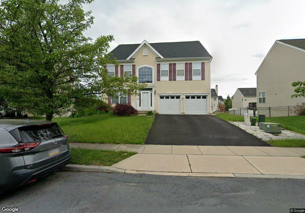
3459 Lurman Dr Macungie, PA 18062
Lower Macungie Township West NeighborhoodEstimated Value: $501,000 - $617,000
4
Beds
3
Baths
2,917
Sq Ft
$191/Sq Ft
Est. Value
About This Home
This home is located at 3459 Lurman Dr, Macungie, PA 18062 and is currently estimated at $557,507, approximately $191 per square foot. 3459 Lurman Dr is a home located in Lehigh County with nearby schools including Shoemaker Elementary School, Eyer Middle School, and Emmaus High School.
Ownership History
Date
Name
Owned For
Owner Type
Purchase Details
Closed on
Feb 26, 2007
Sold by
K Hovnanian @ Lower Macun
Bought by
Mitchell Kenneth F
Current Estimated Value
Home Financials for this Owner
Home Financials are based on the most recent Mortgage that was taken out on this home.
Original Mortgage
$311,000
Interest Rate
6.19%
Mortgage Type
New Conventional
Purchase Details
Closed on
Sep 25, 1978
Bought by
Jaindl Fred J
Create a Home Valuation Report for This Property
The Home Valuation Report is an in-depth analysis detailing your home's value as well as a comparison with similar homes in the area
Home Values in the Area
Average Home Value in this Area
Purchase History
| Date | Buyer | Sale Price | Title Company |
|---|---|---|---|
| Mitchell Kenneth F | $359,798 | -- | |
| Jaindl Fred J | $759,400 | -- |
Source: Public Records
Mortgage History
| Date | Status | Borrower | Loan Amount |
|---|---|---|---|
| Previous Owner | Mitchell Kenneth F | $311,000 |
Source: Public Records
Tax History Compared to Growth
Tax History
| Year | Tax Paid | Tax Assessment Tax Assessment Total Assessment is a certain percentage of the fair market value that is determined by local assessors to be the total taxable value of land and additions on the property. | Land | Improvement |
|---|---|---|---|---|
| 2025 | $6,817 | $267,000 | $27,100 | $239,900 |
| 2024 | $6,595 | $267,000 | $27,100 | $239,900 |
| 2023 | $6,463 | $267,000 | $27,100 | $239,900 |
| 2022 | $6,310 | $267,000 | $239,900 | $27,100 |
| 2021 | $6,176 | $267,000 | $27,100 | $239,900 |
| 2020 | $6,117 | $267,000 | $27,100 | $239,900 |
| 2019 | $6,013 | $267,000 | $27,100 | $239,900 |
| 2018 | $5,934 | $267,000 | $27,100 | $239,900 |
| 2017 | $5,830 | $267,000 | $27,100 | $239,900 |
| 2016 | -- | $267,000 | $27,100 | $239,900 |
| 2015 | -- | $267,000 | $27,100 | $239,900 |
| 2014 | -- | $267,000 | $27,100 | $239,900 |
Source: Public Records
Map
Nearby Homes
- 0 Clauss Hunt Knight Dr Unit 10 Units 763578
- 6903 Lincoln Dr
- 3814 Clay Dr
- 7230 Pioneer Dr
- 428 Thomas St
- 6672 Pioneer Dr
- 6709 Mountain Rd
- 6405 Robin Rd
- 0 Mountain Lot 1
- 167 Aspen Ln
- 2845 Donegal Dr
- 2840 Donegal Dr
- 121 S Main St Unit 123
- 2879 Sequoia Dr
- Lot 1 Mountain Rd
- 7318 Sauerkraut Ln Unit E
- 6528 Carmel Dr
- 204 Ridings Cir Unit F204
- 241 Flint Hill Rd
- 211 S Church St