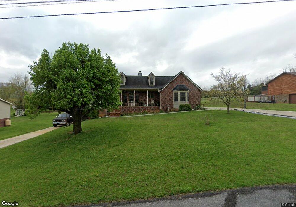
347 Carol Hill Dr Blountville, TN 37617
Estimated Value: $387,000 - $497,000
4
Beds
3
Baths
2,398
Sq Ft
$176/Sq Ft
Est. Value
About This Home
This home is located at 347 Carol Hill Dr, Blountville, TN 37617 and is currently estimated at $422,016, approximately $175 per square foot. 347 Carol Hill Dr is a home located in Sullivan County with nearby schools including Holston Elementary School, Sullivan Central Middle School, and Tri-Cities Christian Academy.
Ownership History
Date
Name
Owned For
Owner Type
Purchase Details
Closed on
Jan 13, 2006
Sold by
Danny Wilson
Bought by
William Schwartz
Current Estimated Value
Home Financials for this Owner
Home Financials are based on the most recent Mortgage that was taken out on this home.
Original Mortgage
$156,800
Outstanding Balance
$87,820
Interest Rate
6.21%
Estimated Equity
$334,196
Purchase Details
Closed on
Jul 22, 2004
Home Financials for this Owner
Home Financials are based on the most recent Mortgage that was taken out on this home.
Original Mortgage
$167,400
Interest Rate
6.22%
Purchase Details
Closed on
Jan 4, 1999
Create a Home Valuation Report for This Property
The Home Valuation Report is an in-depth analysis detailing your home's value as well as a comparison with similar homes in the area
Home Values in the Area
Average Home Value in this Area
Purchase History
| Date | Buyer | Sale Price | Title Company |
|---|---|---|---|
| William Schwartz | $196,000 | -- | |
| -- | $186,000 | -- | |
| -- | $143,500 | -- |
Source: Public Records
Mortgage History
| Date | Status | Borrower | Loan Amount |
|---|---|---|---|
| Open | -- | $156,800 | |
| Closed | -- | $19,600 | |
| Previous Owner | -- | $167,400 |
Source: Public Records
Tax History Compared to Growth
Tax History
| Year | Tax Paid | Tax Assessment Tax Assessment Total Assessment is a certain percentage of the fair market value that is determined by local assessors to be the total taxable value of land and additions on the property. | Land | Improvement |
|---|---|---|---|---|
| 2024 | $1,461 | $58,525 | $6,150 | $52,375 |
| 2023 | $1,408 | $58,525 | $6,150 | $52,375 |
| 2022 | $1,408 | $58,525 | $6,150 | $52,375 |
| 2021 | $1,408 | $58,525 | $6,150 | $52,375 |
| 2020 | $1,247 | $58,525 | $6,150 | $52,375 |
| 2019 | $1,247 | $48,525 | $6,150 | $42,375 |
| 2018 | $1,237 | $48,525 | $6,150 | $42,375 |
| 2017 | $1,237 | $48,525 | $6,150 | $42,375 |
| 2016 | $1,329 | $51,600 | $6,150 | $45,450 |
| 2014 | $1,190 | $51,621 | $0 | $0 |
Source: Public Records
Map
Nearby Homes
- 302 Carol Hill Dr
- 1888 Muddy Creek Rd
- 1876 Muddy Creek Rd
- Tbd Tennessee 75
- 0 Ethel Beard Rd
- 191 Neeley Place
- 309 Sammons Pvt Dr
- 544 Ethel Beard Rd
- 923 Muddy Creek Rd
- 550 Country View Private Dr
- 278 Pamela Ct
- 939 Muddy Creek Rd
- 1009 Muddy Creek Rd
- 999 Muddy Creek Rd
- 683 Ridge Dr
- 100 Polo Dr
- 744 Ridge Dr
- 4080 Highway 126
- 222 Polo Dr
- 209 Polo Dr
- 343 Carol Hill Dr
- 351 Carol Hill Dr
- 348 Carol Hill Dr
- 337 Carol Hill Dr
- 344 Carol Hill Dr
- 352 Carol Hill Dr
- 357 Carol Hill Dr
- 334 Carol Hill Dr
- 321 Carol Hill Dr
- 356 Carol Hill Dr
- 326 Carol Hill Dr
- 256 Pleasant Hill Rd
- 307 Carol Hill Dr
- 306 Carol Hill Dr
- 330 Pleasant Hill Rd
- 334 Muddy Creek Rd
- 301 Carol Hill Dr
- Tbd Pleasant Hill Rd
- 310 Pleasant Hill Rd
- 312 Pleasant Hill Church Rd