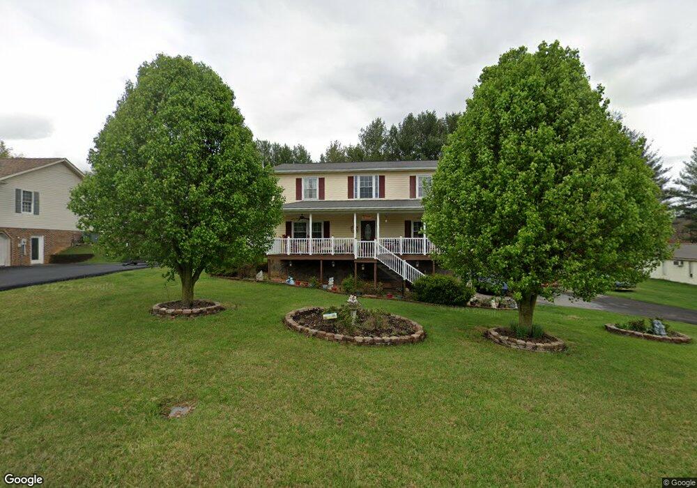
348 Carol Hill Dr Blountville, TN 37617
Estimated Value: $329,892 - $428,000
--
Bed
3
Baths
2,080
Sq Ft
$181/Sq Ft
Est. Value
About This Home
This home is located at 348 Carol Hill Dr, Blountville, TN 37617 and is currently estimated at $376,973, approximately $181 per square foot. 348 Carol Hill Dr is a home located in Sullivan County with nearby schools including Holston Elementary School, Sullivan Central Middle School, and Tri-Cities Christian Academy.
Ownership History
Date
Name
Owned For
Owner Type
Purchase Details
Closed on
Dec 5, 2003
Sold by
Stanley Jimmy R and Stanley Kathy
Bought by
Mitchell Traci L
Current Estimated Value
Home Financials for this Owner
Home Financials are based on the most recent Mortgage that was taken out on this home.
Original Mortgage
$84,000
Outstanding Balance
$39,169
Interest Rate
5.97%
Estimated Equity
$337,804
Create a Home Valuation Report for This Property
The Home Valuation Report is an in-depth analysis detailing your home's value as well as a comparison with similar homes in the area
Home Values in the Area
Average Home Value in this Area
Purchase History
| Date | Buyer | Sale Price | Title Company |
|---|---|---|---|
| Mitchell Traci L | $105,000 | -- |
Source: Public Records
Mortgage History
| Date | Status | Borrower | Loan Amount |
|---|---|---|---|
| Open | Mitchell Traci L | $84,000 |
Source: Public Records
Tax History Compared to Growth
Tax History
| Year | Tax Paid | Tax Assessment Tax Assessment Total Assessment is a certain percentage of the fair market value that is determined by local assessors to be the total taxable value of land and additions on the property. | Land | Improvement |
|---|---|---|---|---|
| 2024 | $1,265 | $50,675 | $6,100 | $44,575 |
| 2023 | $1,219 | $50,675 | $6,100 | $44,575 |
| 2022 | $1,219 | $50,675 | $6,100 | $44,575 |
| 2021 | $1,219 | $50,675 | $6,100 | $44,575 |
| 2020 | $1,081 | $50,675 | $6,100 | $44,575 |
| 2019 | $1,081 | $42,050 | $6,100 | $35,950 |
| 2018 | $1,072 | $42,050 | $6,100 | $35,950 |
| 2017 | $1,072 | $42,050 | $6,100 | $35,950 |
| 2016 | $1,077 | $41,825 | $6,100 | $35,725 |
| 2014 | -- | $41,829 | $0 | $0 |
Source: Public Records
Map
Nearby Homes
- 302 Carol Hill Dr
- 1888 Muddy Creek Rd
- 1876 Muddy Creek Rd
- Tbd Tennessee 75
- 0 Ethel Beard Rd
- 191 Neeley Place
- 309 Sammons Pvt Dr
- 544 Ethel Beard Rd
- 278 Pamela Ct
- 923 Muddy Creek Rd
- 550 Country View Private Dr
- 939 Muddy Creek Rd
- 1009 Muddy Creek Rd
- 100 Polo Dr
- 999 Muddy Creek Rd
- 4080 Highway 126
- 683 Ridge Dr
- 744 Ridge Dr
- 222 Polo Dr
- 209 Polo Dr
- 344 Carol Hill Dr
- 352 Carol Hill Dr
- 347 Carol Hill Dr
- 334 Carol Hill Dr
- 343 Carol Hill Dr
- 351 Carol Hill Dr
- 356 Carol Hill Dr
- 337 Carol Hill Dr
- 357 Carol Hill Dr
- 326 Carol Hill Dr
- 334 Muddy Creek Rd
- 321 Carol Hill Dr
- 306 Carol Hill Dr
- 307 Carol Hill Dr
- 256 Pleasant Hill Rd
- 301 Carol Hill Dr
- 330 Pleasant Hill Rd
- Tbd Pleasant Hill Rd
- 223 Pleasant Hill Rd
- 358 Muddy Creek Rd