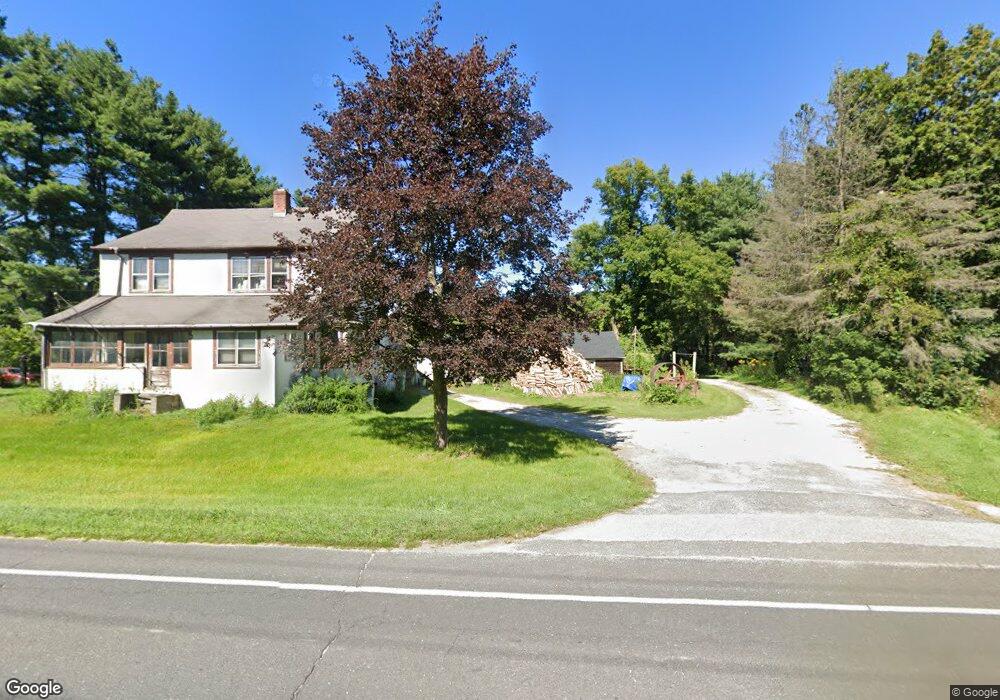
349 Norfolk Rd East Canaan, CT 06024
Estimated Value: $233,000 - $298,000
2
Beds
1
Bath
1,200
Sq Ft
$218/Sq Ft
Est. Value
About This Home
This home is located at 349 Norfolk Rd, East Canaan, CT 06024 and is currently estimated at $261,316, approximately $217 per square foot. 349 Norfolk Rd is a home with nearby schools including North Canaan Elementary School and Housatonic Valley Regional High School.
Ownership History
Date
Name
Owned For
Owner Type
Purchase Details
Closed on
Oct 14, 2009
Sold by
Debra A Spalding Ret and Spalding Debra A
Bought by
Miles Sonya
Current Estimated Value
Home Financials for this Owner
Home Financials are based on the most recent Mortgage that was taken out on this home.
Original Mortgage
$156,120
Outstanding Balance
$102,256
Interest Rate
5.14%
Estimated Equity
$159,060
Purchase Details
Closed on
Dec 19, 2002
Sold by
Williams Steven A and Williams Alison J
Bought by
Debra A Spalding Ret and Spalding William F
Create a Home Valuation Report for This Property
The Home Valuation Report is an in-depth analysis detailing your home's value as well as a comparison with similar homes in the area
Home Values in the Area
Average Home Value in this Area
Purchase History
| Date | Buyer | Sale Price | Title Company |
|---|---|---|---|
| Miles Sonya | $159,000 | -- | |
| Debra A Spalding Ret | $118,000 | -- |
Source: Public Records
Mortgage History
| Date | Status | Borrower | Loan Amount |
|---|---|---|---|
| Open | Debra A Spalding Ret | $156,120 |
Source: Public Records
Tax History Compared to Growth
Tax History
| Year | Tax Paid | Tax Assessment Tax Assessment Total Assessment is a certain percentage of the fair market value that is determined by local assessors to be the total taxable value of land and additions on the property. | Land | Improvement |
|---|---|---|---|---|
| 2025 | $2,940 | $118,790 | $30,940 | $87,850 |
| 2024 | $2,940 | $118,790 | $30,940 | $87,850 |
| 2023 | $3,029 | $118,790 | $30,940 | $87,850 |
| 2022 | $2,694 | $86,910 | $28,950 | $57,960 |
| 2021 | $2,520 | $86,910 | $28,950 | $57,960 |
| 2020 | $2,455 | $86,910 | $28,950 | $57,960 |
| 2019 | $2,455 | $86,910 | $28,950 | $57,960 |
| 2018 | $2,390 | $86,910 | $28,950 | $57,960 |
| 2017 | $2,437 | $88,620 | $32,080 | $56,540 |
| 2016 | $2,437 | $88,620 | $32,080 | $56,540 |
| 2015 | $2,437 | $88,620 | $32,080 | $56,540 |
| 2014 | $2,437 | $88,620 | $32,080 | $56,540 |
Source: Public Records
Map
Nearby Homes
- 10 College Hill Rd
- 46 Old Turnpike Rd N
- 123 Lower Rd
- 0 Old Turnpike Rd N
- 65 E Main St
- 16 River Place
- 18 Cross To Canaan Valley Rd
- 2170 Canaan Southfield Rd
- 00 N Elm St
- 0 Old Colony Rd
- 72 N Elm St Unit 2E
- 2010-2012 Clayton Mill River Rd
- 730 Clayton Rd
- 26 Granite Ave
- 33 Granite Ave
- 21 Shepard Rd
- 89 Under Mountain Rd
- 33 Shepard Rd
- 36 Furnace Brook Rd
- 246 Ashley Falls Rd
- 355 Norfolk Rd Unit US
- 363 Rte 44 E
- 357 Norfolk Rd
- 344 Norfolk Rd
- 4 Browns Ln
- 348 Norfolk Rd Unit US
- 359 Norfolk Rd
- 6 Browns Ln
- 343 Norfolk Rd
- 342 Norfolk Rd
- 8 Browns Ln
- 361 Norfolk Rd Unit US
- 340 Norfolk Rd
- 340 Norfolk Rd
- 340 Norfolk Rd
- 10 Browns Ln
- 338 Norfolk Rd
- 339 Norfolk Rd Unit US
- 57 Old Turnpike Rd S
- 319 U S 44