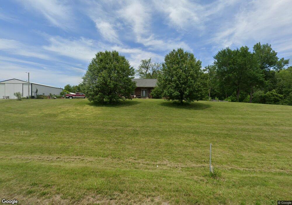
3617 Mine Haul Rd Millstadt, IL 62260
Estimated Value: $352,000 - $459,000
--
Bed
--
Bath
1,692
Sq Ft
$233/Sq Ft
Est. Value
About This Home
This home is located at 3617 Mine Haul Rd, Millstadt, IL 62260 and is currently estimated at $393,430, approximately $232 per square foot. 3617 Mine Haul Rd is a home located in St. Clair County with nearby schools including Millstadt Primary Center, Millstadt Consolidated School, and St James Catholic School.
Ownership History
Date
Name
Owned For
Owner Type
Purchase Details
Closed on
May 30, 2003
Sold by
Fletcher Max and Fletcher Lynn
Bought by
Neumeyer Ii Robert L and Neumeyer Vickie M
Current Estimated Value
Home Financials for this Owner
Home Financials are based on the most recent Mortgage that was taken out on this home.
Original Mortgage
$51,200
Outstanding Balance
$22,623
Interest Rate
5.9%
Mortgage Type
Purchase Money Mortgage
Estimated Equity
$370,807
Purchase Details
Closed on
Mar 9, 2001
Sold by
Mcginnis Martin and Mcginnis Carol
Bought by
Fletcher Max and Fletcher Lynn
Create a Home Valuation Report for This Property
The Home Valuation Report is an in-depth analysis detailing your home's value as well as a comparison with similar homes in the area
Home Values in the Area
Average Home Value in this Area
Purchase History
| Date | Buyer | Sale Price | Title Company |
|---|---|---|---|
| Neumeyer Ii Robert L | $64,000 | Benchmark Title Company | |
| Fletcher Max | $40,000 | Metro East Title Corp |
Source: Public Records
Mortgage History
| Date | Status | Borrower | Loan Amount |
|---|---|---|---|
| Open | Neumeyer Ii Robert L | $51,200 |
Source: Public Records
Tax History Compared to Growth
Tax History
| Year | Tax Paid | Tax Assessment Tax Assessment Total Assessment is a certain percentage of the fair market value that is determined by local assessors to be the total taxable value of land and additions on the property. | Land | Improvement |
|---|---|---|---|---|
| 2024 | $6,359 | $89,158 | $11,221 | $77,937 |
| 2023 | $5,984 | $79,998 | $10,068 | $69,930 |
| 2022 | $5,678 | $72,593 | $9,136 | $63,457 |
| 2021 | $5,487 | $67,397 | $8,482 | $58,915 |
| 2020 | $5,357 | $64,079 | $8,253 | $55,826 |
| 2019 | $5,293 | $64,079 | $8,253 | $55,826 |
| 2018 | $5,122 | $61,231 | $7,886 | $53,345 |
| 2017 | $4,836 | $57,025 | $7,344 | $49,681 |
| 2016 | $4,708 | $56,891 | $5,903 | $50,988 |
| 2014 | $4,367 | $57,217 | $5,937 | $51,280 |
| 2013 | $2,384 | $61,044 | $6,334 | $54,710 |
Source: Public Records
Map
Nearby Homes
- 3295 Veranda Ct
- 709 Admiral Wendt Pkwy
- 401 Pecan Ln
- 334 Spring Lake Rd
- 101 E Gooding St
- 109 E Gooding St
- 339 E Mill St
- 109 E Mill St
- 113 N Lafayette St
- 13 N Jackson St
- 130 Regency Place
- 103 W Madison St
- 29 Cedar St
- 87 Regency Place
- 519 W Madison St
- 7400 Concordia Rd
- 603 W White St
- 32 Adderly Ln
- 19 Adderly Ln
- 113 Adderly Ln
- 7145 State Route 163
- 7230 State Route 163
- 7133 State Route 163
- 7244 State Route 163
- 7264 State Route 163
- 7237 State Route 163
- 7356 State Route 163
- xxx Mine Haul Rd
- 3538 Schubert Ln
- 7319 My Lakeview Dr
- 3678 Lake Ln
- 3609 Lake Ln
- 7404 State Route 163
- 3668 Lake Ln
- 3669 Lake Ln
- 7077 State Route 163
- 7426 State Route 163
- 3454 White Pine Ct
- 6957 State Route 163
- 7008 State Route 163