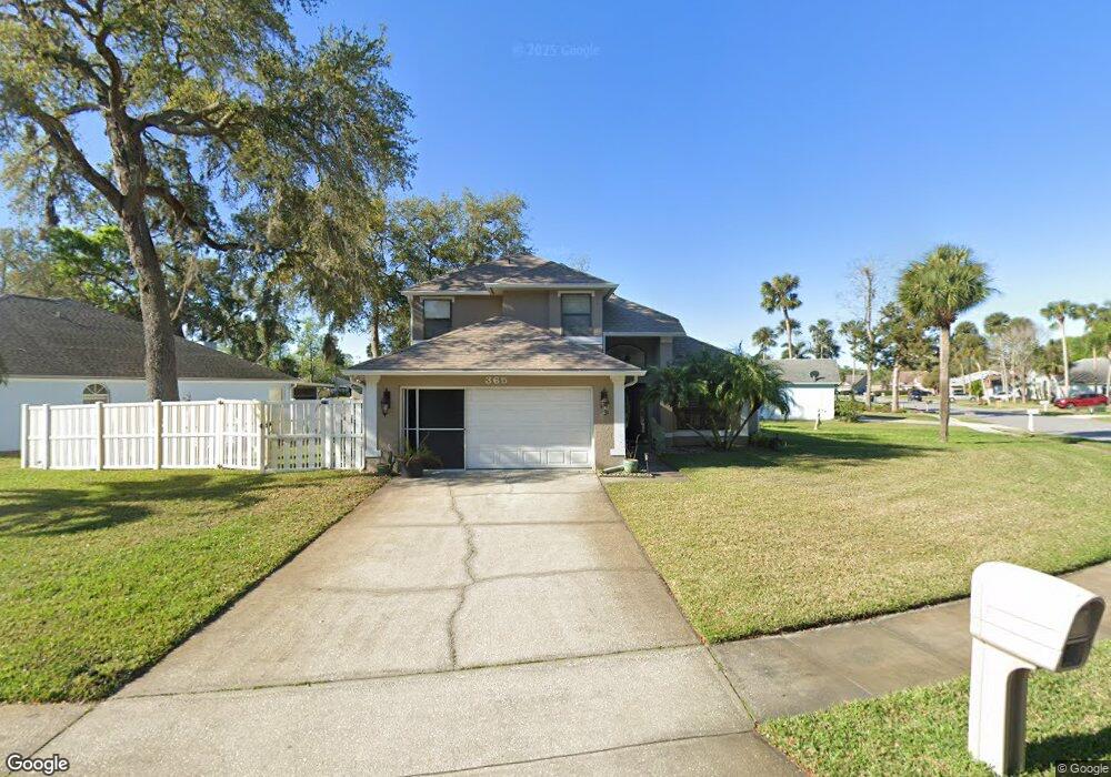
365 Aleatha Dr Daytona Beach, FL 32114
Central Daytona NeighborhoodEstimated Value: $318,182 - $369,000
3
Beds
2
Baths
2,176
Sq Ft
$160/Sq Ft
Est. Value
About This Home
This home is located at 365 Aleatha Dr, Daytona Beach, FL 32114 and is currently estimated at $348,546, approximately $160 per square foot. 365 Aleatha Dr is a home located in Volusia County with nearby schools including Turie T. Small Elementary School, Campbell Middle School, and Mainland High School.
Ownership History
Date
Name
Owned For
Owner Type
Purchase Details
Closed on
Feb 21, 2003
Sold by
Mason Thomas W and Mason Lois B
Bought by
Lewis Brown Carolyn M
Current Estimated Value
Home Financials for this Owner
Home Financials are based on the most recent Mortgage that was taken out on this home.
Original Mortgage
$104,900
Outstanding Balance
$44,926
Interest Rate
5.95%
Mortgage Type
Purchase Money Mortgage
Estimated Equity
$303,620
Purchase Details
Closed on
May 15, 1992
Bought by
Lewis-Brown Carolyn M
Create a Home Valuation Report for This Property
The Home Valuation Report is an in-depth analysis detailing your home's value as well as a comparison with similar homes in the area
Home Values in the Area
Average Home Value in this Area
Purchase History
| Date | Buyer | Sale Price | Title Company |
|---|---|---|---|
| Lewis Brown Carolyn M | $139,900 | -- | |
| Lewis-Brown Carolyn M | $103,400 | -- |
Source: Public Records
Mortgage History
| Date | Status | Borrower | Loan Amount |
|---|---|---|---|
| Open | Lewis Brown Carolyn M | $104,900 |
Source: Public Records
Tax History Compared to Growth
Tax History
| Year | Tax Paid | Tax Assessment Tax Assessment Total Assessment is a certain percentage of the fair market value that is determined by local assessors to be the total taxable value of land and additions on the property. | Land | Improvement |
|---|---|---|---|---|
| 2025 | $944 | $134,892 | -- | -- |
| 2024 | $944 | $131,091 | -- | -- |
| 2023 | $944 | $127,273 | $0 | $0 |
| 2022 | $894 | $123,566 | $0 | $0 |
| 2021 | $881 | $119,967 | $0 | $0 |
| 2020 | $1,470 | $118,311 | $0 | $0 |
| 2019 | $1,443 | $115,651 | $0 | $0 |
| 2018 | $1,450 | $113,495 | $0 | $0 |
| 2017 | $1,460 | $111,161 | $0 | $0 |
| 2016 | $1,482 | $108,875 | $0 | $0 |
| 2015 | $1,538 | $108,118 | $0 | $0 |
| 2014 | $1,534 | $107,260 | $0 | $0 |
Source: Public Records
Map
Nearby Homes
- 352 Aleatha Dr
- 215 Hollowbrook Cir
- 1167 Margina Ave
- 1182 Peachtree Rd
- 1208 Mardrake Rd
- 530 Shady Place
- 0 Shady Place
- 1212 Ruthbern Rd
- Lot 63 Benecia Ave
- 814 Benecia Ave
- 1125 Sunland Rd
- 1129 Sunland Rd
- 932 Lora St
- 1238 Suwanee Rd
- 800 Lora St
- 1312 Mardrake Rd
- 916 Kathy St
- 1317 Margina Ave
- 1305 Sunland Rd
- 835 Terrace Ave
- 375 Aleatha Dr
- 355 Aleatha Dr
- 360 Aleatha Dr
- 379 Aleatha Dr
- 364 Aleatha Dr
- 351 Aleatha Dr
- 372 Aleatha Dr
- 356 Aleatha Dr
- 376 Aleatha Dr
- 368 Aleatha Dr
- 380 Aleatha Dr
- 381 Aleatha Dr
- 347 Aleatha Dr
- 220 Hollowbrook Cir
- 1154 Margina Ave
- 384 Aleatha Dr
- 1158 Margina Ave
- 348 Aleatha Dr
- 216 Hollowbrook Cir
- 388 Aleatha Dr