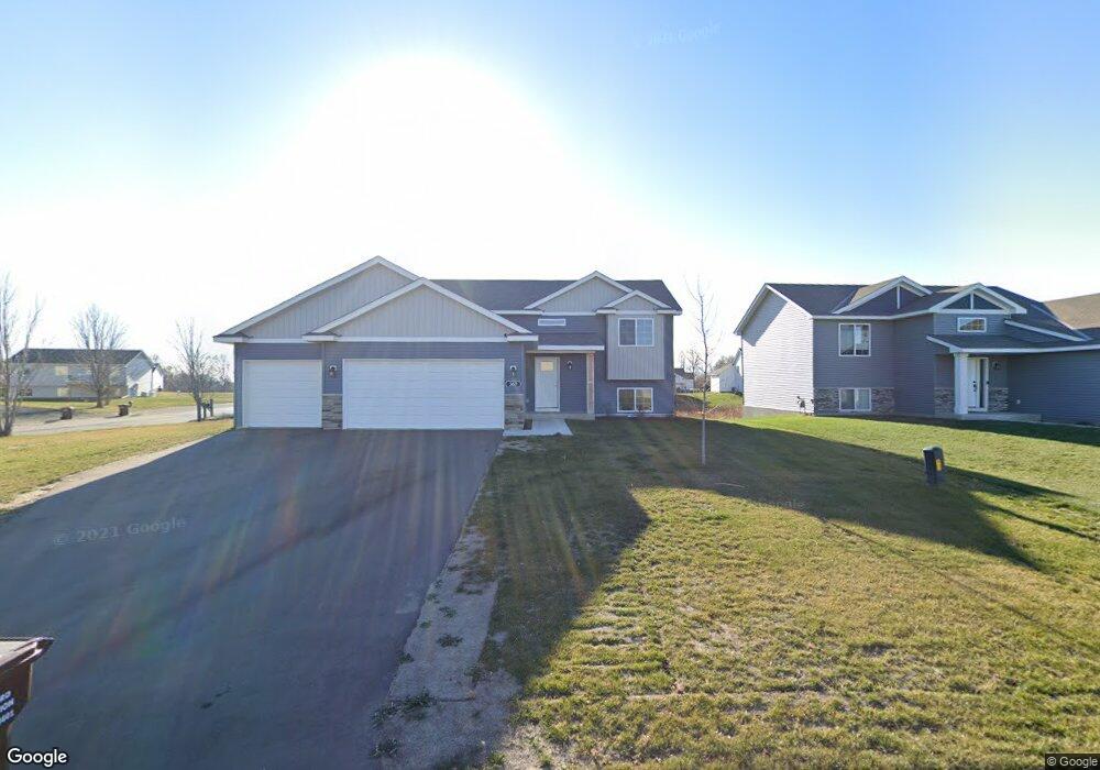
367 65 1/2 St SW Waverly, MN 55390
Estimated Value: $312,000 - $345,000
4
Beds
2
Baths
1,680
Sq Ft
$196/Sq Ft
Est. Value
About This Home
This home is located at 367 65 1/2 St SW, Waverly, MN 55390 and is currently estimated at $328,796, approximately $195 per square foot. 367 65 1/2 St SW is a home located in Wright County with nearby schools including Humphrey Elementary School, Winsted Elementary School, and Howard Lake-Waverly-Winsted Middle School.
Ownership History
Date
Name
Owned For
Owner Type
Purchase Details
Closed on
Jan 13, 2020
Sold by
Jp Brooks Inc
Bought by
Rosdahl Kaitlin and Froid Devyn
Current Estimated Value
Home Financials for this Owner
Home Financials are based on the most recent Mortgage that was taken out on this home.
Original Mortgage
$259,813
Interest Rate
2.71%
Mortgage Type
FHA
Purchase Details
Closed on
Aug 31, 2011
Sold by
Lcf Funding I Llc
Bought by
Gb Land Llc
Create a Home Valuation Report for This Property
The Home Valuation Report is an in-depth analysis detailing your home's value as well as a comparison with similar homes in the area
Home Values in the Area
Average Home Value in this Area
Purchase History
| Date | Buyer | Sale Price | Title Company |
|---|---|---|---|
| Rosdahl Kaitlin | $264,606 | Results Title Inc | |
| Gb Land Llc | $300,000 | -- | |
| Rosdahl Kaitlin Kaitlin | $264,600 | -- |
Source: Public Records
Mortgage History
| Date | Status | Borrower | Loan Amount |
|---|---|---|---|
| Previous Owner | Rosdahl Kaitlin | $259,813 | |
| Closed | Rosdahl Kaitlin Kaitlin | $259,813 |
Source: Public Records
Tax History Compared to Growth
Tax History
| Year | Tax Paid | Tax Assessment Tax Assessment Total Assessment is a certain percentage of the fair market value that is determined by local assessors to be the total taxable value of land and additions on the property. | Land | Improvement |
|---|---|---|---|---|
| 2025 | $3,532 | $293,600 | $70,000 | $223,600 |
| 2024 | $3,514 | $293,500 | $78,000 | $215,500 |
| 2023 | $3,262 | $298,000 | $77,000 | $221,000 |
| 2022 | $3,320 | $272,400 | $65,000 | $207,400 |
| 2021 | $620 | $232,200 | $43,000 | $189,200 |
| 2020 | $638 | $25,000 | $25,000 | $0 |
| 2019 | $502 | $25,000 | $0 | $0 |
| 2018 | $512 | $17,500 | $0 | $0 |
| 2017 | $474 | $9,900 | $0 | $0 |
| 2016 | $486 | $0 | $0 | $0 |
| 2015 | $494 | $0 | $0 | $0 |
| 2014 | -- | $0 | $0 | $0 |
Source: Public Records
Map
Nearby Homes
- 6502 Dale Cir SW
- 6507 Dale Cir SW
- 419 66th St SW
- 2105 Birch Ln
- 2002 Apple Ln
- 2113 Birch Ln
- 2008 Apple Ln
- 2010 Apple Ln
- 331 Bavaria Ln
- 1766 US Highway 12 SW
- 1012 Brandenburg Ln
- 815 Cologne Ln
- 1004 Brandenburg Cir
- 1002 Brandenburg Ln
- 1002 Brandenburg Cir
- 1009 Brandenburg Ln
- 1004 Brandenburg Ln
- The Oak Ridge Plan at Carrigan Meadows
- The Waterford Plan at Carrigan Meadows
- The Madison Villa Plan at Carrigan Meadows
- XXXX 65 1 2 Ave SW
- 367 65 1/2 St SW
- 365 65 1 2 Ave SW
- 363 1 1/2 St S
- 363 65 1 2 Ave SW
- L5 B9 6509 Dempsey Ave SW
- 6509 Dempsey Ave SW
- 6550 Dempsey Ave SW
- 376 66th St SW
- Unknown Unknonwn
- 6512 Dempsey Ave SW
- 374 66th St SW
- 6552 Dempsey Ave SW
- 6508 Dale Cir SW
- 400 66th St SW
- 361 65 1 2 Ave SW
- 361 65 1 2 Street South W
- 6508 Dempsey Ave SW
- XXXX SW 66th St
- 370 66th St SW