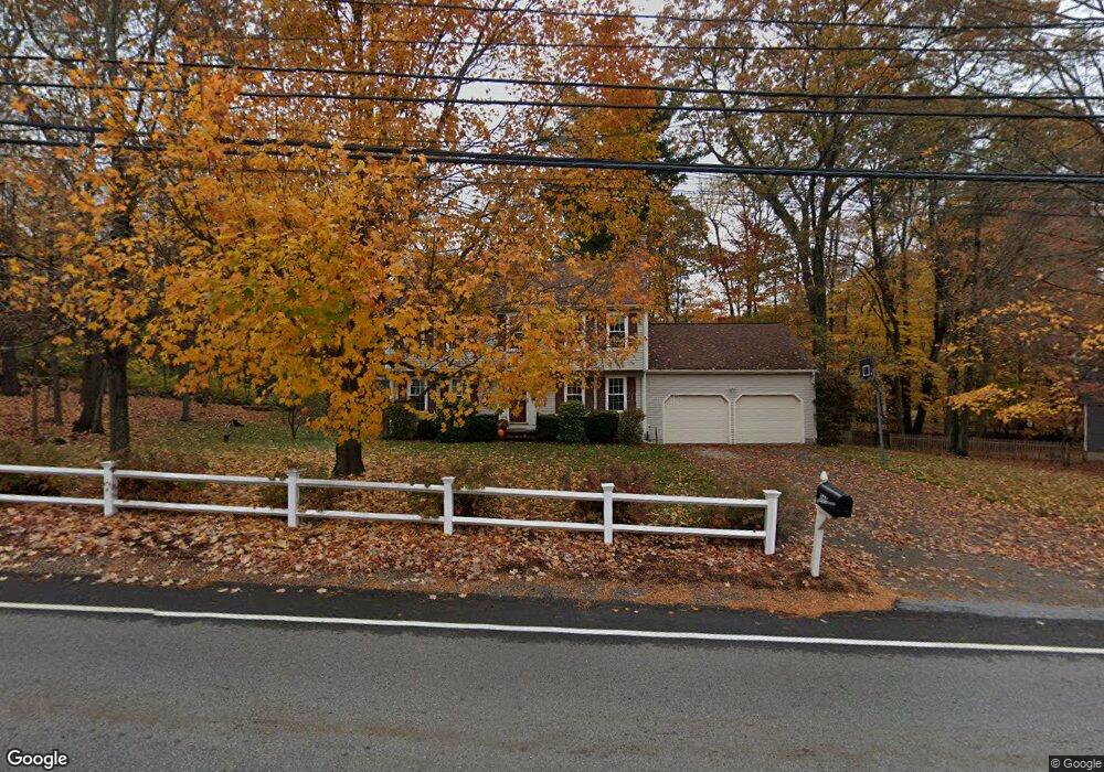
369 Oak St Franklin, MA 02038
Estimated Value: $744,706 - $839,000
4
Beds
3
Baths
1,944
Sq Ft
$409/Sq Ft
Est. Value
About This Home
This home is located at 369 Oak St, Franklin, MA 02038 and is currently estimated at $795,427, approximately $409 per square foot. 369 Oak St is a home located in Norfolk County with nearby schools including Oak Street Elementary School, Horace Mann Middle School, and Franklin High School.
Ownership History
Date
Name
Owned For
Owner Type
Purchase Details
Closed on
Sep 20, 2001
Sold by
Loomis Craig L and Loomis Jamie L
Bought by
Zuvekas Samuel R and Rodero Margaret L
Current Estimated Value
Purchase Details
Closed on
Jan 19, 1999
Sold by
Dadamo Jodene K
Bought by
Loomis Craig L and Loomis Jamie L
Purchase Details
Closed on
Oct 11, 1995
Sold by
Mitchell Jeffrey P and Mitchell Carol D
Bought by
Dadamo Jodene
Purchase Details
Closed on
Mar 16, 1992
Sold by
Dellorco Paul
Bought by
Mitchell Jeffrey P and Mitchell Carol D
Create a Home Valuation Report for This Property
The Home Valuation Report is an in-depth analysis detailing your home's value as well as a comparison with similar homes in the area
Home Values in the Area
Average Home Value in this Area
Purchase History
| Date | Buyer | Sale Price | Title Company |
|---|---|---|---|
| Zuvekas Samuel R | $330,000 | -- | |
| Loomis Craig L | $222,000 | -- | |
| Dadamo Jodene | $185,000 | -- | |
| Mitchell Jeffrey P | $168,000 | -- |
Source: Public Records
Mortgage History
| Date | Status | Borrower | Loan Amount |
|---|---|---|---|
| Open | Mitchell Jeffrey P | $87,000 | |
| Open | Mitchell Jeffrey P | $261,000 | |
| Closed | Mitchell Jeffrey P | $25,000 |
Source: Public Records
Tax History Compared to Growth
Tax History
| Year | Tax Paid | Tax Assessment Tax Assessment Total Assessment is a certain percentage of the fair market value that is determined by local assessors to be the total taxable value of land and additions on the property. | Land | Improvement |
|---|---|---|---|---|
| 2025 | $7,744 | $666,400 | $238,200 | $428,200 |
| 2024 | $7,344 | $622,900 | $238,200 | $384,700 |
| 2023 | $7,479 | $594,500 | $260,000 | $334,500 |
| 2022 | $6,948 | $494,500 | $198,500 | $296,000 |
| 2021 | $6,531 | $445,800 | $206,700 | $239,100 |
| 2020 | $6,329 | $436,200 | $208,500 | $227,700 |
| 2019 | $6,016 | $410,400 | $182,900 | $227,500 |
| 2018 | $5,735 | $391,500 | $186,600 | $204,900 |
| 2017 | $5,654 | $387,800 | $182,900 | $204,900 |
| 2016 | $5,681 | $391,800 | $189,800 | $202,000 |
| 2015 | $5,543 | $373,500 | $171,500 | $202,000 |
| 2014 | $5,325 | $368,500 | $166,500 | $202,000 |
Source: Public Records
Map
Nearby Homes
- 208 Irondequoit Rd
- 159 Highwood Dr
- 66 Highwood Dr
- 336 Maple St
- 31 Highwood Dr
- 2211 Franklin Crossing Rd Unit 2211
- 1805 Franklin Crossing Rd
- 2 Kayla Dr
- 605 Franklin Crossing Rd
- 57 Raymond St Unit 2
- 41 Kimberlee Ave
- 2 Noanet Brook Ln
- 6 Buena Vista Dr
- 14 Pleasant St Unit A
- 204 Lincoln St
- 17 Longhill Rd
- 48 Pinehurst St
- 0 Upper Union St Unit 73230551
- 120 Union St Unit 1
- 60 Southgate Rd