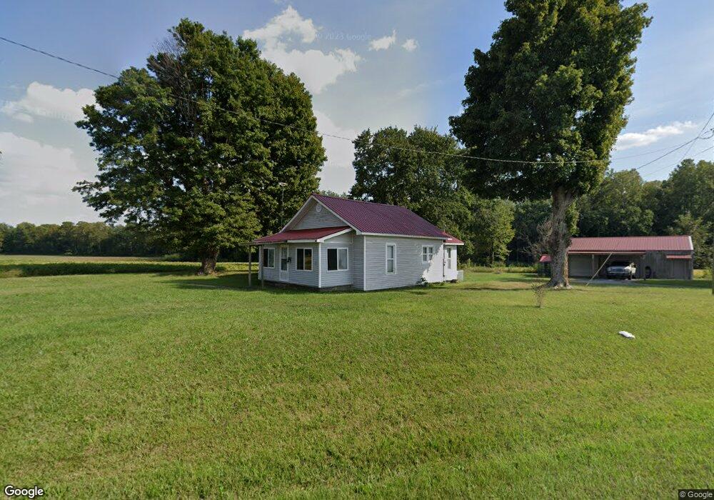
3713 W Highway 22 Union City, TN 38261
Estimated Value: $106,000 - $216,000
4
Beds
1
Bath
1,443
Sq Ft
$97/Sq Ft
Est. Value
About This Home
This home is located at 3713 W Highway 22, Union City, TN 38261 and is currently estimated at $139,795, approximately $96 per square foot. 3713 W Highway 22 is a home located in Obion County.
Ownership History
Date
Name
Owned For
Owner Type
Purchase Details
Closed on
Jun 8, 2018
Sold by
Flowers Richard
Bought by
Bruce Johnny Wayne
Current Estimated Value
Purchase Details
Closed on
Sep 12, 2008
Sold by
Us Bank Na
Bought by
Richard Flowers
Purchase Details
Closed on
Jan 30, 2008
Bought by
Us Bank
Purchase Details
Closed on
Oct 10, 2003
Bought by
Robbins Thomas E and Robbins Felisha D
Purchase Details
Closed on
Nov 22, 2000
Sold by
Union Planters Bank
Bought by
Bebhanub Wukjubs
Purchase Details
Closed on
May 8, 2000
Sold by
Aaron Litchford
Bought by
Union Planters Bank
Purchase Details
Closed on
Aug 13, 1993
Bought by
Litchford Aaron Eutx Michele
Purchase Details
Closed on
Jan 1, 1983
Bought by
Haynes Lanny and Haynes Deborah
Purchase Details
Closed on
Jan 2, 1982
Create a Home Valuation Report for This Property
The Home Valuation Report is an in-depth analysis detailing your home's value as well as a comparison with similar homes in the area
Home Values in the Area
Average Home Value in this Area
Purchase History
| Date | Buyer | Sale Price | Title Company |
|---|---|---|---|
| Bruce Johnny Wayne | $55,000 | -- | |
| Richard Flowers | $16,000 | -- | |
| Us Bank | $29,800 | -- | |
| Robbins Thomas E | $54,000 | -- | |
| Bebhanub Wukjubs | $32,000 | -- | |
| Union Planters Bank | $20,500 | -- | |
| Litchford Aaron Eutx Michele | $32,000 | -- | |
| Haynes Lanny | $8,500 | -- | |
| -- | $13,800 | -- |
Source: Public Records
Tax History Compared to Growth
Tax History
| Year | Tax Paid | Tax Assessment Tax Assessment Total Assessment is a certain percentage of the fair market value that is determined by local assessors to be the total taxable value of land and additions on the property. | Land | Improvement |
|---|---|---|---|---|
| 2025 | $315 | $22,800 | $0 | $0 |
| 2024 | $315 | $22,800 | $1,050 | $21,750 |
| 2023 | $315 | $22,800 | $1,050 | $21,750 |
| 2022 | $285 | $14,975 | $950 | $14,025 |
| 2021 | $285 | $14,975 | $950 | $14,025 |
| 2020 | $272 | $14,975 | $950 | $14,025 |
| 2019 | $272 | $14,325 | $950 | $13,375 |
| 2018 | $273 | $14,325 | $950 | $13,375 |
| 2017 | $311 | $15,500 | $950 | $14,550 |
| 2016 | $311 | $15,500 | $950 | $14,550 |
| 2015 | $311 | $15,500 | $950 | $14,550 |
| 2014 | $311 | $15,500 | $950 | $14,550 |
Source: Public Records
Map
Nearby Homes
- 3454 Treece Rd
- 0 Bogus Hollow Rd
- 0 Walnut Logging Rd
- 5030 Rogers Marshall Rd
- 2727 Marvin Vaught Rd
- 4744 N Clayton Antioch Rd
- 4310 Old Samburg Rd
- 3216 W Shawtown Rd
- 3232 W Shawtown Rd
- 4211 Old Samburg Rd
- 000 Old Samburg Rd
- 1559 Ella Groom Rd
- 1127 W Shawtown Rd
- 4830 Kendall Rd
- 3272 St Rt 925
- 0 Denson Rd
- 354 E Lakeview Dr
- 257 2nd Ave
- 0 Lakeview Dr Unit RRA45037
- 848 Bethel Church Rd