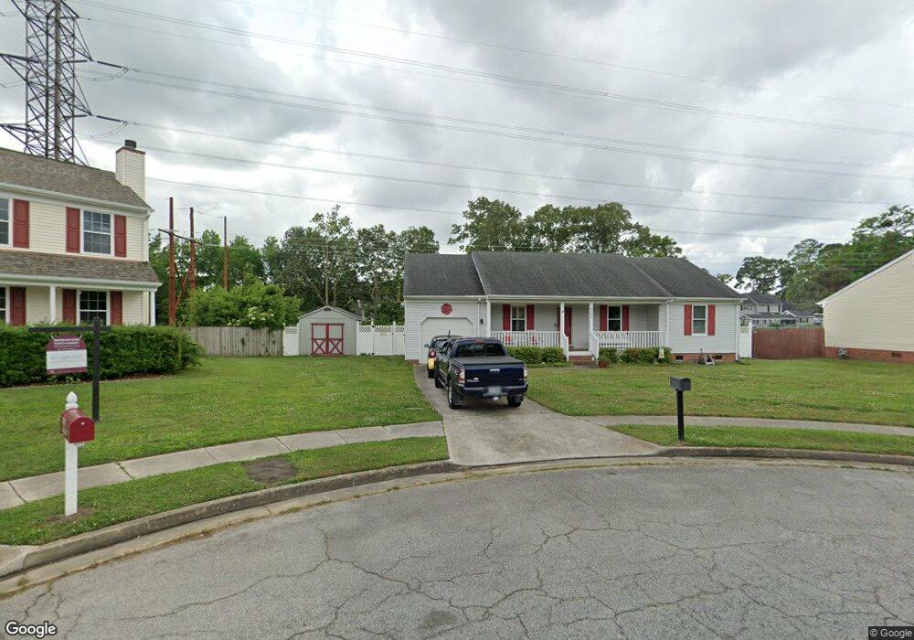
3793 Lilac Dr Portsmouth, VA 23703
Churchland NeighborhoodEstimated Value: $338,221 - $365,000
3
Beds
2
Baths
1,448
Sq Ft
$241/Sq Ft
Est. Value
About This Home
This home is located at 3793 Lilac Dr, Portsmouth, VA 23703 and is currently estimated at $348,555, approximately $240 per square foot. 3793 Lilac Dr is a home located in Portsmouth City with nearby schools including Churchland Elementary School, Churchland Academy Elementary School, and Churchland Middle School.
Ownership History
Date
Name
Owned For
Owner Type
Purchase Details
Closed on
Jun 30, 2014
Sold by
Bowling Robert W
Bought by
Bowling Robert W and Arrington Jeanne C
Current Estimated Value
Purchase Details
Closed on
May 27, 2010
Sold by
Williamson Todd H
Bought by
Bowling Robert W
Home Financials for this Owner
Home Financials are based on the most recent Mortgage that was taken out on this home.
Original Mortgage
$184,515
Interest Rate
4.87%
Mortgage Type
FHA
Purchase Details
Closed on
Mar 26, 1999
Sold by
Hester Randall L
Bought by
Williamson Todd H
Home Financials for this Owner
Home Financials are based on the most recent Mortgage that was taken out on this home.
Original Mortgage
$105,470
Interest Rate
6.78%
Create a Home Valuation Report for This Property
The Home Valuation Report is an in-depth analysis detailing your home's value as well as a comparison with similar homes in the area
Home Values in the Area
Average Home Value in this Area
Purchase History
| Date | Buyer | Sale Price | Title Company |
|---|---|---|---|
| Bowling Robert W | -- | -- | |
| Bowling Robert W | $187,000 | -- | |
| Williamson Todd H | $106,000 | -- |
Source: Public Records
Mortgage History
| Date | Status | Borrower | Loan Amount |
|---|---|---|---|
| Previous Owner | Bowling Robert W | $184,515 | |
| Previous Owner | Williamson Todd H | $105,470 |
Source: Public Records
Tax History Compared to Growth
Tax History
| Year | Tax Paid | Tax Assessment Tax Assessment Total Assessment is a certain percentage of the fair market value that is determined by local assessors to be the total taxable value of land and additions on the property. | Land | Improvement |
|---|---|---|---|---|
| 2025 | $3,500 | $272,050 | $82,800 | $189,250 |
| 2024 | $3,500 | $270,640 | $82,800 | $187,840 |
| 2023 | $3,029 | $242,350 | $82,800 | $159,550 |
| 2022 | $2,898 | $222,890 | $69,000 | $153,890 |
| 2021 | $2,637 | $202,870 | $56,050 | $146,820 |
| 2020 | $2,603 | $200,200 | $53,380 | $146,820 |
| 2019 | $2,511 | $193,130 | $53,380 | $139,750 |
| 2018 | $2,511 | $193,130 | $53,380 | $139,750 |
| 2017 | $2,419 | $186,060 | $53,380 | $132,680 |
| 2016 | $2,364 | $181,820 | $53,380 | $128,440 |
| 2015 | $2,364 | $181,820 | $53,380 | $128,440 |
| 2014 | $2,309 | $181,820 | $53,380 | $128,440 |
Source: Public Records
Map
Nearby Homes
- 5300 Larkspur Rd
- 10AC Cedar Ln
- 3604 Lilac Dr
- 4008 Oakhurst Rd
- 4959 Briarwood Ln
- 3315 Camellia Dr
- 5516 Bingham Dr
- 4955 Briarwood Ln
- 5806 Fawkes St
- 3509 Spence Rd
- 3433 Willow Breeze Dr
- 3728 Cardinal Ln
- 4028 Swannanoa Dr
- 3432 Carter Rd
- 3616 Bowden St
- 5911 Dunkirk St
- 4808 Thornwood St
- 5807 Dunkin St
- 6002 Campbell St
- 6015 Arthur Ave