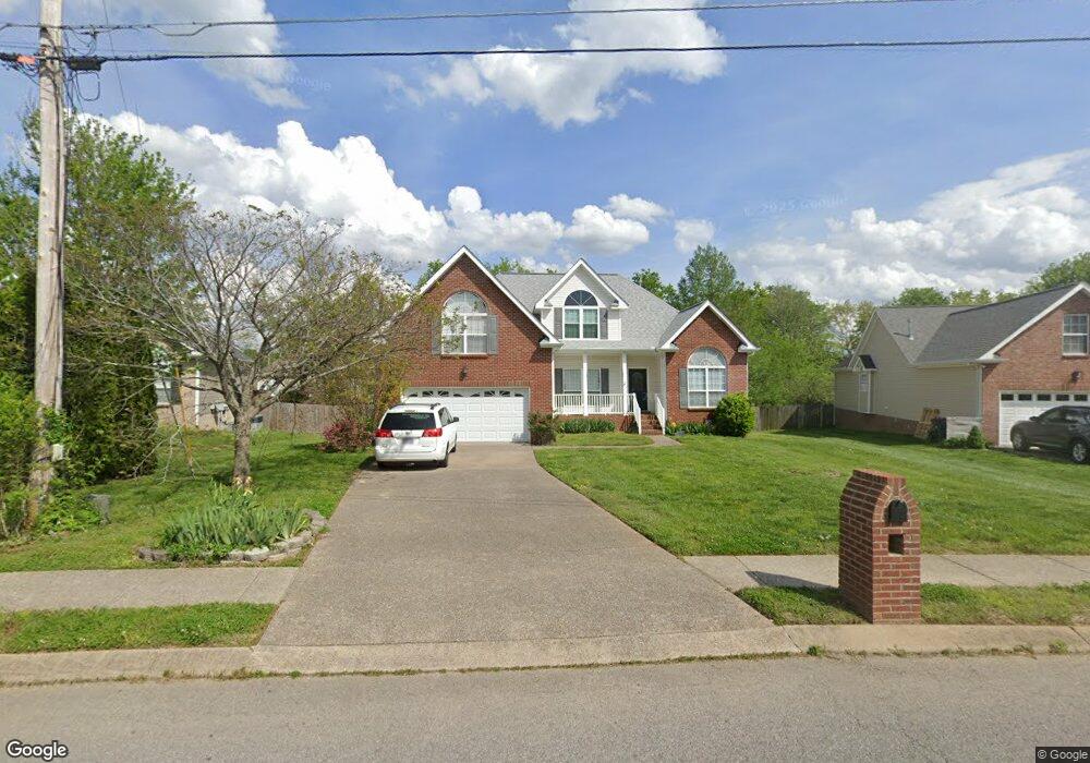
393 Remington Ave Gallatin, TN 37066
Estimated Value: $429,225 - $539,000
--
Bed
3
Baths
2,374
Sq Ft
$206/Sq Ft
Est. Value
About This Home
This home is located at 393 Remington Ave, Gallatin, TN 37066 and is currently estimated at $490,056, approximately $206 per square foot. 393 Remington Ave is a home located in Sumner County with nearby schools including Howard Elementary School, Rucker Stewart Middle School, and Station Camp High School.
Ownership History
Date
Name
Owned For
Owner Type
Purchase Details
Closed on
Oct 30, 2023
Sold by
Rose Cottage Trust
Bought by
Keitzman Patricia A and Keitzman Kerry R
Current Estimated Value
Purchase Details
Closed on
Sep 29, 2022
Sold by
Keitzman Patricia A
Bought by
Rose Cottage Trust
Purchase Details
Closed on
Aug 29, 2003
Sold by
Goodall Inc Builders
Bought by
Keitzman Brad C and Keitzman Patricia A
Purchase Details
Closed on
May 8, 2003
Sold by
Tyree Woods Co
Bought by
Goodall Inc Builders
Create a Home Valuation Report for This Property
The Home Valuation Report is an in-depth analysis detailing your home's value as well as a comparison with similar homes in the area
Home Values in the Area
Average Home Value in this Area
Purchase History
| Date | Buyer | Sale Price | Title Company |
|---|---|---|---|
| Keitzman Patricia A | $187,310 | None Listed On Document | |
| Rose Cottage Trust | -- | -- | |
| Keitzman Brad C | $187,310 | Realty Title & Escrow Co Inc | |
| Goodall Inc Builders | $20,000 | -- |
Source: Public Records
Tax History Compared to Growth
Tax History
| Year | Tax Paid | Tax Assessment Tax Assessment Total Assessment is a certain percentage of the fair market value that is determined by local assessors to be the total taxable value of land and additions on the property. | Land | Improvement |
|---|---|---|---|---|
| 2024 | $1,698 | $119,500 | $21,250 | $98,250 |
| 2023 | $2,179 | $71,425 | $16,250 | $55,175 |
| 2022 | $2,187 | $71,425 | $16,250 | $55,175 |
| 2021 | $2,187 | $71,425 | $16,250 | $55,175 |
| 2020 | $2,187 | $71,425 | $16,250 | $55,175 |
| 2019 | $2,187 | $0 | $0 | $0 |
| 2018 | $1,780 | $0 | $0 | $0 |
| 2017 | $1,780 | $0 | $0 | $0 |
| 2016 | $1,275 | $0 | $0 | $0 |
| 2015 | $1,780 | $0 | $0 | $0 |
| 2014 | $1,627 | $0 | $0 | $0 |
Source: Public Records
Map
Nearby Homes
- 1239 Wentworth Dr
- 420 Dorchester Place
- 1273 Wentworth Dr
- 376 Huntington Dr
- 415 Buckingham Blvd
- 294 Buckingham Blvd
- 540 Bradford Dr
- 1245 Amherst Ct
- 300 Remington Ave
- 608 Bradford Dr
- 1328 Wentworth Dr
- 305 Remington Ave
- 156 Hackney Ln
- 1036 Middleton Ln
- 130 Saxony Way
- 1017 Laurelwood Dr
- 139 Buckingham Blvd
- 1017 Wickshire Dr
- 806 Warrington Ct
- 1182 Long Hollow Pike Unit G3
- 397 Remington Ave
- 389 Remington Ave
- 424 Lenox Place
- 401 Remington Ave
- 420 Lenox Place
- 428 Lenox Place
- 1236 Wentworth Dr
- 416 Lenox Place
- 1232 Wentworth Dr
- 1244 Wentworth Dr
- 405 Remington Ave
- 398 Remington Ave
- 1228 Wentworth Dr
- 432 Lenox Place
- 1248 Wentworth Dr
- 409 Remington Ave
- 412 Lenox Place
- 1222 Wentworth Dr
- 1252 Wentworth Dr
- 1252 Wentworth Dr Unit 1252