NOT LISTED FOR SALE

397 Palisade Trail Driggs, ID 83422

Estimated Value: $105,000 - $794,000

0.27 Acre
$1,171,478 Price per Acre
11,761 Sq Ft Lot

Last Sold September 22, 2023

Current estimated payment $1,706/month

34 Days on Market

About This Lot

As of September 2023

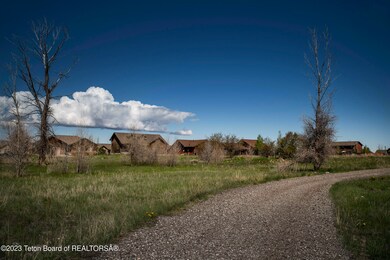
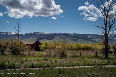
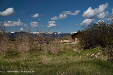
This rolling Driggs City corner lot adorn with trees and boarding open space is ready for home plans. A private nature trail meanders to lush city parks and provides walkability to the sidewalks and amenities of Downtown Driggs. City utilities, electricity, and fiber optic make for simple planning. Excellent location enables close proximity to town yet access to all the outdoor recreation Teton Valley has to offer.

Last Agent to Sell the Property

Tayson Rockefeller

Teton Valley Realty License #SP39380 Listed on: 07/20/2023

Last Buyer's Agent

Joy Hart

Teton Valley Realty License #SP56698

Property Details

Property Type

  • Land

Est. Annual Taxes

  • $501

Lot Details

  • 0.27 Acre Lot
  • Year Round Access
  • Level Lot

Property Views

  • Mountain Views

Utilities

  • Electricity To Lot Line
  • Fiber Optics Available

Community Details

  • Property has a Home Owners Association
  • Shoshoni Plains Subdivision

Listing and Financial Details

  • Assessor Parcel Number RPA00442000090

Property Details

Property Type

Land

Est. Annual Taxes

$501

Lot Details

0

Listing Details

  • Prop. Type: Building Site
  • Horses: No
  • Lot Size Acres: 0.27
  • Subdivision Name: Shoshoni Plains
  • Property Info:Horses Allowed: No
  • Property Features:Flat: Yes
  • Property Features:Year Round Access: Yes
  • View:Mountain View: Yes
  • Property Features:Electric to Property: Yes
  • Water:Public: Yes
  • Sewer:Public2: Yes
  • Property Features:Fiber Optic to Property: Yes
  • Special Features: None
  • Property Sub Type: LotsLands

Exterior Features

  • Lot Features: Year Round Access, ST Rental Allowed, Level
  • View: Grand Teton View, Mountain(s)

Utilities

  • Electricity On Property: Yes
  • Sewer: Public Sewer
  • Water Source: Public

Condo/Co-op/Association

  • Association Fee: 50.0
  • Association: Yes

Lot Info

  • Lot Size Sq Ft: 11761.2
  • Parcel #: RPA00442000090
  • Zoning Description: Single Family
  • ResoLotSizeUnits: Acres

Tax Info

  • Tax Annual Amount: 500.8
  • Tax Year: 2022

Ownership History

Date Name Owned For Owner Type

Purchase Details

Closed on
Apr 13, 2022
Sold by
Arne Carter
Bought by
Aa Real Property Investments Llc
Current Estimated Value
$316,299

Purchase Details

Closed on
Apr 23, 2007
Sold by
Jackson James K
Bought by
Achim John and Achim Karen

Home Financials for this Owner

Home Financials are based on the most recent Mortgage that was taken out on this home.
Original Mortgage
$53,600
Interest Rate
6.29%
Mortgage Type
New Conventional

Purchase Details

Closed on
Mar 22, 2007
Sold by
Western Teton Development Llc
Bought by
Brant Thomas and Brant Meryanda

Home Financials for this Owner

Home Financials are based on the most recent Mortgage that was taken out on this home.
Original Mortgage
$53,600
Interest Rate
6.29%
Mortgage Type
New Conventional
Source: Public Records

Range of Values:

--
Value Increase
--
Percent Increase
--
Adjusted for Inflation
Collateral Analytics

Collateral Analytics Collateral Analytics AVMs (Automated Valuation Model) employ a number of statistical approaches combined with neighborhood-specific comparable selection guarantees the most up-to-date and precise valuations.

Not Available

Collateral Analytics does not have data for the current month. Please view the chart for historical values.

ICE

ICE Mortgage Technology ICE Mortgage Technology’s AVM (Automated Valuation Model) is a state-of-the-art online residential property valuation tool that provides a quick and accurate estimate of the value of almost any home in the U.S.

Not Available

ICE Mortgage Technology does not have data for the current month. Please view the chart for historical values.

First American

First American First American Data & Analytics’ next-generation AVM combines unrivaled data assets with a blended ensemble of valuation models to produce highly accurate, reliable valuations you can trust.

Not Available

First American does not have data for the current month. Please view the chart for historical values.

Quantarium

Quantarium Quantarium’s valuation service, repeatedly proven the industry’s most accurate and comprehensive, is supercharged with a self-learning and auto-tuning AI engine that continually becomes smarter and more accurate as it processes daily inputs from the industry’s leading RE data lake.

Not Available

Quantarium does not have data for the current month. Please view the chart for historical values.

Average Value
Not Available
List Price
Sold Price
Create a Home Valuation Report for This Property
The Home Valuation Report is an in-depth analysis detailing your home's value as well as a comparison with similar homes in the area

Home Values in the Area

Source: Public Records

Average Home Value in this Area


Source: Public Records

Purchase History

Date Buyer Sale Price Title Company
Aa Real Property Investments Llc -- Brindley Sullivan Pllc
Achim John -- --
Brant Thomas -- --
Source: Public Records

Mortgage History

Date Status Borrower Loan Amount
Previous Owner Brant Thomas $53,600
Source: Public Records

Property History

Date Event Price List to Sale Price per Sq Ft Prior Sale
09/22/2023 09/22/23 Sold -- -- --
08/24/2023 08/24/23 Pending -- -- --
07/20/2023 07/20/23 For Sale $135,000 +28.6% --
05/21/2021 05/21/21 Sold -- -- -- View Prior Sale
05/05/2021 05/05/21 Pending -- -- --
04/28/2021 04/28/21 For Sale $105,000 -- --
Source: Teton Board of REALTORS®

Tax History Compared to Growth

Source: Public Records

Tax History

Year Tax Paid Tax Assessment Tax Assessment Total Assessment is a certain percentage of the fair market value that is determined by local assessors to be the total taxable value of land and additions on the property. Land Improvement
2025 $565 $140,000 $140,000 $0
2024 $490 $120,000 $120,000 $0
2023 $490 $120,000 $120,000 $0
2022 $501 $100,000 $100,000 $0
2021 $366 $45,000 $45,000 $0
2020 $377 $38,000 $38,000 $0
2019 $344 $35,000 $35,000 $0
2018 $340 $32,000 $32,000 $0
2017 $296 $30,000 $30,000 $0
2016 $289 $26,000 $26,000 $0
2015 $338 $23,000 $23,000 $0
2011 -- $20,000 $20,000 $0
Source: Public Records

Agents Affiliated with this Home

  • Section Image
  • Section Image
See All Agents

Map

Source: Teton Board of REALTORS®

MLS Number: 23-1641

APN: RPA00442000090