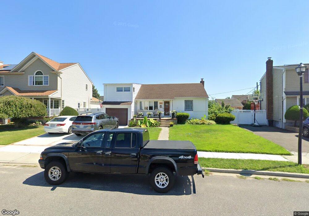
3991 Wellwood Rd Seaford, NY 11783
Estimated Value: $413,000 - $580,720
--
Bed
1
Bath
1,235
Sq Ft
$402/Sq Ft
Est. Value
About This Home
This home is located at 3991 Wellwood Rd, Seaford, NY 11783 and is currently estimated at $496,860, approximately $402 per square foot. 3991 Wellwood Rd is a home located in Nassau County with nearby schools including Michael F. Stokes Elementary School, J Fred Sparke Elementary School, and Island Trees Middle School.
Ownership History
Date
Name
Owned For
Owner Type
Purchase Details
Closed on
Dec 13, 2021
Sold by
Oates Thomas E and Oates Lucille
Bought by
Alesi James A and Alesi Linda J
Current Estimated Value
Home Financials for this Owner
Home Financials are based on the most recent Mortgage that was taken out on this home.
Original Mortgage
$243,000
Outstanding Balance
$223,496
Interest Rate
3.11%
Mortgage Type
New Conventional
Estimated Equity
$273,364
Create a Home Valuation Report for This Property
The Home Valuation Report is an in-depth analysis detailing your home's value as well as a comparison with similar homes in the area
Home Values in the Area
Average Home Value in this Area
Purchase History
| Date | Buyer | Sale Price | Title Company |
|---|---|---|---|
| Alesi James A | $325,000 | None Available |
Source: Public Records
Mortgage History
| Date | Status | Borrower | Loan Amount |
|---|---|---|---|
| Open | Alesi James A | $243,000 |
Source: Public Records
Tax History Compared to Growth
Tax History
| Year | Tax Paid | Tax Assessment Tax Assessment Total Assessment is a certain percentage of the fair market value that is determined by local assessors to be the total taxable value of land and additions on the property. | Land | Improvement |
|---|---|---|---|---|
| 2025 | $9,944 | $428 | $233 | $195 |
| 2024 | $3,148 | $428 | $233 | $195 |
| 2023 | $11,701 | $428 | $233 | $195 |
| 2022 | $11,701 | $428 | $233 | $195 |
| 2021 | $10,416 | $408 | $222 | $186 |
| 2020 | $6,858 | $680 | $498 | $182 |
| 2019 | $2,139 | $680 | $498 | $182 |
| 2018 | $4,176 | $680 | $0 | $0 |
| 2017 | $3,483 | $680 | $498 | $182 |
| 2016 | $5,469 | $680 | $498 | $182 |
| 2015 | $1,776 | $680 | $498 | $182 |
| 2014 | $1,776 | $680 | $498 | $182 |
| 2013 | $1,663 | $680 | $498 | $182 |
Source: Public Records
Map
Nearby Homes
- 3977 Wellwood Rd
- 4195 Florence Rd
- 3980 Kingsberry Rd
- 4278 Clarissa Rd
- 294 Swansdowne Dr
- 3805 Colonial Ct
- 4042 Old Post Rd
- 3901 Moore St
- 580 Heathcliff Dr
- 3842 Whitman St
- 243 Elm Dr S
- 8 Reading Ln
- 3 Brewster Gate
- 6 Regal Ln
- 647 Seamans Neck Rd
- 17 Rural Ln
- 15 Budd Ct
- 28 Eve Ln
- 4129 Duff Place
- 34 Dennis Ln
- 3997 Wellwood Rd
- 3983 Wellwood Rd
- 4048 Maywood Dr
- 4054 Maywood Dr
- 4042 Maywood Dr
- 4060 Maywood Dr
- 4019 Wellwood Rd
- 473 Piping Rock Rd
- 4006 Wellwood Rd
- 3990 Wellwood Rd
- 4036 Maywood Dr
- 3971 Wellwood Rd
- 4072 Maywood Dr
- 4020 Wellwood Rd
- 4030 Maywood Dr
- 3980 King Ct
- 4053 Maywood Dr
- 3962 Sandra Ln
- 3965 Wellwood Rd
- 445 Piping Rock Rd