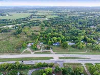
400 W Ray Fine Blvd Roland, OK 74954
Estimated payment $10,039/month
Total Views
15,476
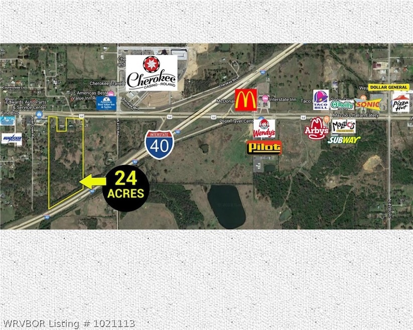
24
Acres
$79,167
Price per Acre
1,045,440
Sq Ft Lot
Highlights
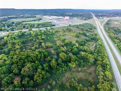
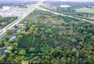
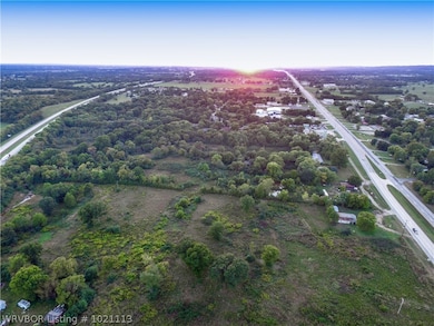
- 24 Acre Lot
- Creek or Stream
- Level Lot
- Partially Wooded Lot
About This Lot
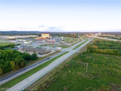
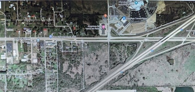
Development Opportunity !!! Calling all Developers, Investors, Entrepreneurs, & Determined Dream Chasers. 24 Acres of Opportunity waiting to be discovered. This property comes w/ Major Hwy Frontage / Visibility, Hwy Intersection, & sandwiched between Hwy 64 & Interstate 40, Easy access to I-40. Located in an area prime for growth, this property is 4 miles West of the Ark./OK. State Line & minutes from Ft. Smith, Ar. population 88,133 (2016 census) Property is just South of a major Casino, & Fuel Stop.
Property Details
Property Type
- Land
Est. Annual Taxes
- $535
Lot Details
- 24 Acre Lot
- Property fronts a highway
- Creek or Stream
- Level Lot
- Partially Wooded Lot
- May Be Possible The Lot Can Be Split Into 2+ Parcels
Location
- Outside City Limits
Schools
- Roland Elementary And Middle School
- Roland High School
Utilities
- Not Connected to Water Source
- Septic Tank
Listing and Financial Details
- Tax Lot 24 acres
- Assessor Parcel Number 0000-27-011-026-0-018-00
Map
Create a Home Valuation Report for This Property
The Home Valuation Report is an in-depth analysis detailing your home's value as well as a comparison with similar homes in the area
Home Values in the Area
Average Home Value in this Area
Tax History
| Year | Tax Paid | Tax Assessment Tax Assessment Total Assessment is a certain percentage of the fair market value that is determined by local assessors to be the total taxable value of land and additions on the property. | Land | Improvement |
|---|---|---|---|---|
| 2024 | $737 | $8,281 | $1,584 | $6,697 |
| 2023 | $737 | $8,041 | $1,584 | $6,457 |
| 2022 | $688 | $7,806 | $1,584 | $6,222 |
| 2021 | $675 | $7,579 | $1,584 | $5,995 |
| 2020 | $686 | $7,535 | $1,574 | $5,961 |
| 2019 | $666 | $7,315 | $1,524 | $5,791 |
| 2018 | $594 | $7,102 | $3,740 | $3,362 |
| 2017 | $535 | $6,276 | $3,740 | $2,536 |
| 2016 | $512 | $6,094 | $3,740 | $2,354 |
| 2015 | $486 | $5,917 | $3,740 | $2,177 |
| 2014 | $484 | $5,882 | $3,809 | $2,073 |
Source: Public Records
Property History
| Date | Event | Price | List to Sale | Price per Sq Ft |
|---|---|---|---|---|
| 11/11/2025 11/11/25 | For Sale | $2,500,000 | -3.8% | -- |
| 10/04/2018 10/04/18 | For Sale | $2,600,000 | -- | -- |
Source: Western River Valley Board of REALTORS®
Purchase History
| Date | Type | Sale Price | Title Company |
|---|---|---|---|
| Warranty Deed | -- | None Available |
Source: Public Records
Source: Western River Valley Board of REALTORS®
MLS Number: 1021113
APN: 0000-27-011-026-0-018-00
Nearby Homes
- 405 W Ray Fine Blvd
- 407 W Ray Fine Blvd
- TBD W Ray Fine Blvd
- 404 W Ray Fine Blvd
- 113 Cherokee Blvd
- 320 Neal Dr
- 111587 S 4760 Rd
- TBD U S Highway 64
- 0 N Cottonwood Rd
- 2000 N Cottonwood Rd
- 110907 S 4760 Rd
- 111182 S 4760 Rd
- 511 Mayfield Dr
- 505 Mayfield Dr
- 111324 S 4780 Rd
- 110127 S 4760 Rd
- 101 Hollow Dr
- 121 Shady Ln
- Lot 1 N 4780 Rd
- 200 S Jeff Ln
