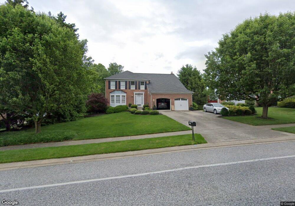
402 E Ring Factory Rd Bel Air, MD 21014
Estimated Value: $626,000 - $782,000
--
Bed
4
Baths
2,920
Sq Ft
$231/Sq Ft
Est. Value
About This Home
This home is located at 402 E Ring Factory Rd, Bel Air, MD 21014 and is currently estimated at $675,077, approximately $231 per square foot. 402 E Ring Factory Rd is a home located in Harford County with nearby schools including Homestead-Wakefield Elementary School, Bel Air Middle School, and Bel Air High School.
Ownership History
Date
Name
Owned For
Owner Type
Purchase Details
Closed on
Aug 15, 1990
Sold by
Ryland Group Inc The
Bought by
Watson Ronnie R and Watson Sharon
Current Estimated Value
Home Financials for this Owner
Home Financials are based on the most recent Mortgage that was taken out on this home.
Original Mortgage
$120,000
Interest Rate
10.08%
Purchase Details
Closed on
Apr 20, 1990
Sold by
Bel Air Land Development Iv
Bought by
Ryland Group Inc The
Create a Home Valuation Report for This Property
The Home Valuation Report is an in-depth analysis detailing your home's value as well as a comparison with similar homes in the area
Home Values in the Area
Average Home Value in this Area
Purchase History
| Date | Buyer | Sale Price | Title Company |
|---|---|---|---|
| Watson Ronnie R | $226,100 | -- | |
| Ryland Group Inc The | $165,700 | -- |
Source: Public Records
Mortgage History
| Date | Status | Borrower | Loan Amount |
|---|---|---|---|
| Closed | Watson Ronnie R | $120,000 |
Source: Public Records
Tax History Compared to Growth
Tax History
| Year | Tax Paid | Tax Assessment Tax Assessment Total Assessment is a certain percentage of the fair market value that is determined by local assessors to be the total taxable value of land and additions on the property. | Land | Improvement |
|---|---|---|---|---|
| 2025 | $6,041 | $578,700 | $114,500 | $464,200 |
| 2024 | $6,041 | $554,267 | $0 | $0 |
| 2023 | $5,775 | $529,833 | $0 | $0 |
| 2022 | $5,508 | $505,400 | $114,500 | $390,900 |
| 2021 | $11,017 | $482,733 | $0 | $0 |
| 2020 | $5,301 | $460,067 | $0 | $0 |
| 2019 | $5,048 | $437,400 | $120,900 | $316,500 |
| 2018 | $5,002 | $437,400 | $120,900 | $316,500 |
| 2017 | $5,002 | $437,400 | $0 | $0 |
| 2016 | -- | $448,400 | $0 | $0 |
| 2015 | $4,868 | $440,833 | $0 | $0 |
| 2014 | $4,868 | $433,267 | $0 | $0 |
Source: Public Records
Map
Nearby Homes
- 12 Overbrook Ln
- 4 Ashley Way
- 1308 Saratoga Dr
- 1039 Wingate Ct
- 916 Cheswold Ct
- 1219 Starmount Ln
- 906 Whispering Ridge Ln
- 12 Lexington Rd
- 4 Colonial Rd
- 231 E Belcrest Rd
- 123 Wakely Terrace
- 400 Idlewild Rd
- 1818 Selvin Dr Unit 202
- 3 Forest Dr
- 1312 Scottsdale Dr Unit H
- 1314 Scottsdale Dr Unit G
- 1310 Scottsdale Dr Unit R
- 1600 Martha Ct Unit 304
- 1600 Martha Ct Unit 301
- 1307 Scottsdale Dr Unit J
- 404 E Ring Factory Rd
- 400 E Ring Factory Rd
- 406 E Ring Factory Rd
- 5 E Brook Hill Ct
- 3 E Brook Hill Ct
- 401 E Ring Factory Rd
- 399 E Ring Factory Rd
- 801 N Pine Ridge Ct
- 1 E Brook Hill Ct
- 408 E Ring Factory Rd
- 111 Brandywine Place
- 11 E Brook Hill Ct
- 803 N Pine Ridge Ct
- 800 N Pine Ridge Ct
- 1001 Redbrook Ct
- 13 E Brook Hill Ct
- 805 N Pine Ridge Ct
- 410 E Ring Factory Rd
- 4 E Brook Hill Ct
- 110 Brandywine Place