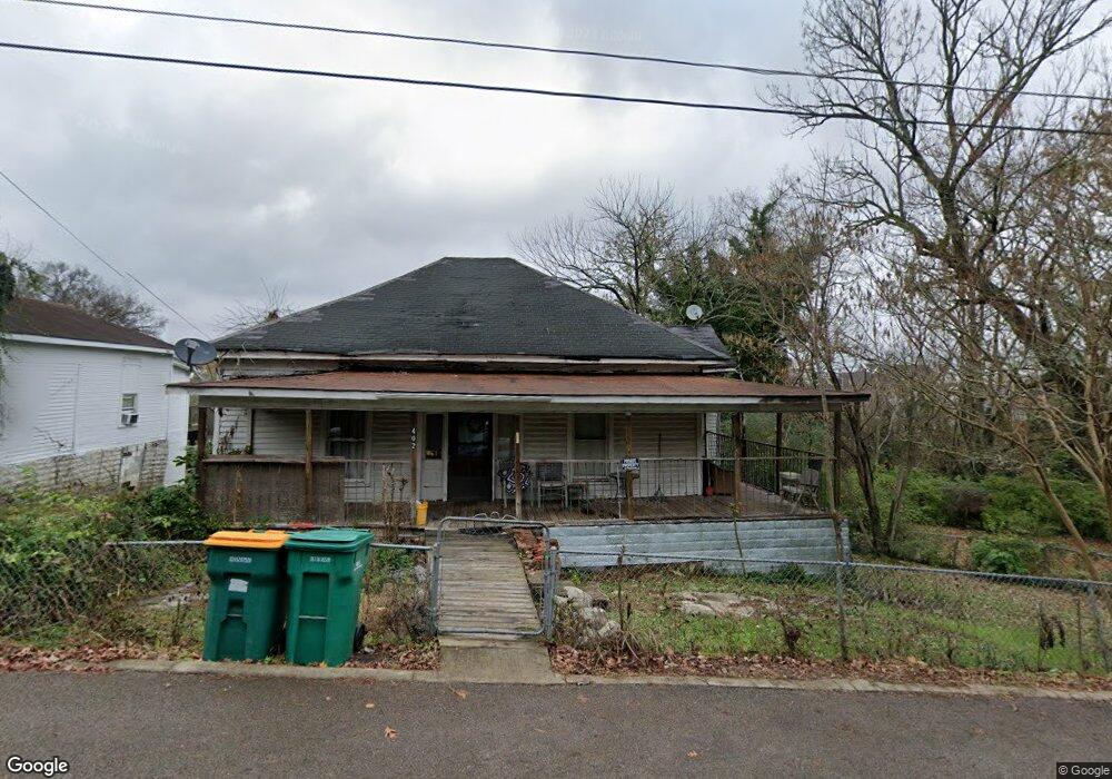
402 Maple St Lewisburg, TN 37091
Estimated Value: $99,000 - $164,000
--
Bed
1
Bath
1,103
Sq Ft
$107/Sq Ft
Est. Value
About This Home
This home is located at 402 Maple St, Lewisburg, TN 37091 and is currently estimated at $118,141, approximately $107 per square foot. 402 Maple St is a home located in Marshall County with nearby schools including Marshall Elementary School, Oak Grove Elementary School, and Westhills Elementary School.
Ownership History
Date
Name
Owned For
Owner Type
Purchase Details
Closed on
May 27, 2011
Sold by
Wentzel Dennis
Bought by
Robinson Wendy
Current Estimated Value
Purchase Details
Closed on
Dec 28, 2007
Bought by
Wentzel Dennis Jeremy Wentzel
Purchase Details
Closed on
Sep 11, 2002
Sold by
Carl Stogner and Carl Delores
Bought by
Ralph Fuller
Purchase Details
Closed on
Sep 30, 1998
Sold by
Eugene Salisbury
Bought by
Carl Stogner and Carl Delores
Purchase Details
Closed on
Mar 14, 1994
Sold by
Poarch William L
Bought by
Eugene Salisbury
Purchase Details
Closed on
Jan 7, 1991
Bought by
Poarch William L and Poarch Birdie
Purchase Details
Closed on
Jun 5, 1989
Bought by
Poarch Carl
Create a Home Valuation Report for This Property
The Home Valuation Report is an in-depth analysis detailing your home's value as well as a comparison with similar homes in the area
Home Values in the Area
Average Home Value in this Area
Purchase History
| Date | Buyer | Sale Price | Title Company |
|---|---|---|---|
| Robinson Wendy | $31,200 | -- | |
| Wentzel Dennis Jeremy Wentzel | $23,000 | -- | |
| Ralph Fuller | $17,500 | -- | |
| Carl Stogner | $18,500 | -- | |
| Eugene Salisbury | -- | -- | |
| Poarch William L | $12,500 | -- | |
| Poarch Carl | $13,000 | -- |
Source: Public Records
Tax History Compared to Growth
Tax History
| Year | Tax Paid | Tax Assessment Tax Assessment Total Assessment is a certain percentage of the fair market value that is determined by local assessors to be the total taxable value of land and additions on the property. | Land | Improvement |
|---|---|---|---|---|
| 2024 | -- | $13,575 | $2,500 | $11,075 |
| 2023 | $421 | $13,575 | $2,500 | $11,075 |
| 2022 | $421 | $13,575 | $2,500 | $11,075 |
| 2021 | $434 | $9,325 | $1,500 | $7,825 |
| 2020 | $434 | $9,325 | $1,500 | $7,825 |
| 2019 | $420 | $9,325 | $1,500 | $7,825 |
| 2018 | $416 | $9,325 | $1,500 | $7,825 |
| 2017 | $416 | $9,325 | $1,500 | $7,825 |
| 2016 | $404 | $7,875 | $1,375 | $6,500 |
| 2015 | $368 | $7,875 | $1,375 | $6,500 |
| 2014 | $368 | $7,875 | $1,375 | $6,500 |
Source: Public Records
Map
Nearby Homes
- 518 Maple St
- 525 Maple St
- 215 5th Ave N
- 610 Forrest St
- 316 Haynes St
- 726 Thomas Ave
- 0 New Lake Rd Unit RTC3030964
- 416 1st Ave N
- 319 E Hill Ave
- 640 6th Ave S
- 543 2nd Ave N
- 535 Clayton Ave
- 632 Colburn Dr
- 594 5th Ave N
- 630 6th Ave N
- 627 6th Ave N
- 638 2nd Ave N
- 319 Greenwood St
- 231 Greenwood St
- 966 Berry St