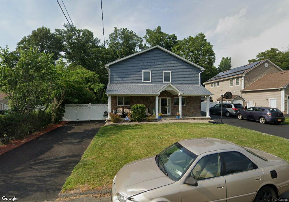
41 Reld Dr Pearl River, NY 10965
Estimated Value: $844,000 - $1,073,000
4
Beds
3
Baths
3,184
Sq Ft
$298/Sq Ft
Est. Value
About This Home
This home is located at 41 Reld Dr, Pearl River, NY 10965 and is currently estimated at $948,654, approximately $297 per square foot. 41 Reld Dr is a home located in Rockland County with nearby schools including Pearl River High School and St Margaret School.
Ownership History
Date
Name
Owned For
Owner Type
Purchase Details
Closed on
Jan 23, 2009
Sold by
Maucione Michael J and Maucione Dawn M
Bought by
Maucione Michael J and Maucione Dawn M
Current Estimated Value
Home Financials for this Owner
Home Financials are based on the most recent Mortgage that was taken out on this home.
Original Mortgage
$250,000
Outstanding Balance
$158,008
Interest Rate
5.26%
Mortgage Type
Stand Alone Refi Refinance Of Original Loan
Estimated Equity
$790,646
Purchase Details
Closed on
May 2, 1996
Sold by
Mauro Diana and Greco Diana
Bought by
Brucale Dawn M and Maucione Michael J
Home Financials for this Owner
Home Financials are based on the most recent Mortgage that was taken out on this home.
Original Mortgage
$127,000
Interest Rate
7.67%
Mortgage Type
Construction
Create a Home Valuation Report for This Property
The Home Valuation Report is an in-depth analysis detailing your home's value as well as a comparison with similar homes in the area
Home Values in the Area
Average Home Value in this Area
Purchase History
| Date | Buyer | Sale Price | Title Company |
|---|---|---|---|
| Maucione Michael J | -- | Fidelity National Title Insu | |
| Maucione Michael J | -- | Fidelity National Title Insu | |
| Brucale Dawn M | $177,000 | Nations Title Ins Of Ny Inc | |
| Brucale Dawn M | $177,000 | Nations Title Ins Of Ny Inc |
Source: Public Records
Mortgage History
| Date | Status | Borrower | Loan Amount |
|---|---|---|---|
| Open | Maucione Michael J | $250,000 | |
| Closed | Maucione Michael J | $250,000 | |
| Closed | Brucale Dawn M | $127,000 |
Source: Public Records
Tax History Compared to Growth
Tax History
| Year | Tax Paid | Tax Assessment Tax Assessment Total Assessment is a certain percentage of the fair market value that is determined by local assessors to be the total taxable value of land and additions on the property. | Land | Improvement |
|---|---|---|---|---|
| 2024 | $18,059 | $230,000 | $45,200 | $184,800 |
| 2023 | $18,059 | $230,000 | $45,200 | $184,800 |
| 2022 | $5,633 | $230,000 | $45,200 | $184,800 |
| 2021 | $15,404 | $230,000 | $45,200 | $184,800 |
| 2020 | $14,766 | $230,000 | $45,200 | $184,800 |
| 2019 | $5,257 | $230,000 | $45,200 | $184,800 |
| 2018 | $14,029 | $230,000 | $45,200 | $184,800 |
| 2017 | $13,554 | $230,000 | $45,200 | $184,800 |
| 2016 | $13,127 | $230,000 | $45,200 | $184,800 |
| 2015 | -- | $230,000 | $45,200 | $184,800 |
| 2014 | -- | $230,000 | $45,200 | $184,800 |
Source: Public Records
Map
Nearby Homes
- 14 Staubitz Ave
- 87 Pinto Rd
- 4 Brown Dr
- 46 Cara Dr
- 110 Orchid Dr
- 5 Hillaire Place
- 352 Holt Dr
- 250 Blauvelt Rd
- 165 Forest Ave
- 221 N Middletown Rd Unit F
- 452 Somerset Dr Unit F
- 854 E Crooked Hill Rd Unit 854
- 432 Somerset Dr Unit M
- 359 Orangeburg Rd
- 4 Sunrise Ln
- 12 E Nauraushaun Ave
- 137 Blauvelt Rd
- 73 Bogert Ave
- 86 Braunsdorf Rd
- 74 Oldert Dr