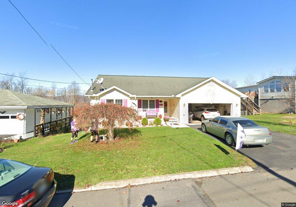
410 Jones St Nanticoke, PA 18634
Estimated Value: $156,000 - $282,000
--
Bed
--
Bath
1,272
Sq Ft
$163/Sq Ft
Est. Value
About This Home
This home is located at 410 Jones St, Nanticoke, PA 18634 and is currently estimated at $206,719, approximately $162 per square foot. 410 Jones St is a home located in Luzerne County with nearby schools including Kennedy Early Childhood Center, Nanticoke Area Elementary Center Center, and Greater Nanticoke Area Senior High School.
Ownership History
Date
Name
Owned For
Owner Type
Purchase Details
Closed on
Apr 2, 2018
Sold by
Werts Debra A
Bought by
Cardinale Stanley and Cardinale Mia
Current Estimated Value
Home Financials for this Owner
Home Financials are based on the most recent Mortgage that was taken out on this home.
Original Mortgage
$124,800
Outstanding Balance
$107,226
Interest Rate
4.4%
Mortgage Type
New Conventional
Estimated Equity
$99,493
Purchase Details
Closed on
Aug 21, 2007
Sold by
Kafchinski Stanley M and Kafchinski Joanna M
Bought by
Werts Debra A
Home Financials for this Owner
Home Financials are based on the most recent Mortgage that was taken out on this home.
Original Mortgage
$120,000
Interest Rate
6.78%
Mortgage Type
Purchase Money Mortgage
Create a Home Valuation Report for This Property
The Home Valuation Report is an in-depth analysis detailing your home's value as well as a comparison with similar homes in the area
Home Values in the Area
Average Home Value in this Area
Purchase History
| Date | Buyer | Sale Price | Title Company |
|---|---|---|---|
| Cardinale Stanley | $156,000 | Silk Title & Escrow Llc | |
| Werts Debra A | $150,000 | None Available |
Source: Public Records
Mortgage History
| Date | Status | Borrower | Loan Amount |
|---|---|---|---|
| Open | Cardinale Stanley | $124,800 | |
| Previous Owner | Werts Debra A | $120,000 |
Source: Public Records
Tax History Compared to Growth
Tax History
| Year | Tax Paid | Tax Assessment Tax Assessment Total Assessment is a certain percentage of the fair market value that is determined by local assessors to be the total taxable value of land and additions on the property. | Land | Improvement |
|---|---|---|---|---|
| 2025 | $4,166 | $159,700 | $23,200 | $136,500 |
| 2024 | $4,166 | $159,700 | $23,200 | $136,500 |
| 2023 | $4,109 | $159,700 | $23,200 | $136,500 |
| 2022 | $3,919 | $159,700 | $23,200 | $136,500 |
| 2021 | $3,834 | $159,700 | $23,200 | $136,500 |
| 2020 | $3,834 | $159,700 | $23,200 | $136,500 |
| 2019 | $3,565 | $149,700 | $23,200 | $126,500 |
| 2018 | $3,503 | $149,700 | $23,200 | $126,500 |
| 2017 | $3,440 | $149,700 | $23,200 | $126,500 |
| 2016 | $1,498 | $149,700 | $23,200 | $126,500 |
| 2015 | $2,071 | $149,700 | $23,200 | $126,500 |
| 2014 | $2,071 | $149,700 | $23,200 | $126,500 |
Source: Public Records
Map
Nearby Homes
- 25 Cherry Dr
- 138 Espy St
- 0 Middle Rd
- 418 E Washington St
- 416 E Washington St
- 246 E Washington St
- 65 W South St
- 257 E Ridge St
- 0 Enterprise St
- 24 Varsity Dr
- 23 Varsity Dr
- 22 Varsity Dr
- 21 Brian Place
- 20 Brian Place
- 131 W Union St
- 317 E Green St
- 339 E Broad St
- 333 State St
- 200 W Union St
- 22 S Walnut St