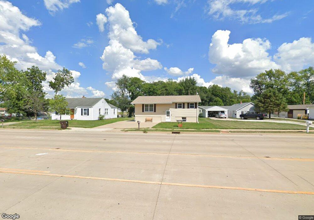
4108 Airport Rd Peoria, IL 61607
Estimated Value: $170,622 - $187,000
2
Beds
2
Baths
960
Sq Ft
$188/Sq Ft
Est. Value
About This Home
This home is located at 4108 Airport Rd, Peoria, IL 61607 and is currently estimated at $180,406, approximately $187 per square foot. 4108 Airport Rd is a home located in Peoria County with nearby schools including Oak Grove School, Oak Grove West School, and Limestone Community High School.
Ownership History
Date
Name
Owned For
Owner Type
Purchase Details
Closed on
May 28, 2021
Sold by
Hampton Donald J and Hampton Diana L
Bought by
Davidson-Crow Jessica
Current Estimated Value
Home Financials for this Owner
Home Financials are based on the most recent Mortgage that was taken out on this home.
Original Mortgage
$127,645
Outstanding Balance
$115,567
Interest Rate
2.9%
Mortgage Type
FHA
Estimated Equity
$64,839
Purchase Details
Closed on
Jul 8, 2020
Sold by
Hampton Donald J and Hampton Diana L
Bought by
Hampton Donald J and Hampton Diana L
Create a Home Valuation Report for This Property
The Home Valuation Report is an in-depth analysis detailing your home's value as well as a comparison with similar homes in the area
Home Values in the Area
Average Home Value in this Area
Purchase History
| Date | Buyer | Sale Price | Title Company |
|---|---|---|---|
| Davidson-Crow Jessica | $130,000 | Tilton Law Office | |
| Hampton Donald J | -- | None Listed On Document |
Source: Public Records
Mortgage History
| Date | Status | Borrower | Loan Amount |
|---|---|---|---|
| Open | Davidson-Crow Jessica | $127,645 |
Source: Public Records
Tax History Compared to Growth
Tax History
| Year | Tax Paid | Tax Assessment Tax Assessment Total Assessment is a certain percentage of the fair market value that is determined by local assessors to be the total taxable value of land and additions on the property. | Land | Improvement |
|---|---|---|---|---|
| 2024 | $3,490 | $41,680 | $6,960 | $34,720 |
| 2023 | $3,247 | $38,590 | $6,440 | $32,150 |
| 2022 | $3,110 | $36,760 | $6,040 | $30,720 |
| 2021 | $2,983 | $35,350 | $5,810 | $29,540 |
| 2020 | $2,816 | $34,660 | $5,700 | $28,960 |
| 2019 | $2,808 | $34,660 | $5,700 | $28,960 |
| 2018 | $2,743 | $34,640 | $5,690 | $28,950 |
| 2017 | $2,847 | $34,990 | $5,750 | $29,240 |
| 2016 | $2,861 | $35,350 | $5,810 | $29,540 |
| 2015 | $2,706 | $34,660 | $5,700 | $28,960 |
| 2014 | $2,659 | $34,070 | $5,610 | $28,460 |
| 2013 | -- | $34,070 | $5,610 | $28,460 |
Source: Public Records
Map
Nearby Homes
- 4206 S Granville Ave
- 11 Sandalwood Ln
- 1 New Salem Rd
- 3807 S Lafayette Ave
- 29 Gulf Stream Ave
- 4622 Meadow Ln
- 0 Correll Ct
- 811 W Garfield Ave
- 1000 Taylor Ln
- 605 Franklin Ave
- 5221 W Cisna Rd
- 0 S Skyway Rd
- 5914 Madison St
- 6113 S Adams St
- 7113 Depot St
- LOT 26 W Sunflower Dr
- 5115 W Harp Hollow Rd
- #8 W Harp Hollow Rd
- 5125 S Alaska Rd
- 5801 S Jefferson St
- 4108 S Airport Rd
- 4104 Airport Rd
- 4112 Airport Rd
- 4116 Airport Rd
- 5408 W Catherine Ave
- 5404 W Catherine Ave
- 4026 Airport Rd
- 4120 Airport Rd
- 4022 Airport Rd
- 4022 S Airport Rd
- 4125 S Paramount Rd
- 5401 W Catherine Ave
- 4020 Airport Rd
- 4129 S Paramount Rd
- 4128 S Airport Rd
- 4019 S Paramount Rd
- 4016 Airport Rd
- 4203 S Paramount Rd
- 4202 Airport Rd
- 4012 Airport Rd