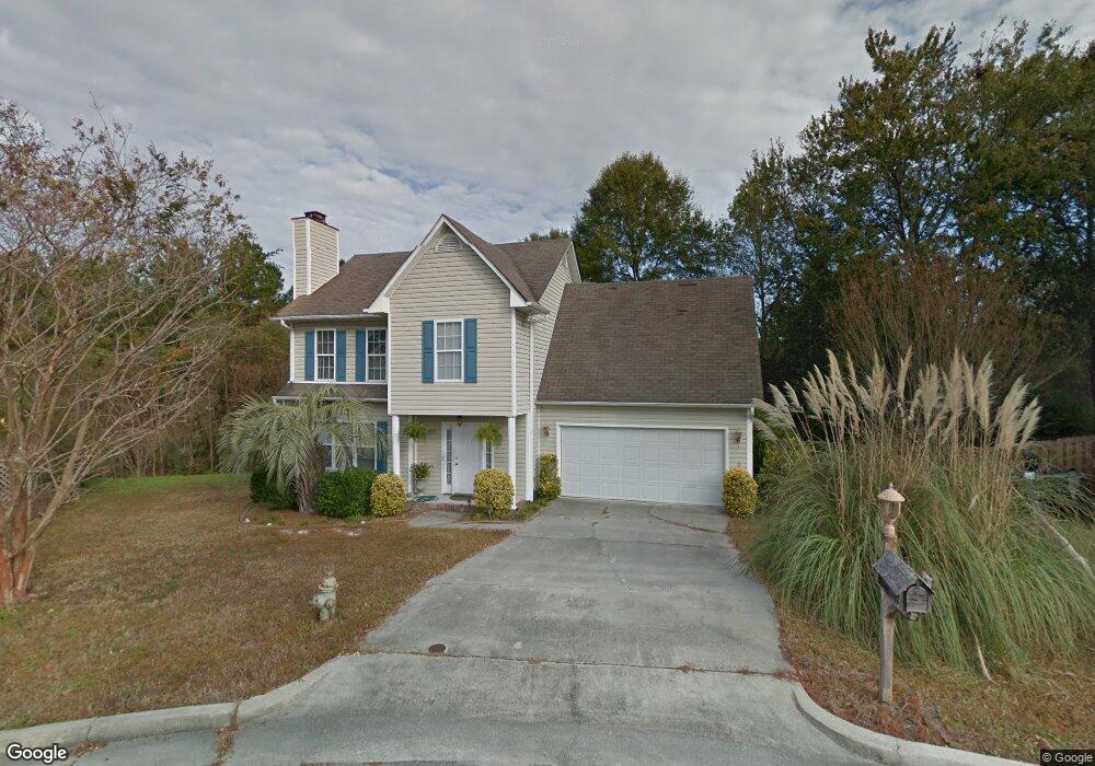
4171 Woodstock Dr Wilmington, NC 28412
Carriage Hills NeighborhoodEstimated Value: $390,000 - $408,436
3
Beds
3
Baths
1,785
Sq Ft
$225/Sq Ft
Est. Value
About This Home
This home is located at 4171 Woodstock Dr, Wilmington, NC 28412 and is currently estimated at $402,359, approximately $225 per square foot. 4171 Woodstock Dr is a home located in New Hanover County with nearby schools including Pine Valley Elementary School, Williston Middle School, and John T. Hoggard High School.
Ownership History
Date
Name
Owned For
Owner Type
Purchase Details
Closed on
Nov 29, 2005
Sold by
Roberson Antoinette Marie and Roberson Lendy S
Bought by
Mcgowan J Bruce
Current Estimated Value
Purchase Details
Closed on
Sep 23, 2002
Sold by
Chardonn Jonnie C Arthur L
Bought by
Roberson Antoinette M Lendy S
Purchase Details
Closed on
Jan 22, 1999
Sold by
Baker Precythe Development Co
Bought by
Chardonn Jonnie C Arthur
Purchase Details
Closed on
Jun 20, 1997
Sold by
Baker Precythe Development Co
Bought by
Baker Precythe Development Co
Purchase Details
Closed on
Dec 28, 1995
Sold by
Baker Precythe Development Co
Bought by
Stonington Poa
Purchase Details
Closed on
Nov 28, 1995
Sold by
Baker Precythe Development Co
Bought by
Stonington Poa
Purchase Details
Closed on
Aug 31, 1994
Sold by
Clayton Group (The)
Bought by
Baker Precythe Development Co
Create a Home Valuation Report for This Property
The Home Valuation Report is an in-depth analysis detailing your home's value as well as a comparison with similar homes in the area
Home Values in the Area
Average Home Value in this Area
Purchase History
| Date | Buyer | Sale Price | Title Company |
|---|---|---|---|
| Mcgowan J Bruce | $232,000 | None Available | |
| Roberson Antoinette M Lendy S | -- | -- | |
| Chardonn Jonnie C Arthur | $132,000 | -- | |
| Baker Precythe Development Co | -- | -- | |
| Stonington Poa | -- | -- | |
| Stonington Poa | -- | -- | |
| Baker Precythe Development Co | $405,000 | -- |
Source: Public Records
Tax History Compared to Growth
Tax History
| Year | Tax Paid | Tax Assessment Tax Assessment Total Assessment is a certain percentage of the fair market value that is determined by local assessors to be the total taxable value of land and additions on the property. | Land | Improvement |
|---|---|---|---|---|
| 2025 | $2,288 | $370,700 | $102,500 | $268,200 |
| 2023 | $2,288 | $263,000 | $78,600 | $184,400 |
| 2022 | $2,236 | $263,000 | $78,600 | $184,400 |
| 2021 | $2,251 | $263,000 | $78,600 | $184,400 |
| 2020 | $1,942 | $184,400 | $40,000 | $144,400 |
| 2019 | $1,942 | $184,400 | $40,000 | $144,400 |
| 2018 | $1,942 | $184,400 | $40,000 | $144,400 |
| 2017 | $1,942 | $184,400 | $40,000 | $144,400 |
| 2016 | $1,817 | $164,000 | $40,000 | $124,000 |
| 2015 | $1,737 | $164,000 | $40,000 | $124,000 |
| 2014 | $1,663 | $164,000 | $40,000 | $124,000 |
Source: Public Records
Map
Nearby Homes
- 1001 Avenshire Cir
- 1010 Avenshire Cir
- 1018 Avenshire Cir
- 1111 Avenshire Cir
- 4001 E Durant Ct
- 801 Saint Andrews Dr
- 119 Brascote Ln
- 1603 Bexley Dr
- 4406 Fireside Ct
- 4217 Ashley Park Dr
- 905 Haymarket Ln
- 1155 Groppo Cove
- 4414 Grey Oaks Ct
- 4422 Grey Oaks Ct
- 3831 Merestone Dr
- 3847 Merestone Dr
- 503 Night Hawk Dr
- 3669 Merestone Dr
- 4432 Regent Dr
- 4309 Tollington Dr
- 4175 Woodstock Dr
- 4167 Woodstock Dr
- 4162 Woodstock Dr
- 1501 Stockbridge Place
- 1509 Stockbridge Place
- 4166 Woodstock Dr
- 4170 Woodstock Dr
- 4174 Woodstock Dr
- 1405 Stockbridge Place
- 1502 Stockbridge Place
- 1513 Stockbridge Place
- 1506 Stockbridge Place
- 1414 Stockbridge Place
- 1510 Stockbridge Place
- 1401 Stockbridge Place
- 1003 Avenshire Cir
- 4187 Woodstock Dr
- 1004 Avenshire Cir
- 1421 Stonington Dr
- 1005 Avenshire Cir