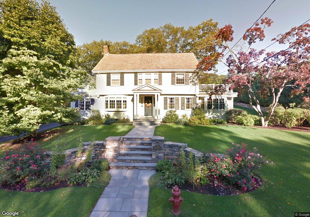
42 Howland Rd West Newton, MA 02465
West Newton NeighborhoodEstimated Value: $2,506,873 - $3,502,000
6
Beds
4
Baths
2,847
Sq Ft
$1,032/Sq Ft
Est. Value
About This Home
This home is located at 42 Howland Rd, West Newton, MA 02465 and is currently estimated at $2,937,468, approximately $1,031 per square foot. 42 Howland Rd is a home located in Middlesex County with nearby schools including Peirce Elementary School, F.A. Day Middle School, and Newton North High School.
Ownership History
Date
Name
Owned For
Owner Type
Purchase Details
Closed on
Aug 13, 2009
Sold by
Beecher Thomas R and Beecher Karin W
Bought by
Beecher Thomas R and Beecher Karin W
Current Estimated Value
Home Financials for this Owner
Home Financials are based on the most recent Mortgage that was taken out on this home.
Original Mortgage
$250,000
Interest Rate
5.36%
Purchase Details
Closed on
Jul 30, 2003
Sold by
Lert Peter W and Lert Erika N
Bought by
Beecher Karin W and Beecher Thomas R
Purchase Details
Closed on
Jun 1, 1998
Sold by
Mcmanmon Arthur T
Bought by
Lert Erika Nagy and Lert Peter W
Create a Home Valuation Report for This Property
The Home Valuation Report is an in-depth analysis detailing your home's value as well as a comparison with similar homes in the area
Home Values in the Area
Average Home Value in this Area
Purchase History
| Date | Buyer | Sale Price | Title Company |
|---|---|---|---|
| Beecher Thomas R | -- | -- | |
| Beecher Karin W | $1,195,500 | -- | |
| Lert Erika Nagy | $645,000 | -- |
Source: Public Records
Mortgage History
| Date | Status | Borrower | Loan Amount |
|---|---|---|---|
| Open | Lert Erika Nagy | $1,052,000 | |
| Closed | Lert Erika Nagy | $250,000 | |
| Closed | Lert Erika Nagy | $1,065,000 |
Source: Public Records
Tax History Compared to Growth
Tax History
| Year | Tax Paid | Tax Assessment Tax Assessment Total Assessment is a certain percentage of the fair market value that is determined by local assessors to be the total taxable value of land and additions on the property. | Land | Improvement |
|---|---|---|---|---|
| 2025 | $25,003 | $2,551,300 | $1,339,900 | $1,211,400 |
| 2024 | $24,176 | $2,477,000 | $1,300,900 | $1,176,100 |
| 2023 | $23,270 | $2,285,900 | $1,018,400 | $1,267,500 |
| 2022 | $22,267 | $2,116,600 | $943,000 | $1,173,600 |
| 2021 | $21,486 | $1,996,800 | $889,600 | $1,107,200 |
| 2020 | $20,847 | $1,996,800 | $889,600 | $1,107,200 |
| 2019 | $20,258 | $1,938,600 | $863,700 | $1,074,900 |
| 2018 | $19,692 | $1,820,000 | $779,000 | $1,041,000 |
| 2017 | $19,093 | $1,717,000 | $734,900 | $982,100 |
| 2016 | $18,261 | $1,604,700 | $686,800 | $917,900 |
| 2015 | $17,412 | $1,499,700 | $641,900 | $857,800 |
Source: Public Records
Map
Nearby Homes
- 39 Valentine Park
- 308 Prince St
- 18 Sewall St
- 40 Sewall St
- 10 Ruane Rd
- 318 Austin St Unit A
- 61 Lakeview Ave
- 123 Mount Vernon St Unit 2
- 123-125 Mount Vernon St
- 1640 Commonwealth Ave
- 12 Wiswall St
- 1430 Beacon St
- 4 Wiswall St
- 27 Cross St Unit 27
- 25 Allen Ave
- 29 Montclair Rd
- 115 Windsor Rd
- 0 Duncan Rd Unit 72925240
- 17 Gilbert St
- 1639 Washington St