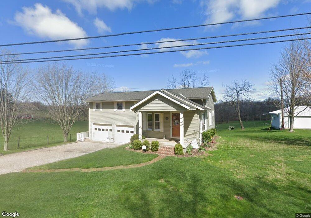
4205 Boggs Rd Zanesville, OH 43701
Estimated Value: $145,000
--
Bed
--
Bath
--
Sq Ft
6.85
Acres
About This Home
This home is located at 4205 Boggs Rd, Zanesville, OH 43701 and is currently estimated at $145,000. 4205 Boggs Rd is a home located in Muskingum County with nearby schools including National Road Elementary School, Zanesville Middle School, and Zanesville High School.
Ownership History
Date
Name
Owned For
Owner Type
Purchase Details
Closed on
Oct 16, 2018
Sold by
Shelly Janet L and Shelly Richard B
Bought by
Shelly Richard B and Shelly Janet L
Current Estimated Value
Purchase Details
Closed on
Jul 8, 2016
Bought by
Robert Joe Tom & Tom Life Estate
Home Financials for this Owner
Home Financials are based on the most recent Mortgage that was taken out on this home.
Interest Rate
3.41%
Purchase Details
Closed on
Apr 10, 2006
Sold by
Tom Robert and Tom Dorothy Ellen
Bought by
Tom Robert Joe
Create a Home Valuation Report for This Property
The Home Valuation Report is an in-depth analysis detailing your home's value as well as a comparison with similar homes in the area
Home Values in the Area
Average Home Value in this Area
Purchase History
| Date | Buyer | Sale Price | Title Company |
|---|---|---|---|
| Shelly Richard B | -- | None Available | |
| Robert Joe Tom & Tom Life Estate | $5,290 | -- | |
| Tom Robert Joe | -- | None Available | |
| Shelly Janet Louise | -- | None Available |
Source: Public Records
Mortgage History
| Date | Status | Borrower | Loan Amount |
|---|---|---|---|
| Closed | Robert Joe Tom & Tom Life Estate | -- |
Source: Public Records
Tax History Compared to Growth
Tax History
| Year | Tax Paid | Tax Assessment Tax Assessment Total Assessment is a certain percentage of the fair market value that is determined by local assessors to be the total taxable value of land and additions on the property. | Land | Improvement |
|---|---|---|---|---|
| 2024 | $987 | $24,920 | $22,155 | $2,765 |
| 2023 | $586 | $13,720 | $11,060 | $2,660 |
| 2022 | $578 | $13,720 | $11,060 | $2,660 |
| 2021 | $573 | $13,720 | $11,060 | $2,660 |
| 2020 | $519 | $11,970 | $9,625 | $2,345 |
| 2019 | $519 | $11,970 | $9,625 | $2,345 |
| 2018 | $508 | $11,970 | $9,625 | $2,345 |
| 2017 | $538 | $12,072 | $9,622 | $2,450 |
| 2016 | $534 | $14,070 | $10,710 | $3,360 |
| 2015 | $614 | $14,070 | $10,710 | $3,360 |
| 2013 | $674 | $13,860 | $10,710 | $3,150 |
Source: Public Records
Map
Nearby Homes
- 4460 East Pike
- 360 Walters Way
- 365 Walters Way
- 1605 Jackson Rd
- 130 Airport Rd
- 400 Spring Valley Dr
- 3620 Old Wheeling Rd
- 0 Sonora Rd Unit 225018643
- 0 Sonora Rd Unit 5125925
- 5180 Pine Valley Dr
- 310 Trappers Hollow Rd
- 2835 Adamsville Rd
- 1305 Bald Hill Rd
- 2870 Cody Dr
- 2755 N Lawndale Place
- 2397 Adamsville Rd
- 496 Pleasant Grove Rd
- 240 Mockingbird Hill
- 6265 Canterbury Way Unit LOT 30
- 2850 Watson Way