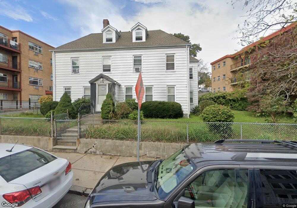
421 River St Mattapan, MA 02126
Mattapan Square NeighborhoodEstimated Value: $683,000 - $846,702
4
Beds
2
Baths
2,110
Sq Ft
$360/Sq Ft
Est. Value
About This Home
This home is located at 421 River St, Mattapan, MA 02126 and is currently estimated at $760,426, approximately $360 per square foot. 421 River St is a home located in Suffolk County with nearby schools including KIPP Academy Boston Charter School, Berea Seventh-day Adventist Academy, and St. Mary of the Hills School.
Ownership History
Date
Name
Owned For
Owner Type
Purchase Details
Closed on
Oct 11, 2019
Sold by
Olivier Ludner
Bought by
Olivier Holdings Llc
Current Estimated Value
Purchase Details
Closed on
Mar 30, 2001
Sold by
Johnson Ida B
Bought by
Olivier Ludner and Olivier Marie Y
Home Financials for this Owner
Home Financials are based on the most recent Mortgage that was taken out on this home.
Original Mortgage
$183,200
Interest Rate
6.96%
Mortgage Type
Purchase Money Mortgage
Create a Home Valuation Report for This Property
The Home Valuation Report is an in-depth analysis detailing your home's value as well as a comparison with similar homes in the area
Home Values in the Area
Average Home Value in this Area
Purchase History
| Date | Buyer | Sale Price | Title Company |
|---|---|---|---|
| Olivier Holdings Llc | -- | -- | |
| Olivier Ludner | $229,000 | -- |
Source: Public Records
Mortgage History
| Date | Status | Borrower | Loan Amount |
|---|---|---|---|
| Previous Owner | Olivier Ludner | $183,200 | |
| Previous Owner | Olivier Ludner | $17,000 |
Source: Public Records
Tax History Compared to Growth
Tax History
| Year | Tax Paid | Tax Assessment Tax Assessment Total Assessment is a certain percentage of the fair market value that is determined by local assessors to be the total taxable value of land and additions on the property. | Land | Improvement |
|---|---|---|---|---|
| 2025 | $8,261 | $713,400 | $223,100 | $490,300 |
| 2024 | $7,750 | $711,000 | $228,700 | $482,300 |
| 2023 | $7,069 | $658,200 | $211,700 | $446,500 |
| 2022 | $7,161 | $658,200 | $211,700 | $446,500 |
| 2021 | $6,625 | $620,900 | $199,700 | $421,200 |
| 2020 | $5,424 | $513,600 | $195,400 | $318,200 |
| 2019 | $4,832 | $458,400 | $147,800 | $310,600 |
| 2018 | $4,532 | $432,400 | $147,800 | $284,600 |
| 2017 | $4,402 | $415,700 | $147,800 | $267,900 |
| 2016 | $4,274 | $388,500 | $147,800 | $240,700 |
| 2015 | $3,921 | $323,800 | $124,000 | $199,800 |
| 2014 | $3,637 | $289,100 | $124,000 | $165,100 |
Source: Public Records
Map
Nearby Homes
- 24 Constitution Rd
- 10 Briarcliff Terrace
- 4 Crossman St Unit 4
- 1465 Blue Hill Ave
- 11 French St
- 95 Woodhaven St
- 84 Blue Hills Pkwy
- 32 Violet St
- 27 Hawthorn Rd
- 48-50 Rockdale St
- 16 Blue Hill Ave
- 10 Brockton St
- 770 Cummins Hwy Unit 1
- 770 Cummins Hwy Unit 22
- 15 Fairfax Rd
- 333 Eliot St
- 32 Columbine Rd
- 128 Blue Hills Pkwy
- 90 Hollingsworth St
- 214 Brook Rd
- 425 River St
- 415 River St
- 422 River St Unit 13
- 422 River St
- 422 River St Unit 9a
- 422 River St Unit 15
- 422 River St Unit 9
- 422 River St Unit 5
- 422 River St
- 430 River St
- 61 Fremont St
- 438 River St
- 7 Riverbank Place
- 11 Delnore Place
- 55 Fremont St
- 449 River St
- 64 Fremont St
- 68 Fremont St
- 401 River St
- 401 River St Unit 1