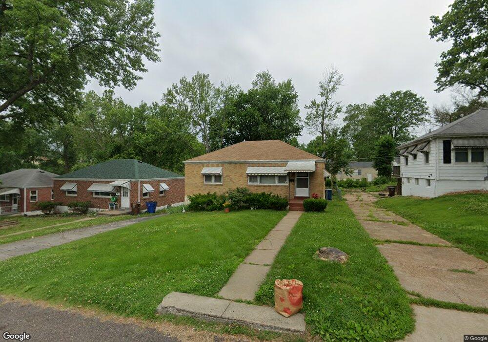
427 Warfield Ave Saint Louis, MO 63135
Estimated Value: $64,530 - $97,000
2
Beds
1
Bath
840
Sq Ft
$100/Sq Ft
Est. Value
About This Home
This home is located at 427 Warfield Ave, Saint Louis, MO 63135 and is currently estimated at $83,633, approximately $99 per square foot. 427 Warfield Ave is a home located in St. Louis County with nearby schools including Ferguson Middle School, Johnson Wabash Elementary School, and McCluer High School.
Ownership History
Date
Name
Owned For
Owner Type
Purchase Details
Closed on
Mar 7, 2024
Sold by
2011 Cards Llc
Bought by
Hello Walls Llc
Current Estimated Value
Purchase Details
Closed on
Sep 28, 2023
Sold by
Clark Charlene
Bought by
2011 Cards Llc
Purchase Details
Closed on
Jan 28, 1999
Sold by
Royer Lillian S and Rose Cynthia Rose
Bought by
Clark Charlene
Home Financials for this Owner
Home Financials are based on the most recent Mortgage that was taken out on this home.
Original Mortgage
$46,000
Interest Rate
6.85%
Create a Home Valuation Report for This Property
The Home Valuation Report is an in-depth analysis detailing your home's value as well as a comparison with similar homes in the area
Home Values in the Area
Average Home Value in this Area
Purchase History
| Date | Buyer | Sale Price | Title Company |
|---|---|---|---|
| Hello Walls Llc | -- | None Listed On Document | |
| 2011 Cards Llc | -- | None Listed On Document | |
| Clark Charlene | $46,000 | -- |
Source: Public Records
Mortgage History
| Date | Status | Borrower | Loan Amount |
|---|---|---|---|
| Previous Owner | Clark Charlene | $46,000 |
Source: Public Records
Tax History Compared to Growth
Tax History
| Year | Tax Paid | Tax Assessment Tax Assessment Total Assessment is a certain percentage of the fair market value that is determined by local assessors to be the total taxable value of land and additions on the property. | Land | Improvement |
|---|---|---|---|---|
| 2025 | $952 | $16,510 | $1,940 | $14,570 |
| 2024 | $952 | $12,960 | $1,560 | $11,400 |
| 2023 | $952 | $12,960 | $1,560 | $11,400 |
| 2022 | $795 | $9,440 | $1,160 | $8,280 |
| 2021 | $770 | $9,440 | $1,160 | $8,280 |
| 2020 | $909 | $10,070 | $1,560 | $8,510 |
| 2019 | $892 | $10,070 | $1,560 | $8,510 |
| 2018 | $752 | $7,530 | $1,200 | $6,330 |
| 2017 | $738 | $7,530 | $1,200 | $6,330 |
| 2016 | $933 | $9,450 | $1,580 | $7,870 |
| 2015 | $939 | $9,450 | $1,580 | $7,870 |
| 2014 | $951 | $9,470 | $1,620 | $7,850 |
Source: Public Records
Map
Nearby Homes
- 439 Warford Ave
- 614 January Ave
- 415 Warford Ave
- 218 N Marguerite Ave
- 806 Rolwes Ave
- 138 N Marguerite Ave
- 601 Chanslor Ave
- 324 Newell Dr
- 213 Henquin Dr
- 222 Wooster Dr
- 127 Thoroughman Ave
- 810 Airport Rd
- 53 N Dade Ave
- 111 Royal Ave
- 116 Henquin Dr
- 117 Henquin Dr
- 8027 Aline Ave
- 28 N Harvey Ave
- 6130 Wulff Dr
- 716 Nancy Place
- 423 Warfield Ave
- 431 Warfield Ave
- 419 Warfield Ave
- 437 Warfield Ave
- 422 Jehling Dr
- 426 Jehling Dr
- 418 Jehling Dr
- 415 Warfield Ave
- 439 Warfield Ave
- 430 Jehling Dr
- 414 Jehling Dr
- 428 Warfield Ave
- 432 Warfield Ave
- 424 Warfield Ave
- 434 Jehling Dr
- 436 Warfield Ave
- 410 Jehling Dr
- 411 Warfield Ave
- 420 Warfield Ave
- 443 Warfield Ave