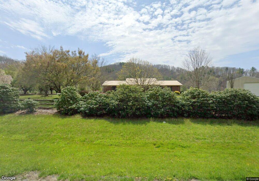
4328 S 226 Hwy Bakersville, NC 28705
Estimated Value: $401,000 - $555,109
3
Beds
3
Baths
2,912
Sq Ft
$165/Sq Ft
Est. Value
About This Home
This home is located at 4328 S 226 Hwy, Bakersville, NC 28705 and is currently estimated at $479,527, approximately $164 per square foot. 4328 S 226 Hwy is a home located in Mitchell County with nearby schools including Gouge Elementary School, Bowman Middle School, and Mitchell High School.
Ownership History
Date
Name
Owned For
Owner Type
Purchase Details
Closed on
Apr 29, 2021
Sold by
Burleson James Morris and Burleson Judy Ann
Bought by
Roudbari Amy and Roudbari Shahram
Current Estimated Value
Home Financials for this Owner
Home Financials are based on the most recent Mortgage that was taken out on this home.
Original Mortgage
$277,000
Outstanding Balance
$250,097
Interest Rate
3%
Mortgage Type
New Conventional
Estimated Equity
$229,430
Create a Home Valuation Report for This Property
The Home Valuation Report is an in-depth analysis detailing your home's value as well as a comparison with similar homes in the area
Home Values in the Area
Average Home Value in this Area
Purchase History
| Date | Buyer | Sale Price | Title Company |
|---|---|---|---|
| Roudbari Amy | $235,000 | None Available | |
| Ingram Denver Stanley | $352,000 | None Available |
Source: Public Records
Mortgage History
| Date | Status | Borrower | Loan Amount |
|---|---|---|---|
| Open | Ingram Denver Stanley | $277,000 |
Source: Public Records
Tax History Compared to Growth
Tax History
| Year | Tax Paid | Tax Assessment Tax Assessment Total Assessment is a certain percentage of the fair market value that is determined by local assessors to be the total taxable value of land and additions on the property. | Land | Improvement |
|---|---|---|---|---|
| 2025 | $2,262 | $353,500 | $52,400 | $301,100 |
| 2024 | $2,227 | $353,500 | $52,400 | $301,100 |
| 2023 | $2,227 | $353,500 | $52,400 | $301,100 |
| 2022 | $2,227 | $353,500 | $52,400 | $301,100 |
| 2021 | $2,291 | $352,000 | $65,200 | $286,800 |
| 2020 | $2,291 | $352,000 | $65,200 | $286,800 |
| 2019 | $2,291 | $352,000 | $65,200 | $286,800 |
| 2018 | $2,291 | $352,000 | $65,200 | $286,800 |
| 2017 | $2,317 | $356,100 | $65,200 | $290,900 |
| 2016 | $2,137 | $356,100 | $65,200 | $290,900 |
| 2015 | $214 | $356,100 | $65,200 | $290,900 |
| 2014 | $2,137 | $356,100 | $65,200 | $290,900 |
Source: Public Records
Map
Nearby Homes
- 00 Ashland Mountain Rd
- 5218 S 226 Hwy
- TBD Elkins Rd
- 202 Snow Hill Rd
- 00 Elkins Rd
- 370 Bear Creek Church Rd
- 1371 Wing Rd
- TBD Robert Phillips Rd
- 208 Murdock Rd
- 71 Travis Ln
- 1424 Bear Creek Rd
- 607 Fred Sparks Rd
- 249 Starlin Mountain Rd
- 75 Appalachian Way
- 496 English Ln
- 3734 Snow Creek Rd
- 987 White Oak Rd
- 407 Terrell Dr
- 49 Loggy Hollow Rd
- 244 Mcmahon Ln
- 4328 S 226 Hwy
- 4328 S 226 Hwy
- 224 Wing Rd
- 4390 S 226 Hwy
- 4390 S 226 Hwy
- 4232 S 226 Hwy
- 73 Ledger Dr
- 67 Maple Leaf Ln
- 301 Wing Rd
- 308 Wing Rd
- 132 Amsoil Dr
- 37 Maple Leaf Ln
- 62 Ledger Dr
- 356 Wing Rd
- 4195 S 226 Hwy
- 106 Ledger Dr
- 85 Phillips Ridge
- 215 Ashland Mountain Rd Unit 13
- 4560 S 226 Hwy
- 237 Ashland Mountain Rd