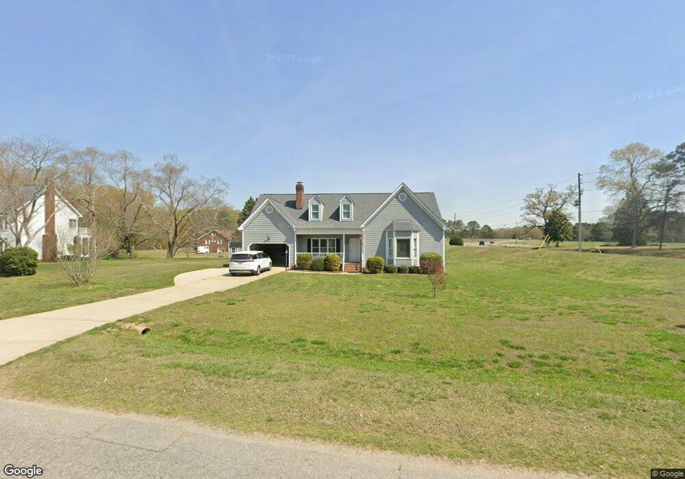
4341 S Mountain Dr Raleigh, NC 27603
Estimated Value: $431,000 - $523,000
3
Beds
2
Baths
1,584
Sq Ft
$306/Sq Ft
Est. Value
About This Home
This home is located at 4341 S Mountain Dr, Raleigh, NC 27603 and is currently estimated at $485,222, approximately $306 per square foot. 4341 S Mountain Dr is a home located in Wake County with nearby schools including Vance Elementary School, North Garner Middle, and Garner High.
Ownership History
Date
Name
Owned For
Owner Type
Purchase Details
Closed on
Jan 24, 2025
Sold by
Reese Clint Manly and Reese Pamela Jean
Bought by
Reese Clint Manly
Current Estimated Value
Purchase Details
Closed on
May 28, 2014
Sold by
Fuquay Bobby O and Hyatt Harry W
Bought by
Reese Clint M and Reese Clint M
Purchase Details
Closed on
Oct 7, 2004
Sold by
Keiter Ethel L
Bought by
Fuquay Ruby T
Purchase Details
Closed on
Dec 23, 1997
Sold by
Akinwole Barbara S
Bought by
Keiter Glenn S and Keiter Ethel L
Create a Home Valuation Report for This Property
The Home Valuation Report is an in-depth analysis detailing your home's value as well as a comparison with similar homes in the area
Home Values in the Area
Average Home Value in this Area
Purchase History
| Date | Buyer | Sale Price | Title Company |
|---|---|---|---|
| Reese Clint Manly | -- | None Listed On Document | |
| Reese Clint Manly | -- | None Listed On Document | |
| Reese Clint M | $175,000 | None Available | |
| Fuquay Ruby T | $156,000 | -- | |
| Keiter Glenn S | $142,500 | -- |
Source: Public Records
Tax History Compared to Growth
Tax History
| Year | Tax Paid | Tax Assessment Tax Assessment Total Assessment is a certain percentage of the fair market value that is determined by local assessors to be the total taxable value of land and additions on the property. | Land | Improvement |
|---|---|---|---|---|
| 2025 | $2,400 | $526,506 | $100,000 | $426,506 |
| 2024 | $3,290 | $526,506 | $100,000 | $426,506 |
| 2023 | $2,538 | $322,976 | $56,000 | $266,976 |
| 2022 | $2,353 | $322,976 | $56,000 | $266,976 |
| 2021 | $1,690 | $322,976 | $56,000 | $266,976 |
| 2020 | $2,252 | $322,976 | $56,000 | $266,976 |
| 2019 | $2,124 | $257,631 | $56,000 | $201,631 |
| 2018 | $1,953 | $257,631 | $56,000 | $201,631 |
| 2017 | $1,852 | $258,631 | $56,000 | $202,631 |
| 2016 | $1,514 | $214,501 | $56,000 | $158,501 |
| 2015 | $1,000 | $216,614 | $44,000 | $172,614 |
| 2014 | $1,445 | $216,614 | $44,000 | $172,614 |
Source: Public Records
Map
Nearby Homes
- 1105 High Summit Dr
- 101 Lyle Rd
- 1124 Armsleigh Ct
- 7805 Crestwood Dr
- 1121 Whitecroft Dr
- 173 Tawny Slope Ct
- 51 Cheshire Downs Ct
- 342 Amber Acorn Ave
- 4705 Trotter Dr
- 8529 Hurst Dr
- 286 Fosterton Cottage Way
- 372 Amber Acorn Ave
- 264 Fosterton Cottage Way
- 262 Fosterton Cottage Way
- 252 Fosterton Cottage Way
- 684 Ben Ledi Ct
- 130 Tawny Slope Ct
- 130 Tawny Slope Ct Unit 19
- 4620 Cresta Dr
- 517 Prestonfield Way
- 4333 S Mountain Dr
- 8828 Ten Ten Rd
- 4336 S Mountain Dr
- 4329 S Mountain Dr
- 8900 Ten Ten Rd
- 8909 Ten Ten Rd
- 1105 Sky Ridge Dr
- 4320 S Mountain Dr
- 4321 S Mountain Dr
- 1104 Sky Ridge Dr
- 1109 Sky Ridge Dr
- 4317 S Mountain Dr
- 4200 Buffaloe Farm Ln
- 1108 Sky Ridge Dr
- 1101 Sky Point Ct
- 1109 Sky Point Ct
- 4309 S Mountain Dr
- 8937 Ten Ten Rd
- 1025 S Knoll Ct
- 1017 S Knoll Ct