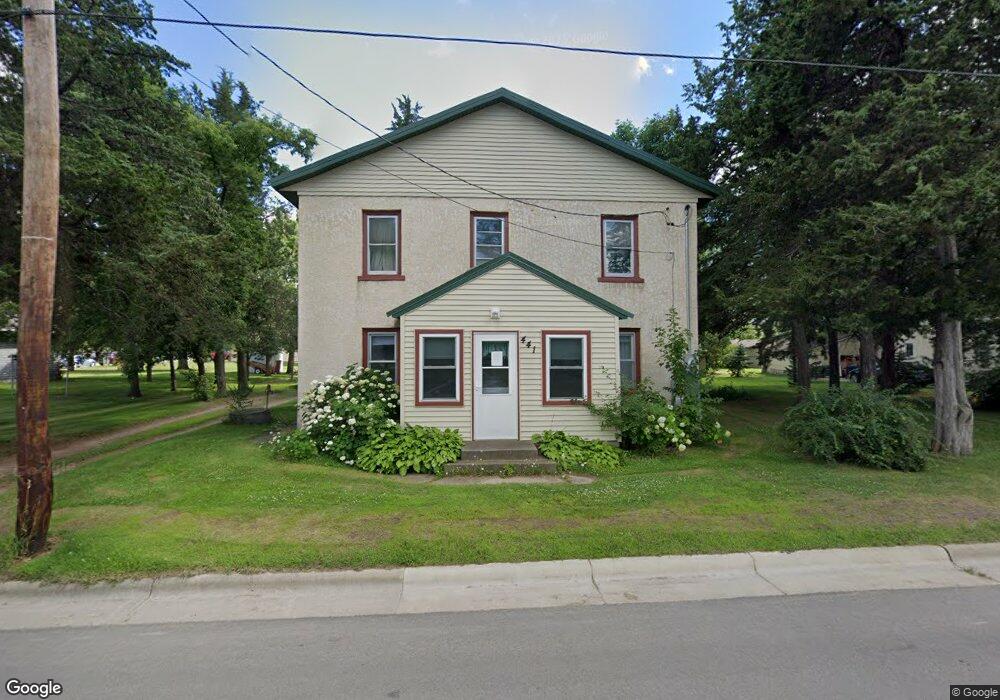
441 Main St W Richmond, MN 56368
Estimated Value: $172,000 - $307,000
4
Beds
1
Bath
1,798
Sq Ft
$135/Sq Ft
Est. Value
About This Home
This home is located at 441 Main St W, Richmond, MN 56368 and is currently estimated at $242,692, approximately $134 per square foot. 441 Main St W is a home located in Stearns County with nearby schools including Rocori Senior High School and Saints Peter & Paul Catholic School.
Ownership History
Date
Name
Owned For
Owner Type
Purchase Details
Closed on
Oct 1, 2024
Sold by
Claussen Shirley Ann
Bought by
Claussen Dale William
Current Estimated Value
Purchase Details
Closed on
Nov 21, 2022
Sold by
The Estate Of Richard C Ethen
Bought by
Claussen Dale and Claussen Shirley
Purchase Details
Closed on
Mar 22, 1993
Sold by
Lemke Magdalena
Bought by
Ethen Richard
Create a Home Valuation Report for This Property
The Home Valuation Report is an in-depth analysis detailing your home's value as well as a comparison with similar homes in the area
Home Values in the Area
Average Home Value in this Area
Purchase History
| Date | Buyer | Sale Price | Title Company |
|---|---|---|---|
| Claussen Dale William | -- | None Listed On Document | |
| Claussen Dale | $90,000 | -- | |
| Ethen Richard | $45,400 | -- |
Source: Public Records
Tax History Compared to Growth
Tax History
| Year | Tax Paid | Tax Assessment Tax Assessment Total Assessment is a certain percentage of the fair market value that is determined by local assessors to be the total taxable value of land and additions on the property. | Land | Improvement |
|---|---|---|---|---|
| 2025 | $1,806 | $176,700 | $47,500 | $129,200 |
| 2024 | $1,670 | $165,700 | $47,500 | $118,200 |
| 2023 | $1,254 | $152,200 | $43,800 | $108,400 |
| 2022 | $1,244 | $107,800 | $40,000 | $67,800 |
| 2021 | $1,282 | $107,800 | $40,000 | $67,800 |
| 2020 | $1,308 | $108,800 | $40,000 | $68,800 |
| 2019 | $1,248 | $106,700 | $36,900 | $69,800 |
| 2018 | $1,218 | $97,700 | $34,400 | $63,300 |
| 2017 | $1,154 | $94,000 | $34,400 | $59,600 |
| 2016 | $1,164 | $0 | $0 | $0 |
| 2015 | $1,154 | $0 | $0 | $0 |
| 2014 | -- | $0 | $0 | $0 |
Source: Public Records
Map
Nearby Homes
- 261 Main St W
- 577 Main St W
- 148 Main St W
- 205 Grant Ave SW
- 153 Central Ave S
- 101 Barry Loop NW
- 232 Main St E
- 22296 Hall Ave SW
- 448 1st St NE
- 464 Main St E
- XXX Eastfield Dr
- 21107 State Highway 23
- 22579 Fordham Rd
- 20734 Black Cherry Dr
- 21312 State Highway 22 #4
- 21312 State Highway 22 Unit 20
- 21312 State Highway 22 Unit 25
- 22314 Mallard Ct
- 20554 Elkview Ct
- 20568 Elkview Ct
- 457 Main St W
- 457 457 Main-Street-w
- 19 Elm Ave SW
- 29 Elm Ave SW
- 460 1st St SW
- 444 Main St W
- 11 Elm Ave NW
- 400 400 1st-Avenue-sw
- 365 Main St W
- 454 Main St W
- 13 Dutch Ave SW
- 360 1st St SW Unit 584
- 345 Main St W
- 355 Main St W
- 364 Main St W
- 416 1st St SW
- 545 Main St W
- 55 Dutch Ave SW
- 17 Dutch Ave NW
- 437 1st St NW