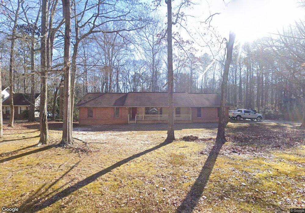
45 Shea Ln Stockbridge, GA 30281
Estimated Value: $244,000 - $265,000
3
Beds
2
Baths
1,888
Sq Ft
$135/Sq Ft
Est. Value
About This Home
This home is located at 45 Shea Ln, Stockbridge, GA 30281 and is currently estimated at $255,508, approximately $135 per square foot. 45 Shea Ln is a home located in Henry County with nearby schools including Austin Road Elementary School, Austin Road Middle School, and Woodland High School.
Ownership History
Date
Name
Owned For
Owner Type
Purchase Details
Closed on
May 15, 2009
Sold by
Manders Helen N
Bought by
Hill Perry L
Current Estimated Value
Home Financials for this Owner
Home Financials are based on the most recent Mortgage that was taken out on this home.
Original Mortgage
$152,200
Outstanding Balance
$95,956
Interest Rate
4.81%
Mortgage Type
VA
Estimated Equity
$159,552
Purchase Details
Closed on
Jan 24, 2005
Sold by
Manders Virgil J
Bought by
Manders Helen N
Create a Home Valuation Report for This Property
The Home Valuation Report is an in-depth analysis detailing your home's value as well as a comparison with similar homes in the area
Home Values in the Area
Average Home Value in this Area
Purchase History
| Date | Buyer | Sale Price | Title Company |
|---|---|---|---|
| Hill Perry L | $149,000 | -- | |
| Manders Helen N | -- | -- |
Source: Public Records
Mortgage History
| Date | Status | Borrower | Loan Amount |
|---|---|---|---|
| Open | Hill Perry L | $152,200 |
Source: Public Records
Tax History Compared to Growth
Tax History
| Year | Tax Paid | Tax Assessment Tax Assessment Total Assessment is a certain percentage of the fair market value that is determined by local assessors to be the total taxable value of land and additions on the property. | Land | Improvement |
|---|---|---|---|---|
| 2025 | $725 | $122,732 | $16,000 | $106,732 |
| 2024 | $725 | $107,520 | $16,000 | $91,520 |
| 2023 | $464 | $103,640 | $12,000 | $91,640 |
| 2022 | $609 | $84,880 | $12,000 | $72,880 |
| 2021 | $609 | $69,440 | $12,000 | $57,440 |
| 2020 | $609 | $60,360 | $10,000 | $50,360 |
| 2019 | $609 | $62,200 | $10,000 | $52,200 |
| 2018 | $609 | $56,800 | $10,000 | $46,800 |
| 2016 | $1,394 | $52,600 | $8,000 | $44,600 |
| 2015 | $1,218 | $47,000 | $7,200 | $39,800 |
| 2014 | $891 | $38,440 | $7,200 | $31,240 |
Source: Public Records
Map
Nearby Homes
- 80 Sandy Dr
- 106 Garden Trail
- 25 Mendy Ln
- 130 Fairview Dr
- 176 Fairoaks Cir
- 203 Farmbrook Pkwy
- 204 Benefield Ct
- 313 Ashborough Place
- 116 Kalsum Trail
- 429 Saint Surrey Way
- 216 Johns Creek Ln
- 222 Farmbrook Pkwy
- 4241 Hearn Rd
- 6733 Highway 155 N
- 200 Johns Creek Ln
- 226 Farmbrook Pkwy
- 0 Kingsbrook Dr Unit 19 LOTS 10399843
- 500 Saint Sambar Dr