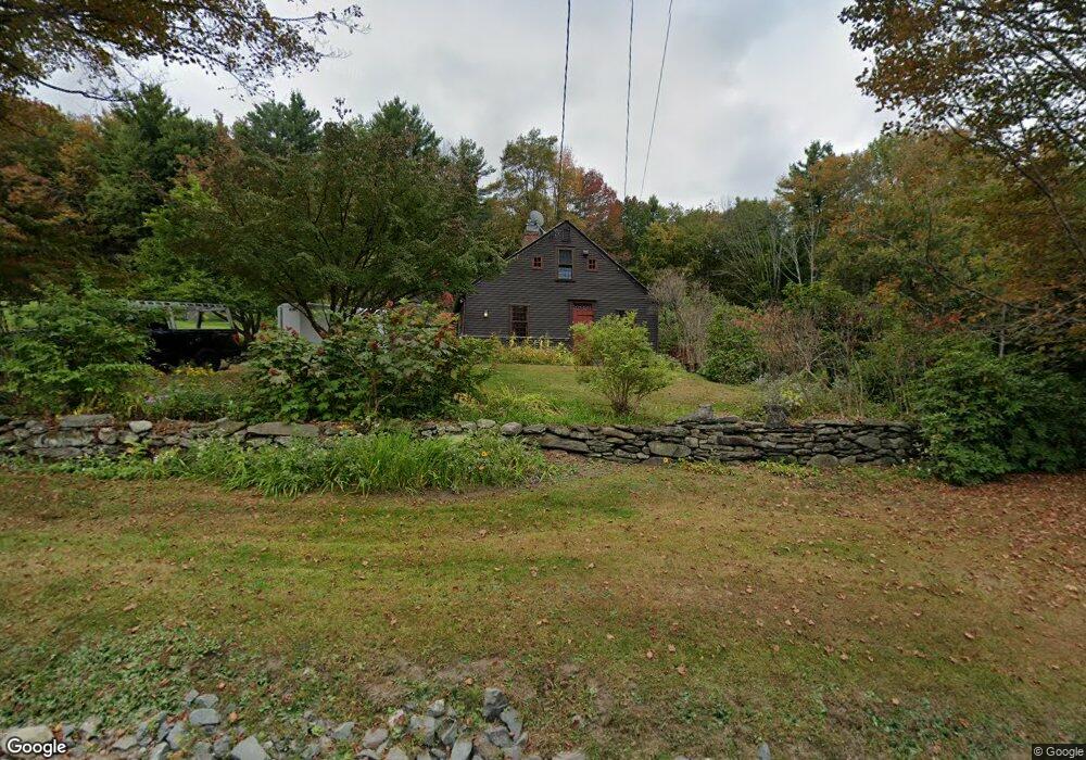
453 Hart Rd Conway, MA 01341
Estimated Value: $573,000 - $742,000
2
Beds
3
Baths
2,239
Sq Ft
$297/Sq Ft
Est. Value
About This Home
This home is located at 453 Hart Rd, Conway, MA 01341 and is currently estimated at $665,643, approximately $297 per square foot. 453 Hart Rd is a home located in Franklin County with nearby schools including Frontier Regional School.
Ownership History
Date
Name
Owned For
Owner Type
Purchase Details
Closed on
Feb 13, 2025
Sold by
Darrow Carl E
Bought by
Davis John and Heffner Jason
Current Estimated Value
Purchase Details
Closed on
Jun 9, 1999
Sold by
Mattson Mark D and Lane Judith L
Bought by
Darrow Carl E and Darrow Mildred C
Purchase Details
Closed on
Dec 22, 1995
Sold by
Dolan Barbara W and Weaver Mary B
Bought by
Mattson Mark D and Lane Judith L
Purchase Details
Closed on
Feb 3, 1992
Sold by
Dolan Barbara W and Weaver Marya B
Bought by
Mattson Mark D and Lane Judith L
Home Financials for this Owner
Home Financials are based on the most recent Mortgage that was taken out on this home.
Original Mortgage
$150,000
Interest Rate
8.44%
Mortgage Type
Purchase Money Mortgage
Create a Home Valuation Report for This Property
The Home Valuation Report is an in-depth analysis detailing your home's value as well as a comparison with similar homes in the area
Home Values in the Area
Average Home Value in this Area
Purchase History
| Date | Buyer | Sale Price | Title Company |
|---|---|---|---|
| Davis John | $620,000 | None Available | |
| Davis John | $620,000 | None Available | |
| Darrow Carl E | $290,000 | -- | |
| Darrow Carl E | $290,000 | -- | |
| Mattson Mark D | $50,000 | -- | |
| Mattson Mark D | $50,000 | -- | |
| Mattson Mark D | $240,000 | -- |
Source: Public Records
Mortgage History
| Date | Status | Borrower | Loan Amount |
|---|---|---|---|
| Previous Owner | Mattson Mark D | $150,000 |
Source: Public Records
Tax History Compared to Growth
Tax History
| Year | Tax Paid | Tax Assessment Tax Assessment Total Assessment is a certain percentage of the fair market value that is determined by local assessors to be the total taxable value of land and additions on the property. | Land | Improvement |
|---|---|---|---|---|
| 2025 | $9,026 | $625,100 | $177,900 | $447,200 |
| 2024 | $8,354 | $509,400 | $161,900 | $347,500 |
| 2023 | $8,736 | $509,400 | $161,900 | $347,500 |
| 2022 | $8,505 | $473,800 | $152,000 | $321,800 |
| 2021 | $8,414 | $449,200 | $146,700 | $302,500 |
| 2020 | $1,620 | $435,000 | $145,700 | $289,300 |
| 2019 | $8,113 | $435,000 | $145,700 | $289,300 |
| 2018 | $8,048 | $435,000 | $145,700 | $289,300 |
| 2017 | $10,199 | $574,600 | $261,500 | $313,100 |
| 2016 | $7,519 | $450,800 | $134,600 | $316,200 |
| 2015 | $7,289 | $450,800 | $134,600 | $316,200 |
Source: Public Records
Map
Nearby Homes
- 85 Dacey Rd
- lot 1 Shelburne Falls Rd
- 102 Elm St
- 105 - 107 Bridge St
- 10 Deerfield Ave Unit 5
- 10 Deerfield Ave Unit 2
- 33 Williams St
- 240 Beldingville Rd
- 14 River St
- 0 Pleasant St
- 7 Hog Hollow Rd
- 156 Ashfield Rd
- 0 Upper St
- 163 S Shelburne Rd
- 0 Ashfield Rd
- 414 Mohawk Trail
- 473 N Poland Rd
- 2151 Route 2
- 2155 Massachusetts 2
- 23 Robbins Rd
- 2811 Shelburne Falls Rd
- 373 Hart Rd
- 388 Hart Rd
- 388 Hart Rd Unit 1
- 2848 Shelburne Falls Rd
- 2739 Shelburne Falls Rd
- 2790 Shelburne Falls Rd
- 329 Hart Rd
- 315 Hart Rd
- 354 Hart Rd
- 305 Hart Rd
- 317 Hart Rd
- 2701 Shelburne Falls Rd
- 326 Hart Rd
- 2966 Shelburne Falls Rd
- 363 Hart Rd
- 235 Hart Rd
- 180 Hart Rd
- 3014 Shelburne Falls Rd
- 3033 Shelburne Falls Rd