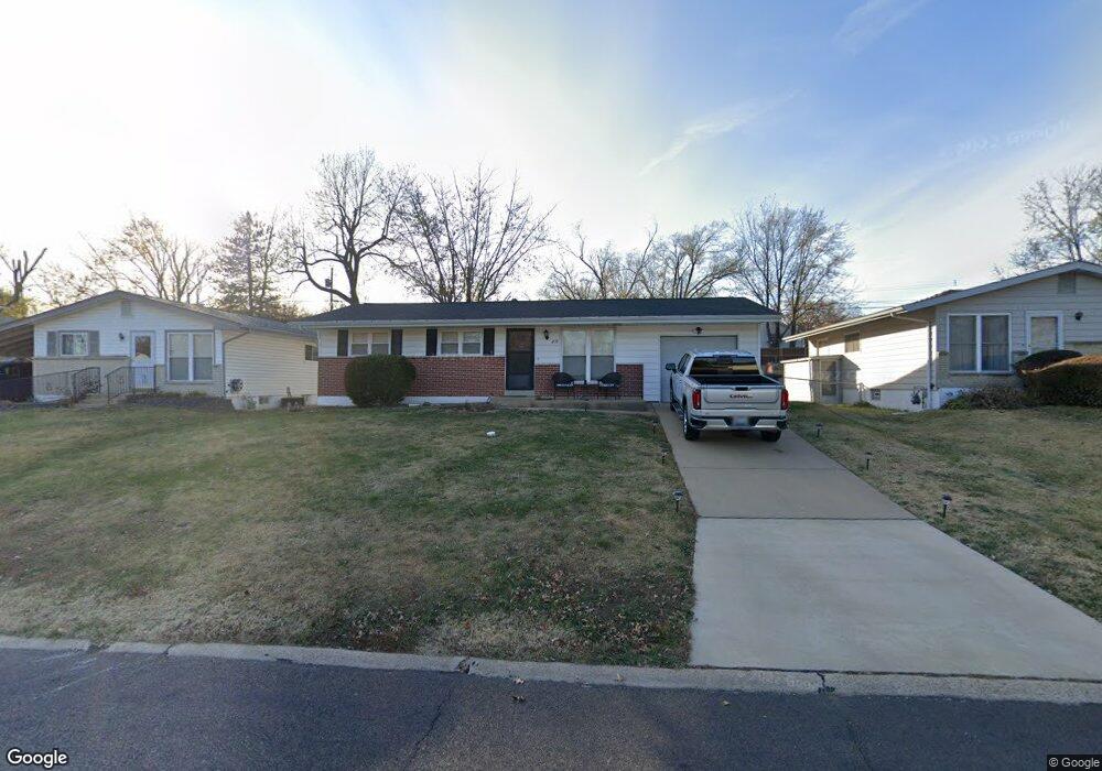
4535 Burncoate Dr Saint Louis, MO 63129
Estimated Value: $221,645 - $242,000
3
Beds
1
Bath
864
Sq Ft
$264/Sq Ft
Est. Value
About This Home
This home is located at 4535 Burncoate Dr, Saint Louis, MO 63129 and is currently estimated at $228,411, approximately $264 per square foot. 4535 Burncoate Dr is a home located in St. Louis County with nearby schools including Wohlwend Elementary School, Bernard Middle School, and Oakville Senior High School.
Ownership History
Date
Name
Owned For
Owner Type
Purchase Details
Closed on
Nov 30, 2020
Sold by
Hubbard Ricky J and Hubbard Marilyn L
Bought by
Hubbard Ricky J and Hubbard Marilyn L
Current Estimated Value
Home Financials for this Owner
Home Financials are based on the most recent Mortgage that was taken out on this home.
Original Mortgage
$97,000
Outstanding Balance
$86,359
Interest Rate
2.7%
Mortgage Type
New Conventional
Estimated Equity
$142,052
Purchase Details
Closed on
Jul 20, 2012
Sold by
Stewart Donna J and Winiger Tracy J
Bought by
Hubbard Rick J
Home Financials for this Owner
Home Financials are based on the most recent Mortgage that was taken out on this home.
Original Mortgage
$109,971
Interest Rate
4.4%
Mortgage Type
FHA
Create a Home Valuation Report for This Property
The Home Valuation Report is an in-depth analysis detailing your home's value as well as a comparison with similar homes in the area
Home Values in the Area
Average Home Value in this Area
Purchase History
| Date | Buyer | Sale Price | Title Company |
|---|---|---|---|
| Hubbard Ricky J | -- | Title Partners Agency Llc | |
| Hubbard Rick J | $112,000 | It |
Source: Public Records
Mortgage History
| Date | Status | Borrower | Loan Amount |
|---|---|---|---|
| Open | Hubbard Ricky J | $97,000 | |
| Closed | Hubbard Rick J | $109,971 |
Source: Public Records
Tax History Compared to Growth
Tax History
| Year | Tax Paid | Tax Assessment Tax Assessment Total Assessment is a certain percentage of the fair market value that is determined by local assessors to be the total taxable value of land and additions on the property. | Land | Improvement |
|---|---|---|---|---|
| 2025 | $2,131 | $40,490 | $20,240 | $20,250 |
| 2024 | $2,131 | $31,540 | $9,270 | $22,270 |
| 2023 | $2,104 | $31,540 | $9,270 | $22,270 |
| 2022 | $1,840 | $27,680 | $10,960 | $16,720 |
| 2021 | $1,781 | $27,680 | $10,960 | $16,720 |
| 2020 | $1,788 | $26,430 | $10,960 | $15,470 |
| 2019 | $1,783 | $26,430 | $10,960 | $15,470 |
| 2018 | $1,626 | $21,740 | $6,900 | $14,840 |
| 2017 | $1,624 | $21,740 | $6,900 | $14,840 |
| 2016 | $1,594 | $20,470 | $5,190 | $15,280 |
| 2015 | $1,465 | $20,470 | $5,190 | $15,280 |
| 2014 | $1,535 | $21,260 | $5,680 | $15,580 |
Source: Public Records
Map
Nearby Homes
- 141 Stallard Ln
- 4555 Burncoate Dr
- 4460 Telegraph Rd
- 2 Freeman Dr
- 236 Tapestry Dr
- 5228 Kings Park Dr
- 4322 Martyridge Dr
- 223 Freeman Dr
- 200 Rouen Dr
- 5405 Edelweis Ln
- 2408 Whitshire Dr
- 2675 Victron Dr
- 2552 Coppergate Square Dr
- 5126 Firelight Ct
- 337 Saddle Back Dr
- 4130 Saddle Back Ct
- 5501 Dober Ln
- 517 Aqua Ridge Dr
- 144 Martigney Dr
- 4301 Heinle Dr
- 4539 Burncoate Dr
- 4531 Burncoate Dr
- 4543 Burncoate Dr
- 4527 Burncoate Dr
- 4514 Telegraph Rd
- 4547 Burncoate Dr
- 131 Stallard Ln
- 4540 Burncoate Dr
- 4551 Burncoate Dr
- 4523 Burncoate Dr
- 4500 Telegraph Rd Unit 101,102
- 4500 Telegraph Rd Unit 206
- 4524 Burncoate Dr
- 137 Stallard Ln
- 136 Stallard Ln
- 4550 Burncoate Dr
- 4519 Burncoate Dr
- 4520 Burncoate Dr
- 140 Stallard Ln
- 4515 Burncoate Dr