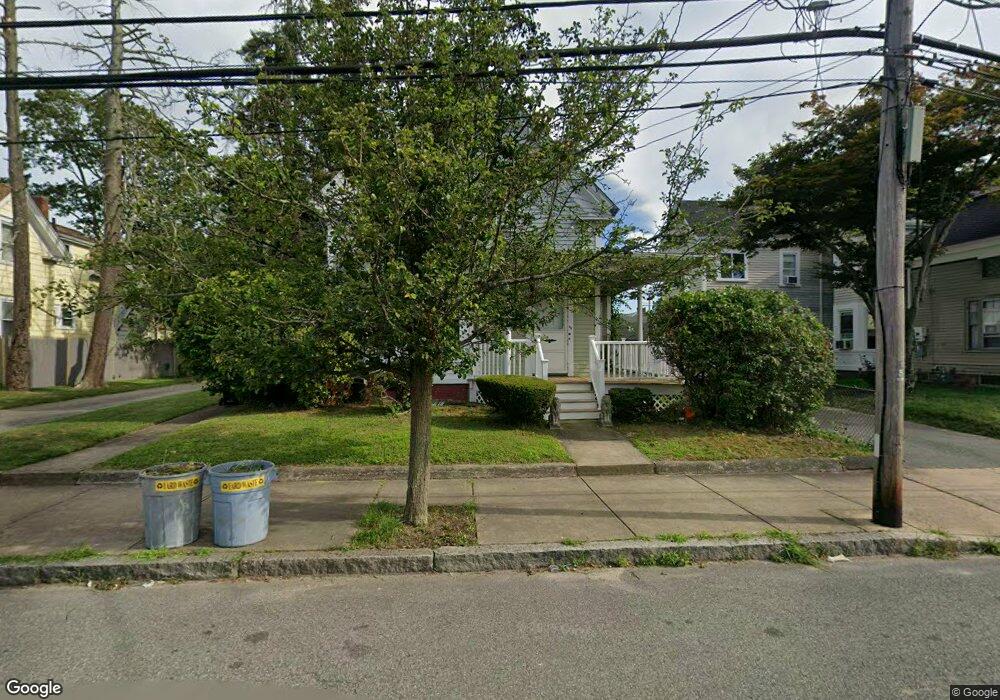
46 Keith Ave Brockton, MA 02301
Campello NeighborhoodEstimated Value: $513,120 - $727,000
3
Beds
2
Baths
1,491
Sq Ft
$426/Sq Ft
Est. Value
About This Home
This home is located at 46 Keith Ave, Brockton, MA 02301 and is currently estimated at $634,780, approximately $425 per square foot. 46 Keith Ave is a home located in Plymouth County with nearby schools including Davis K-8 School, John F. Kennedy Elementary School, and South Middle School.
Ownership History
Date
Name
Owned For
Owner Type
Purchase Details
Closed on
Jan 6, 2004
Sold by
Crosby Robert D and Starnes Linda A
Bought by
Blake Maurice
Current Estimated Value
Create a Home Valuation Report for This Property
The Home Valuation Report is an in-depth analysis detailing your home's value as well as a comparison with similar homes in the area
Home Values in the Area
Average Home Value in this Area
Purchase History
| Date | Buyer | Sale Price | Title Company |
|---|---|---|---|
| Blake Maurice | $252,900 | -- |
Source: Public Records
Mortgage History
| Date | Status | Borrower | Loan Amount |
|---|---|---|---|
| Open | Blake Maurice | $105,000 | |
| Open | Blake Maurice | $384,750 | |
| Closed | Blake Maurice | $342,000 | |
| Closed | Blake Maurice | $281,700 |
Source: Public Records
Tax History Compared to Growth
Tax History
| Year | Tax Paid | Tax Assessment Tax Assessment Total Assessment is a certain percentage of the fair market value that is determined by local assessors to be the total taxable value of land and additions on the property. | Land | Improvement |
|---|---|---|---|---|
| 2025 | $6,964 | $575,100 | $140,200 | $434,900 |
| 2024 | $6,786 | $564,600 | $140,200 | $424,400 |
| 2023 | $5,768 | $444,400 | $105,000 | $339,400 |
| 2022 | $5,789 | $414,400 | $95,400 | $319,000 |
| 2021 | $5,461 | $376,600 | $79,400 | $297,200 |
| 2020 | $4,884 | $322,400 | $74,200 | $248,200 |
| 2019 | $5,113 | $329,000 | $72,400 | $256,600 |
| 2018 | $4,233 | $263,600 | $72,400 | $191,200 |
| 2017 | $3,967 | $246,400 | $72,400 | $174,000 |
| 2016 | $3,909 | $225,200 | $70,200 | $155,000 |
| 2015 | $2,848 | $156,900 | $70,200 | $86,700 |
| 2014 | $2,990 | $164,900 | $70,200 | $94,700 |
Source: Public Records
Map
Nearby Homes
- 115 Market St
- 65 Tremont St
- 223 Clinton St Unit 10
- 223 Clinton St Unit 3
- 977 Warren Ave
- 35 Longworth Ave Unit 17
- 47 Southworth St
- 163 S Leyden St
- 936 Warren Ave
- 103 Clinton St
- 137 Channing Ave
- 358 Copeland St
- 15 1st St
- 153 Bouve Ave
- 176 Ettrick St
- 37 Menlo Ave
- 20 Custer St
- 61 Myrtle St
- 29 Hancock St
- 16 Hancock St