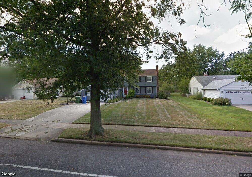
468 Covered Bridge Rd Cherry Hill, NJ 08034
Estimated Value: $557,000 - $593,000
--
Bed
--
Bath
2,089
Sq Ft
$272/Sq Ft
Est. Value
About This Home
This home is located at 468 Covered Bridge Rd, Cherry Hill, NJ 08034 and is currently estimated at $568,426, approximately $272 per square foot. 468 Covered Bridge Rd is a home located in Camden County with nearby schools including A. Russell Knight Elementary School, John A Carusi Middle School, and Cherry Hill High-West High School.
Ownership History
Date
Name
Owned For
Owner Type
Purchase Details
Closed on
Jan 26, 2009
Sold by
Rosen Seth and Kelly Dawn
Bought by
Kelly Dawn
Current Estimated Value
Home Financials for this Owner
Home Financials are based on the most recent Mortgage that was taken out on this home.
Original Mortgage
$361,212
Outstanding Balance
$229,548
Interest Rate
5.2%
Mortgage Type
FHA
Estimated Equity
$338,878
Purchase Details
Closed on
Jul 18, 2007
Sold by
Azarnia Nozar and Azarnia Fatemeh
Bought by
Kelly Dawn
Home Financials for this Owner
Home Financials are based on the most recent Mortgage that was taken out on this home.
Original Mortgage
$294,750
Interest Rate
6.78%
Mortgage Type
New Conventional
Create a Home Valuation Report for This Property
The Home Valuation Report is an in-depth analysis detailing your home's value as well as a comparison with similar homes in the area
Home Values in the Area
Average Home Value in this Area
Purchase History
| Date | Buyer | Sale Price | Title Company |
|---|---|---|---|
| Kelly Dawn | -- | -- | |
| Kelly Dawn | $327,500 | -- |
Source: Public Records
Mortgage History
| Date | Status | Borrower | Loan Amount |
|---|---|---|---|
| Open | Kelly Dawn | $361,212 | |
| Previous Owner | Kelly Dawn | $294,750 |
Source: Public Records
Tax History Compared to Growth
Tax History
| Year | Tax Paid | Tax Assessment Tax Assessment Total Assessment is a certain percentage of the fair market value that is determined by local assessors to be the total taxable value of land and additions on the property. | Land | Improvement |
|---|---|---|---|---|
| 2025 | $10,269 | $230,300 | $71,100 | $159,200 |
| 2024 | $9,677 | $230,300 | $71,100 | $159,200 |
| 2023 | $9,677 | $230,300 | $71,100 | $159,200 |
| 2022 | $9,410 | $230,300 | $71,100 | $159,200 |
| 2021 | $9,440 | $230,300 | $71,100 | $159,200 |
| 2020 | $9,325 | $230,300 | $71,100 | $159,200 |
| 2019 | $9,320 | $230,300 | $71,100 | $159,200 |
| 2018 | $9,295 | $230,300 | $71,100 | $159,200 |
| 2017 | $9,168 | $230,300 | $71,100 | $159,200 |
| 2016 | $9,046 | $230,300 | $71,100 | $159,200 |
| 2015 | $8,903 | $230,300 | $71,100 | $159,200 |
| 2014 | $8,804 | $230,300 | $71,100 | $159,200 |
Source: Public Records
Map
Nearby Homes
- 1222 Sequoia Rd
- 314 Covered Bridge Rd
- 119 W Riding Rd
- 1217 Forge Rd
- 1227 Cotswold Ln
- 1324 Charleston Rd
- 505 Fern Ave
- 515 Kresson Rd
- 102 Lane of Trees
- 117 Lucerne Blvd
- 1109 Winding Dr
- 217 Redstone Ridge
- 110 Barclay Ln
- 1010 Salem Rd
- 7 Cameo Ct
- 2 Collage Ct
- 405 Barclay Towers
- 307 Provincetown Cir
- 1111 Barclay Towers
- 109 Old Carriage Rd
- 472 Covered Bridge Rd
- 464 Covered Bridge Rd
- 476 Covered Bridge Rd
- 1215 Black Baron Dr
- 1225 Black Baron Dr
- 460 Covered Bridge Rd
- 465 Covered Bridge Rd
- 1205 Black Baron Dr
- 469 Covered Bridge Rd
- 1235 Black Baron Dr
- 505 Tarrington Rd
- 480 Covered Bridge Rd
- 501 Tarrington Rd
- 461 Covered Bridge Rd
- 473 Covered Bridge Rd
- 457 Covered Bridge Rd
- 484 Covered Bridge Rd
- 440 Burning Tree Rd
- 436 Burning Tree Rd
- 451 Covered Bridge Rd