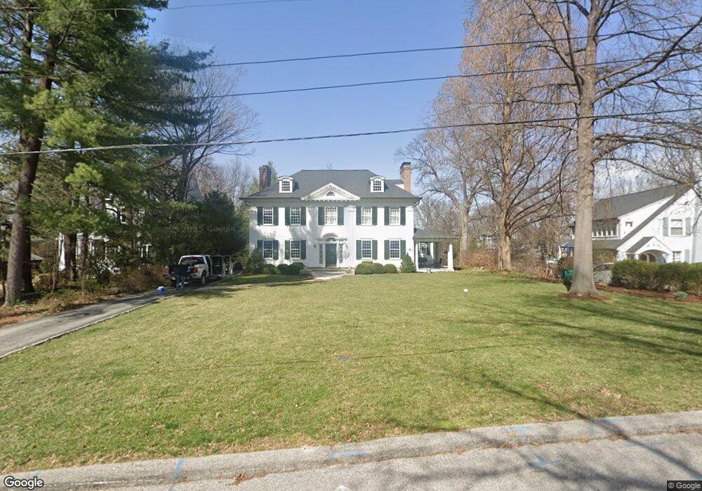
471 Hawthorne Ave Saint Louis, MO 63119
Estimated Value: $1,344,000 - $1,596,255
4
Beds
4
Baths
4,810
Sq Ft
$316/Sq Ft
Est. Value
About This Home
This home is located at 471 Hawthorne Ave, Saint Louis, MO 63119 and is currently estimated at $1,518,314, approximately $315 per square foot. 471 Hawthorne Ave is a home located in St. Louis County with nearby schools including Avery Elementary School, Hixson Middle School, and Webster Groves High School.
Ownership History
Date
Name
Owned For
Owner Type
Purchase Details
Closed on
Jul 3, 2012
Sold by
Eckhardt Millicent C and Eckhardt Bruce N
Bought by
Eckhardt Millicent C and Eckhardt Bruce N
Current Estimated Value
Purchase Details
Closed on
Oct 1, 2009
Sold by
Eckhardt Bruce N and Eckhardt Millicent C
Bought by
Eckhardt Millicent C and Eckhardt Bruce N
Create a Home Valuation Report for This Property
The Home Valuation Report is an in-depth analysis detailing your home's value as well as a comparison with similar homes in the area
Home Values in the Area
Average Home Value in this Area
Purchase History
| Date | Buyer | Sale Price | Title Company |
|---|---|---|---|
| Eckhardt Millicent C | -- | None Available | |
| Eckhardt Millicent C | -- | None Available |
Source: Public Records
Tax History Compared to Growth
Tax History
| Year | Tax Paid | Tax Assessment Tax Assessment Total Assessment is a certain percentage of the fair market value that is determined by local assessors to be the total taxable value of land and additions on the property. | Land | Improvement |
|---|---|---|---|---|
| 2025 | $15,651 | $260,190 | $113,220 | $146,970 |
| 2024 | $15,651 | $226,320 | $88,270 | $138,050 |
| 2023 | $12,061 | $175,100 | $88,270 | $86,830 |
| 2022 | $12,981 | $175,100 | $88,270 | $86,830 |
| 2021 | $12,936 | $182,890 | $88,270 | $94,620 |
| 2020 | $13,329 | $168,100 | $76,820 | $91,280 |
| 2019 | $13,234 | $168,100 | $76,820 | $91,280 |
| 2018 | $11,805 | $133,130 | $50,120 | $83,010 |
| 2017 | $11,725 | $133,130 | $50,120 | $83,010 |
| 2016 | $11,289 | $122,570 | $43,360 | $79,210 |
| 2015 | $11,359 | $122,570 | $43,360 | $79,210 |
| 2014 | $11,673 | $122,570 | $47,180 | $75,390 |
Source: Public Records
Map
Nearby Homes
- 400 Marion Ave
- 619 N Bompart Ave
- 610 Cornelia Ave
- 441 Park Rd
- 544 Summit Ave
- 808 Greeley Ave
- 716 Clark Ave
- 450 E Lockwood Ave Unit 303
- 946 Newport Ave
- 840 Marshall Ave
- 112 Oakwood Ave
- 940 Brookside Ave
- 546 Holland Ave
- 946 Marshall Ave Unit D
- 554 N Laclede Station Rd
- 570 N Laclede Station Rd
- 7723 Suffolk Ave
- 835 N Forest Ave
- 7826 Grove Ave
- 814 Holland Ave
- 477 Hawthorne Ave
- 461 Hawthorne Ave
- 485 Hawthorne Ave
- 457 Hawthorne Ave
- 639 Newport Ave
- 491 Hawthorne Ave
- 635 Newport Ave
- 643 Newport Ave
- 631 Newport Ave
- 468 Hawthorne Ave
- 649 Newport Ave
- 451 Hawthorne Ave
- 476 Hawthorne Ave
- 625 Newport Ave
- 503 N Bompart Ave
- 490 Hawthorne Ave
- 619 Newport Ave
- 300 Park Rd
- 448 Hawthorne Ave
- 418 N Bompart Ave